 Add to Chrome
 Add to Firefox
 Add to Edge
Score-based diffusion nowcasting of GOES imagery
May 15, 2025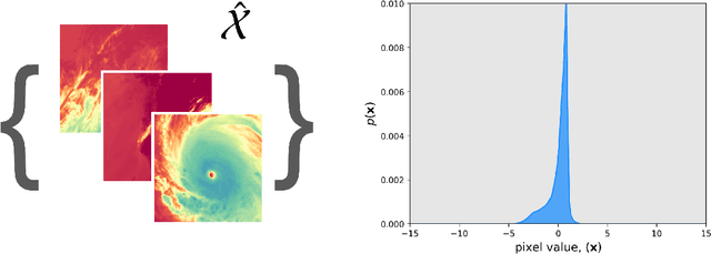


Clouds and precipitation are important for understanding weather and climate. Simulating clouds and precipitation with traditional numerical weather prediction is challenging because of the sub-grid parameterizations required. Machine learning has been explored for forecasting clouds and precipitation, but early machine learning methods often created blurry forecasts. In this paper we explore a newer method, named score-based diffusion, to nowcast (zero to three hour forecast) clouds and precipitation. We discuss the background and intuition of score-based diffusion models - thus providing a starting point for the community - while exploring the methodology's use for nowcasting geostationary infrared imagery. We experiment with three main types of diffusion models: a standard score-based diffusion model (Diff); a residual correction diffusion model (CorrDiff); and a latent diffusion model (LDM). Our results show that the diffusion models are able to not only advect existing clouds, but also generate and decay clouds, including convective initiation. These results are surprising because the forecasts are initiated with only the past 20 mins of infrared satellite imagery. A case study qualitatively shows the preservation of high resolution features longer into the forecast than a conventional mean-squared error trained U-Net. The best of the three diffusion models tested was the CorrDiff approach, outperforming all other diffusion models, the traditional U-Net, and a persistence forecast by one to two kelvin on root mean squared error. The diffusion models also enable out-of-the-box ensemble generation, which shows skillful calibration, with the spread of the ensemble correlating well to the error.
CIRA Guide to Custom Loss Functions for Neural Networks in Environmental Sciences -- Version 1
Jun 17, 2021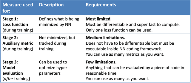
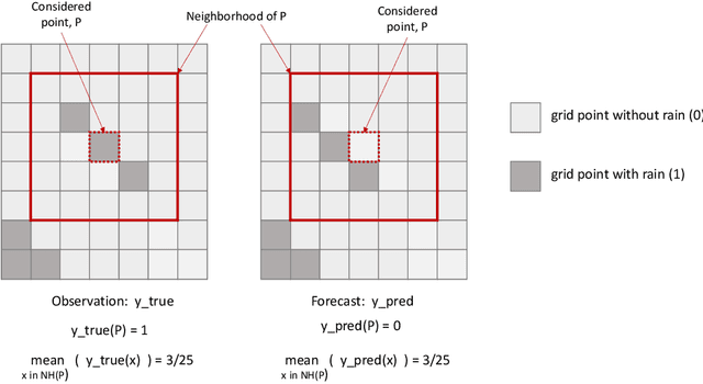
Neural networks are increasingly used in environmental science applications. Furthermore, neural network models are trained by minimizing a loss function, and it is crucial to choose the loss function very carefully for environmental science applications, as it determines what exactly is being optimized. Standard loss functions do not cover all the needs of the environmental sciences, which makes it important for scientists to be able to develop their own custom loss functions so that they can implement many of the classic performance measures already developed in environmental science, including measures developed for spatial model verification. However, there are very few resources available that cover the basics of custom loss function development comprehensively, and to the best of our knowledge none that focus on the needs of environmental scientists. This document seeks to fill this gap by providing a guide on how to write custom loss functions targeted toward environmental science applications. Topics include the basics of writing custom loss functions, common pitfalls, functions to use in loss functions, examples such as fractions skill score as loss function, how to incorporate physical constraints, discrete and soft discretization, and concepts such as focal, robust, and adaptive loss. While examples are currently provided in this guide for Python with Keras and the TensorFlow backend, the basic concepts also apply to other environments, such as Python with PyTorch. Similarly, while the sample loss functions provided here are from meteorology, these are just examples of how to create custom loss functions. Other fields in the environmental sciences have very similar needs for custom loss functions, e.g., for evaluating spatial forecasts effectively, and the concepts discussed here can be applied there as well. All code samples are provided in a GitHub repository.