 Add to Chrome
 Add to Firefox
 Add to Edge
OAM-TCD: A globally diverse dataset of high-resolution tree cover maps
Jul 16, 2024Accurately quantifying tree cover is an important metric for ecosystem monitoring and for assessing progress in restored sites. Recent works have shown that deep learning-based segmentation algorithms are capable of accurately mapping trees at country and continental scales using high-resolution aerial and satellite imagery. Mapping at high (ideally sub-meter) resolution is necessary to identify individual trees, however there are few open-access datasets containing instance level annotations and those that exist are small or not geographically diverse. We present a novel open-access dataset for individual tree crown delineation (TCD) in high-resolution aerial imagery sourced from OpenAerialMap (OAM). Our dataset, OAM-TCD, comprises 5072 2048x2048 px images at 10 cm/px resolution with associated human-labeled instance masks for over 280k individual and 56k groups of trees. By sampling imagery from around the world, we are able to better capture the diversity and morphology of trees in different terrestrial biomes and in both urban and natural environments. Using our dataset, we train reference instance and semantic segmentation models that compare favorably to existing state-of-the-art models. We assess performance through k-fold cross-validation and comparison with existing datasets; additionally we demonstrate compelling results on independent aerial imagery captured over Switzerland and compare to municipal tree inventories and LIDAR-derived canopy maps in the city of Zurich. Our dataset, models and training/benchmark code are publicly released under permissive open-source licenses: Creative Commons (majority CC BY 4.0), and Apache 2.0 respectively.
Learnings from Frontier Development Lab and SpaceML -- AI Accelerators for NASA and ESA
Nov 09, 2020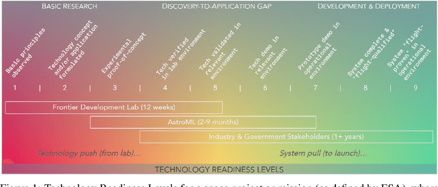
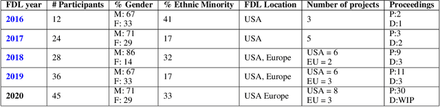
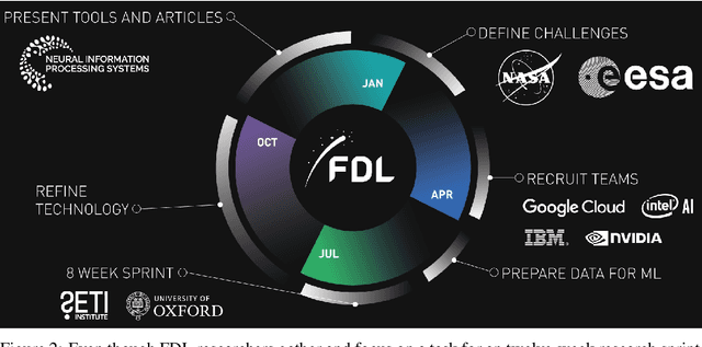
Research with AI and ML technologies lives in a variety of settings with often asynchronous goals and timelines: academic labs and government organizations pursue open-ended research focusing on discoveries with long-term value, while research in industry is driven by commercial pursuits and hence focuses on short-term timelines and return on investment. The journey from research to product is often tacit or ad hoc, resulting in technology transition failures, further exacerbated when research and development is interorganizational and interdisciplinary. Even more, much of the ability to produce results remains locked in the private repositories and know-how of the individual researcher, slowing the impact on future research by others and contributing to the ML community's challenges in reproducibility. With research organizations focused on an exploding array of fields, opportunities for the handover and maturation of interdisciplinary research reduce. With these tensions, we see an emerging need to measure the correctness, impact, and relevance of research during its development to enable better collaboration, improved reproducibility, faster progress, and more trusted outcomes. We perform a case study of the Frontier Development Lab (FDL), an AI accelerator under a public-private partnership from NASA and ESA. FDL research follows principled practices that are grounded in responsible development, conduct, and dissemination of AI research, enabling FDL to churn successful interdisciplinary and interorganizational research projects, measured through NASA's Technology Readiness Levels. We also take a look at the SpaceML Open Source Research Program, which helps accelerate and transition FDL's research to deployable projects with wide spread adoption amongst citizen scientists.
Flood Detection On Low Cost Orbital Hardware
Oct 14, 2019
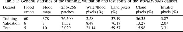
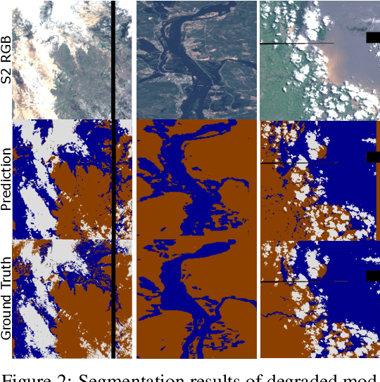
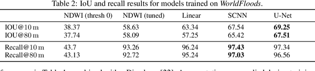
Satellite imaging is a critical technology for monitoring and responding to natural disasters such as flooding. Despite the capabilities of modern satellites, there is still much to be desired from the perspective of first response organisations like UNICEF. Two main challenges are rapid access to data, and the ability to automatically identify flooded regions in images. We describe a prototypical flood segmentation system, identifying cloud, water and land, that could be deployed on a constellation of small satellites, performing processing on board to reduce downlink bandwidth by 2 orders of magnitude. We target PhiSat-1, part of the FSSCAT mission, which is planned to be launched by the European Space Agency (ESA) near the start of 2020 as a proof of concept for this new technology.