 Add to Chrome
 Add to Firefox
 Add to Edge
Hardware-triggered Time Synchronization of Roadside Multi-lidar, Multi-camera Measurement System for Accurate Data Alignment
Jul 17, 2026
Accurate temporal alignment of heterogeneous sensors is necessary for reliable environment perception in roadside multi-lidar, multi-camera systems, particularly in dense urban traffic. For this purpose, an open-source, simple, modular, and configurable hardware-triggered time-synchronization circuit is presented in this work to perform temporal alignment or accurate time synchronization between a lidar and multiple cameras. In the designed circuit, a lidar synchronization pulse is used as a reference input, and independently programmable, time-delayed trigger pulses are generated for each camera, allowing flexible adaptation to varying sensor setups and mounting geometries. A series of experiments is conducted on a roadside-mounted perception system comprised of lidar and three cameras, in which the trigger delay is systematically varied, and its impact on spatial-temporal alignment is evaluated. For different classes of road users, the overlap between lidar point cloud measurements and camera measurements is quantified to identify delay configurations that maximize cross-sensor consistency. The proposed circuit is shown to achieve robust and repeatable synchronization while remaining straightforward to deploy, reconfigure, and extend due to its simple and open-source design. Following validation on a three-camera roadside system, the circuit is extended to a vehicle platform with seven cameras and a lidar, providing a low-cost, extensible solution for multi-sensor synchronization across infrastructure and vehicle setups. All hardware circuit design files and source codes are available at https://github.com/shiva-THI/hardware-trigger-time-sync-lidar-cameras.

Framework and Multi-modal Dataset for Roadwork Zone Detection and Geo-localization
Jul 05, 2026Autonomous vehicles often rely on high-definition (HD) maps for navigation; however, these maps are not frequently updated and often lack semi-static information, such as temporary roadwork zones, which can significantly alter the road network. This limitation underscores the urgent need for an accurate global position of roadwork zones. However, the absence of publicly available datasets for evaluating roadwork zone detection and geo-localization models has hindered the development of reliable autonomous driving systems. To address this challenge, we propose the Roadwork Zone Detection and Geo-localization (RZDG) dataset, which includes both simulated and real-world data, providing multimodal sensor inputs along with comprehensive annotations. The dataset supports multiple perception tasks, including image semantic segmentation, 3D object detection, and object geo-localization. In addition, we introduce a tracker-based roadwork zone detection and geo-localization (RZDG) pipeline, an extension of AB3DMOT, for accurate object geo-localization in roadwork zones. We benchmark our approach on the RZDG dataset, demonstrating its effectiveness in detecting roadwork zones and transforming object positions from the local coordinate system to the global coordinate system. A prediction is considered a true positive (TP) if its estimated position falls within one meter of the ground truth. Our experimental results show that our approach achieves high accuracy on both real and simulated data. Specifically, we report: Precision: 0.565 (real) / 0.615 (simulated) Recall: 0.898 (real) / 0.809 (simulated) F1-score: 0.597 (real) / 0.665 (simulated).
Road-Aware Anomaly Segmentation with Query-Guided Polygons and CLIP in Autonomous Driving
Jul 05, 2026Traditional semantic segmentation models operate under a closed-set assumption and struggle to recognize unknown or unexpected objects-an essential capability for autonomous driving. As a result, such models often misclassify or overlook out-of-distribution (OOD) road anomalies, posing safety risks in open-world environments. We present a lightweight, postprocessing, road-aware anomaly segmentation framework that requires no retraining, no OOD data, and no auxiliary supervision. Our approach builds on a mask transformer-based segmentation network by exploiting query-level mask confidence and deriving a polygonal road prior to detect gap regions that may correspond to anomalies. To further suppress false positives, we introduce a CLIP-based zero-shot semantic filtering module using in-distribution prompts, with optional generalized OOD prompts. By jointly leveraging spatial priors and semantic verification, our framework produces robust and interpretable anomaly predictions. Evaluation on three public benchmarks-Fishyscapes, SMIYC, and RoadAnomaly-shows consistently strong performance. In particular, our method outperforms the training-free baseline Maskomaly on most metrics and achieves the highest AP on Fishyscapes LostAndFound. These results demonstrate the practicality and deployability of our approach for real-world autonomous driving systems.
Applying Extended Object Tracking for Self-Localization of Roadside Radar Sensors
Jul 03, 2024
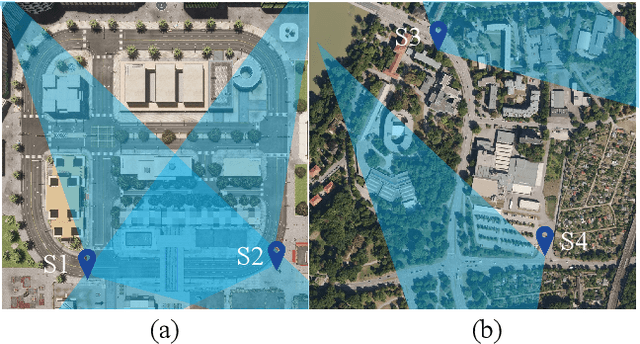
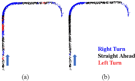

Intelligent Transportation Systems (ITS) can benefit from roadside 4D mmWave radar sensors for large-scale traffic monitoring due to their weatherproof functionality, long sensing range and low manufacturing cost. However, the localization method using external measurement devices has limitations in urban environments. Furthermore, if the sensor mount exhibits changes due to environmental influences, they cannot be corrected when the measurement is performed only during the installation. In this paper, we propose self-localization of roadside radar data using Extended Object Tracking (EOT). The method analyses both the tracked trajectories of the vehicles observed by the sensor and the aerial laser scan of city streets, assigns labels of driving behaviors such as "straight ahead", "left turn", "right turn" to trajectory sections and road segments, and performs Semantic Iterative Closest Points (SICP) algorithm to register the point cloud. The method exploits the result from a down stream task -- object tracking -- for localization. We demonstrate high accuracy in the sub-meter range along with very low orientation error. The method also shows good data efficiency. The evaluation is done in both simulation and real-world tests.
Scalable Radar-based ITS: Self-localization and Occupancy Heat Map for Traffic Analysis
Apr 01, 2024
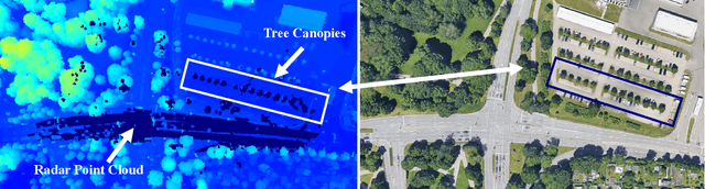
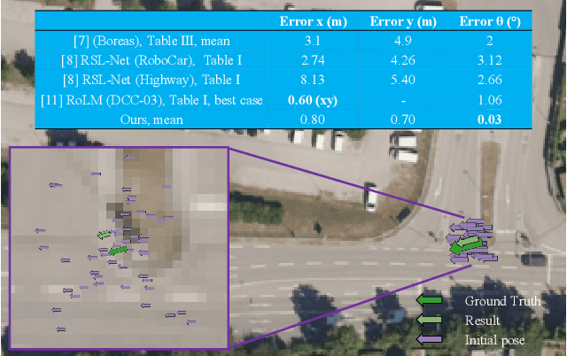
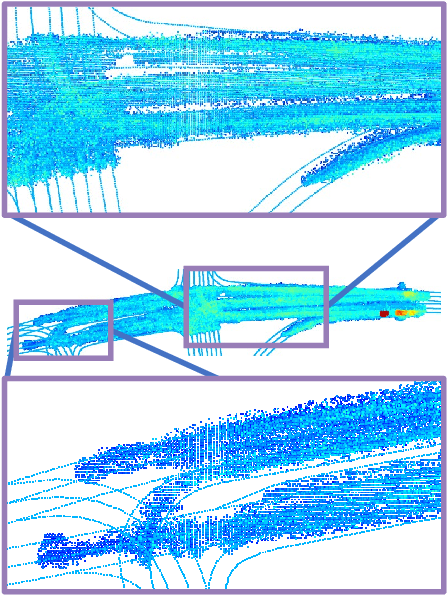
4D mmWave radar sensors are well suited for city scale Intelligent Transportation Systems (ITS) given their long sensing range, weatherproof functionality, simple mechanical design, and low manufacturing cost. In this paper, we investigate radar-based ITS for scalable traffic analysis. Localization of these radar sensors in a city scale range is a fundamental task in ITS. For mobile ITS setups it requires more endeavor. To address this task, we propose a self-localization approach that matches two descriptions of "road": the one from the geometry of the motion trajectories of cumulatively observed vehicles, and the other one from the aerial laser scan. An ICP (iterative closest point) algorithm is used to register the motion trajectory into the road section of the laser scan to estimate the sensor pose. We evaluates the results and show that it outperforms other map-based radar localization methods, especially for the orientation estimation. Beyond the localization result, we project radar sensor data onto city scale laser scan and generate an scalable occupancy heat map as a traffic analysis tool. This is demonstrated using two radar sensors monitoring an urban area in the real world.
Accelerated Real-Life (ARL) Testing and Characterization of Automotive LiDAR Sensors to facilitate the Development and Validation of Enhanced Sensor Models
Dec 07, 2023In the realm of automated driving simulation and sensor modeling, the need for highly accurate sensor models is paramount for ensuring the reliability and safety of advanced driving assistance systems (ADAS). Hence, numerous works focus on the development of high-fidelity models of ADAS sensors, such as camera, Radar as well as modern LiDAR systems to simulate the sensor behavior in different driving scenarios, even under varying environmental conditions, considering for example adverse weather effects. However, aging effects of sensors, leading to suboptimal system performance, are mostly overlooked by current simulation techniques. This paper introduces a cutting-edge Hardware-in-the-Loop (HiL) test bench designed for the automated, accelerated aging and characterization of Automotive LiDAR sensors. The primary objective of this research is to address the aging effects of LiDAR sensors over the product life cycle, specifically focusing on aspects such as laser beam profile deterioration, output power reduction and intrinsic parameter drift, which are mostly neglected in current sensor models. By that, this proceeding research is intended to path the way, not only towards identifying and modeling respective degradation effects, but also to suggest quantitative model validation metrics.