 Add to Chrome
 Add to Firefox
 Add to Edge
Oya: Deep Learning for Accurate Global Precipitation Estimation
Nov 13, 2025Accurate precipitation estimation is critical for hydrological applications, especially in the Global South where ground-based observation networks are sparse and forecasting skill is limited. Existing satellite-based precipitation products often rely on the longwave infrared channel alone or are calibrated with data that can introduce significant errors, particularly at sub-daily timescales. This study introduces Oya, a novel real-time precipitation retrieval algorithm utilizing the full spectrum of visible and infrared (VIS-IR) observations from geostationary (GEO) satellites. Oya employs a two-stage deep learning approach, combining two U-Net models: one for precipitation detection and another for quantitative precipitation estimation (QPE), to address the inherent data imbalance between rain and no-rain events. The models are trained using high-resolution GPM Combined Radar-Radiometer Algorithm (CORRA) v07 data as ground truth and pre-trained on IMERG-Final retrievals to enhance robustness and mitigate overfitting due to the limited temporal sampling of CORRA. By leveraging multiple GEO satellites, Oya achieves quasi-global coverage and demonstrates superior performance compared to existing competitive regional and global precipitation baselines, offering a promising pathway to improved precipitation monitoring and forecasting.
High-Resolution Building and Road Detection from Sentinel-2
Oct 17, 2023


Mapping buildings and roads automatically with remote sensing typically requires high-resolution imagery, which is expensive to obtain and often sparsely available. In this work we demonstrate how multiple 10 m resolution Sentinel-2 images can be used to generate 50 cm resolution building and road segmentation masks. This is done by training a `student' model with access to Sentinel-2 images to reproduce the predictions of a `teacher' model which has access to corresponding high-resolution imagery. While the predictions do not have all the fine detail of the teacher model, we find that we are able to retain much of the performance: for building segmentation we achieve 78.3% mIoU, compared to the high-resolution teacher model accuracy of 85.3% mIoU. We also describe a related method for counting individual buildings in a Sentinel-2 patch which achieves R^2 = 0.91 against true counts. This work opens up new possibilities for using freely available Sentinel-2 imagery for a range of tasks that previously could only be done with high-resolution satellite imagery.
MiNet: A Convolutional Neural Network for Identifying and Categorising Minerals
Nov 22, 2021
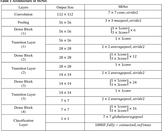
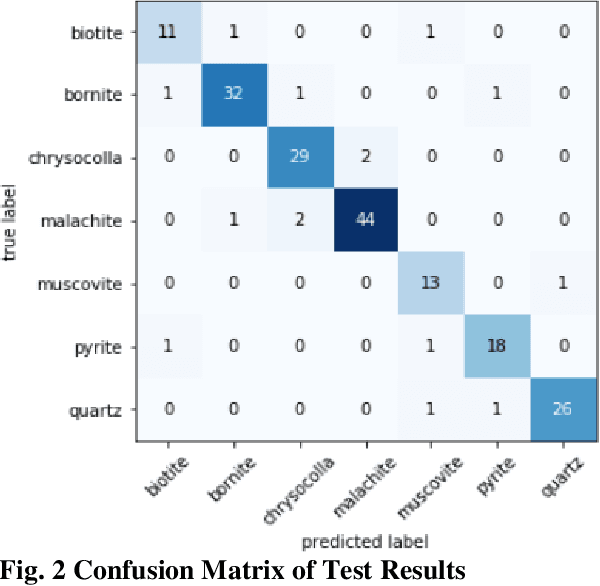
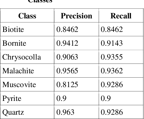
Identification of minerals in the field is a task that is wrought with many challenges. Traditional approaches are prone to errors where there is no enough experience and expertise. Several existing techniques mainly make use of features of the minerals under a microscope and tend to favour a manual feature extraction pipeline. Deep learning methods can help overcome some of these hurdles and provide simple and effective ways to identify minerals. In this paper, we present an algorithm for identifying minerals from hand specimen images. Using a Convolutional Neural Network (CNN), we develop a single-label image classification model to identify and categorise seven classes of minerals. Experiments conducted using real-world datasets show that the model achieves an accuracy of 90.75%.