 Add to Chrome
 Add to Firefox
 Add to Edge
Super-Resolution-based Snake Model -- An Unsupervised Method for Large-Scale Building Extraction using Airborne LiDAR Data and Optical Image
Apr 18, 2020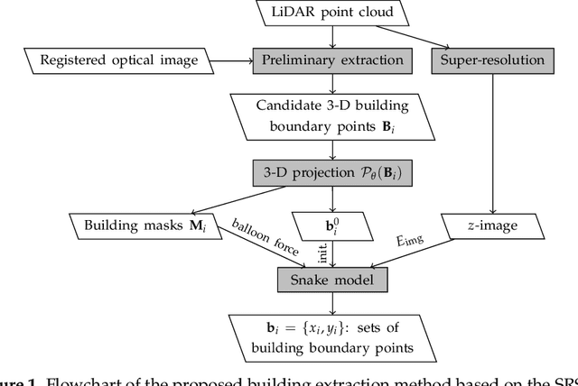
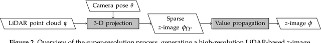
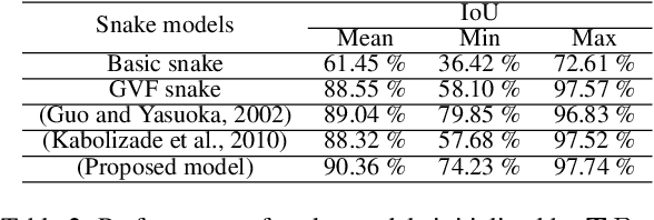
Automatic extraction of buildings in urban and residential scenes has become a subject of growing interest in the domain of photogrammetry and remote sensing, particularly since mid-1990s. Active contour model, colloquially known as snake model, has been studied to extract buildings from aerial and satellite imagery. However, this task is still very challenging due to the complexity of building size, shape, and its surrounding environment. This complexity leads to a major obstacle for carrying out a reliable large-scale building extraction, since the involved prior information and assumptions on building such as shape, size, and color cannot be generalized over large areas. This paper presents an efficient snake model to overcome such challenge, called Super-Resolution-based Snake Model (SRSM). The SRSM operates on high-resolution LiDAR-based elevation images -- called z-images -- generated by a super-resolution process applied to LiDAR data. The involved balloon force model is also improved to shrink or inflate adaptively, instead of inflating the snake continuously. This method is applicable for a large scale such as city scale and even larger, while having a high level of automation and not requiring any prior knowledge nor training data from the urban scenes (hence unsupervised). It achieves high overall accuracy when tested on various datasets. For instance, the proposed SRSM yields an average area-based Quality of 86.57% and object-based Quality of 81.60% on the ISPRS Vaihingen benchmark datasets. Compared to other methods using this benchmark dataset, this level of accuracy is highly desirable even for a supervised method. Similarly desirable outcomes are obtained when carrying out the proposed SRSM on the whole City of Quebec (total area of 656 km2), yielding an area-based Quality of 62.37% and an object-based Quality of 63.21%.
Coarse-to-Fine Registration of Airborne LiDAR Data and Optical Imagery on Urban Scenes
Sep 30, 2019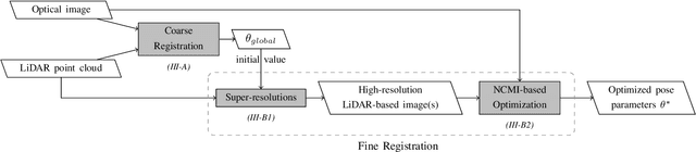
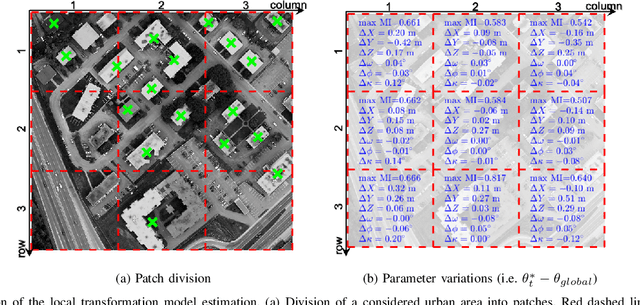
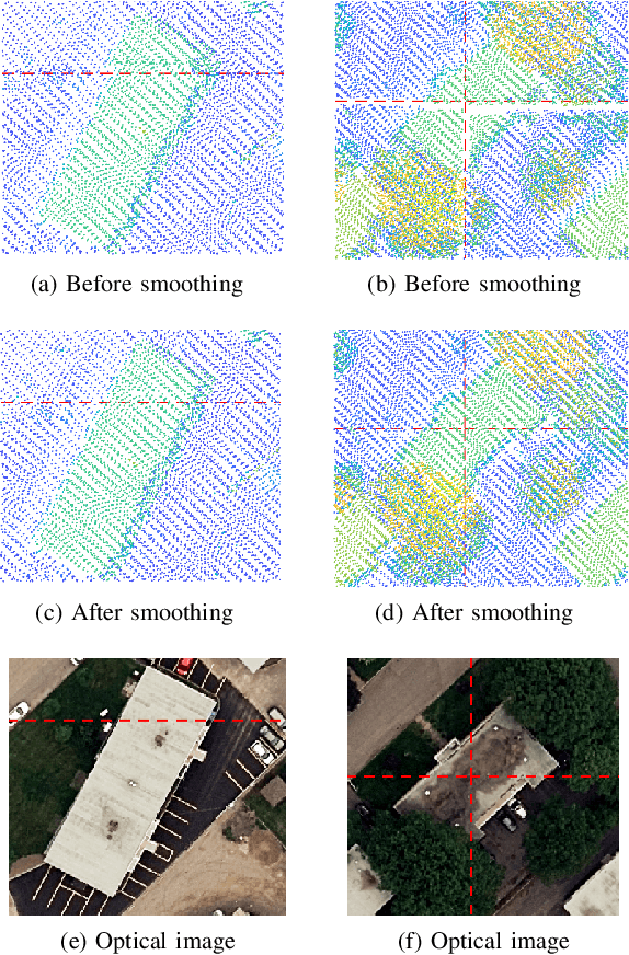
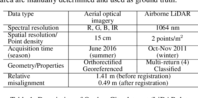
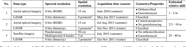
Applications based on synergistic integration of optical imagery and LiDAR data are receiving a growing interest from the remote sensing community. However, a misaligned integration between these datasets may fail to fully profit the potential of both sensors. In this regard, an optimum fusion of optical imagery and LiDAR data requires an accurate registration. This is a complex problem since a versatile solution is still missing, especially when considering the context where data are collected at different times, from different platforms, under different acquisition configurations. This paper presents a coarse-to-fine registration method of aerial/satellite optical imagery with airborne LiDAR data acquired in such context. Firstly, a coarse registration involves extracting and matching of buildings from LiDAR data and optical imagery. Then, a Mutual Information-based fine registration is carried out. It involves a super-resolution approach applied to LiDAR data, and a local approach of transformation model estimation. The proposed method succeeds at overcoming the challenges associated with the aforementioned difficult context. Considering the experimented airborne LiDAR (2011) and orthorectified aerial imagery (2016) datasets, their spatial shift is reduced by 48.15% after the proposed coarse registration. Moreover, the incompatibility of size and spatial resolution is addressed by the mentioned super-resolution. Finally, a high accuracy of dataset alignment is also achieved, highlighted by a 40-cm error based on a check-point assessment and a 64-cm error based on a check-pair-line assessment. These promising results enable further research for a complete versatile fusion methodology between airborne LiDAR and optical imagery data in this challenging context.
Unsupervised Automatic Building Extraction Using Active Contour Model on Unregistered Optical Imagery and Airborne LiDAR Data
Jul 14, 2019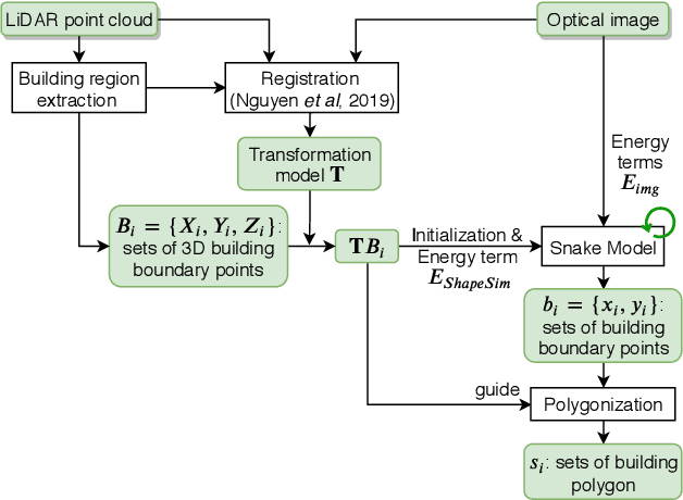
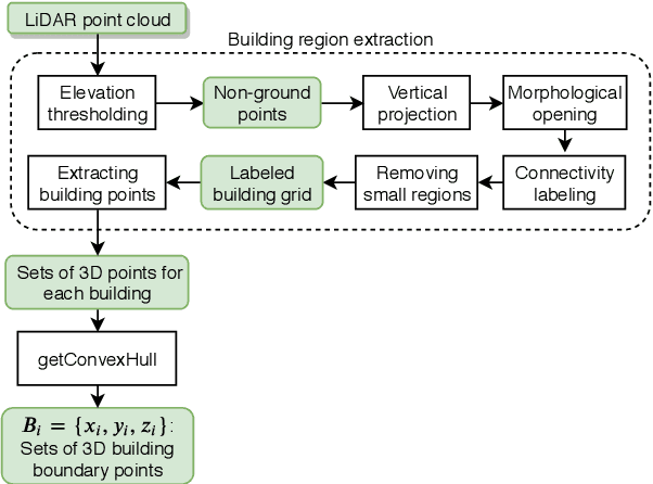
Automatic extraction of buildings in urban scenes has become a subject of growing interest in the domain of photogrammetry and remote sensing, particularly with the emergence of LiDAR systems since mid-1990s. However, in reality, this task is still very challenging due to the complexity of building size and shapes, as well as its surrounding environment. Active contour model, colloquially called snake model, which has been extensively used in many applications in computer vision and image processing, is also applied to extract buildings from aerial/satellite imagery. Motivated by the limitations of existing snake models addressing to the building extraction, this paper presents an unsupervised and fully automatic snake model to extract buildings using optical imagery and an unregistered airborne LiDAR dataset, without manual initial points or training data. The proposed method is shown to be capable of extracting buildings with varying color from complex environments, and yielding high overall accuracy.
Robust Building-based Registration of Airborne LiDAR Data and Optical Imagery on Urban Scenes
Apr 07, 2019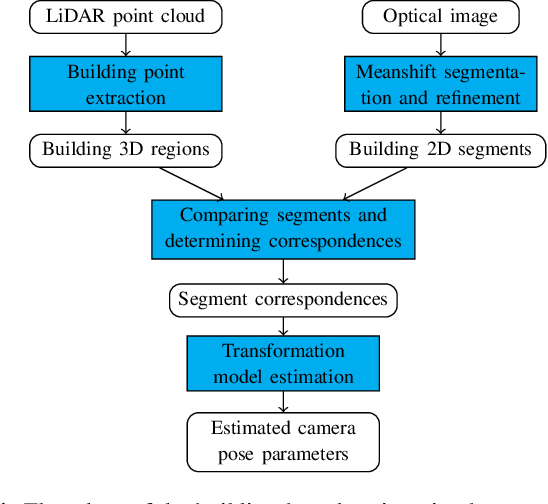
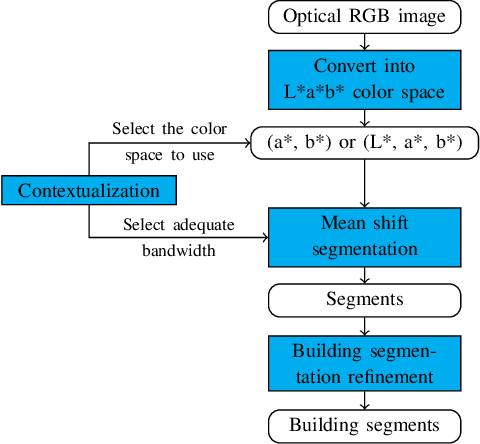
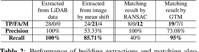
The motivation of this paper is to address the problem of registering airborne LiDAR data and optical aerial or satellite imagery acquired from different platforms, at different times, with different points of view and levels of detail. In this paper, we present a robust registration method based on building regions, which are extracted from optical images using mean shift segmentation, and from LiDAR data using a 3D point cloud filtering process. The matching of the extracted building segments is then carried out using Graph Transformation Matching (GTM) which allows to determine a common pattern of relative positions of segment centers. Thanks to this registration, the relative shifts between the data sets are significantly reduced, which enables a subsequent fine registration and a resulting high-quality data fusion.