 Add to Chrome
 Add to Firefox
 Add to Edge
When One Modality Is Not Enough: Multimodal Sex and Life-Stage Classification of Red Deer from Aerial RGB-Thermal Video
Aug 07, 2026
Aerial drone surveys increasingly support wildlife population estimation, yet a useful census is more than a count: population dynamics are defined by species composition, sex ratios and age structure, that is, by which species are present and how a herd splits into adult males, adult females and juveniles. We use red deer ($\textit{Cervus elaphus}$) as a test case, because managers act on these dynamics and because the visible cue defining adult males, the antlers, is seasonally variable. Surveys are flown nadir, high enough not to disturb the animals, so each deer occupies only a small, low-resolution patch. The two recording modalities fail in opposite conditions: in color a deer under canopy blends into the ground, while in thermal it becomes a bright blob that loses fine detail. Rather than trust either modality alone, we fuse them at every stage using self-supervised DINOv3 features. Our pipeline tracks animals in both modalities, treats an animal as confirmed only when the two cameras agree, keeps only the clear, non-occluded frames, and assigns species and sex by a vote across them; life stage is read separately from geo-referenced body size, since at survey resolution a juvenile often only differs from an adult female in size. Across four flights spanning the antler season the fused pipeline correctly classifies 25 of the 26 detected individuals (7 of 8 adult males, all 16 adult females and 2 juveniles), against 20 of 26 for either sensor alone. Multimodal species classification reaches 96.0%, while for sex classification fusing the two sensors matters most: the combined RGB+thermal model is the most robust across environments and seasons. Automating the demographic classification turns a drone flight from a count into a repeatable reading of herd structure, so the sex ratios and age structure that managers already act on can be gathered as often as a survey can be flown.

Oh Deer, How Should I Handle This? Seasonal Priors for Selective Wildlife Annotation and Classification
Aug 05, 2026Fine-grained wildlife classification in aerial imagery is limited not only by model performance, but also by unreliable labels: animals occupy few pixels, key visual cues vary seasonally, and modality-specific evidence can be ambiguous. We study adult-male identification in red deer, where the antler cycle defines predictable windows of reliable evidence for both annotation and prediction. Using 7,295 RGB-only, thermal-only, and matched RGB+thermal crop sets labeled by three annotators, we show that seasonal structure links (I) annotation quality, (II) downstream classification, and (III) selective prediction. Matched RGB+thermal review resolves more samples than either single modality, recovering majority-male labels otherwise missed by RGB or thermal alone, in human based as well as model based classification. Months with high annotator abstention also show lower classifier confidence, and soft seasonal priors mainly benefit the season-limited thermal view. Uncertainty-band abstention further improves covered accuracy up to 98.9%, though at reduced coverage and with deferral that falls disproportionately on males. Overall, a biologically grounded seasonal calendar predicts where annotation and prediction are unreliable, and can guide both annotation protocol design and modality weighting.
The Way Up: A Dataset for Hold Usage Detection in Sport Climbing
May 19, 2025Detecting an athlete's position on a route and identifying hold usage are crucial in various climbing-related applications. However, no climbing dataset with detailed hold usage annotations exists to our knowledge. To address this issue, we introduce a dataset of 22 annotated climbing videos, providing ground-truth labels for hold locations, usage order, and time of use. Furthermore, we explore the application of keypoint-based 2D pose-estimation models for detecting hold usage in sport climbing. We determine usage by analyzing the key points of certain joints and the corresponding overlap with climbing holds. We evaluate multiple state-of-the-art models and analyze their accuracy on our dataset, identifying and highlighting climbing-specific challenges. Our dataset and results highlight key challenges in climbing-specific pose estimation and establish a foundation for future research toward AI-assisted systems for sports climbing.
Touch Sensing on Semi-Elastic Textiles with Border-Based Sensors
May 17, 2023This study presents a novel approach for touch sensing using semi-elastic textile surfaces that does not require the placement of additional sensors in the sensing area, instead relying on sensors located on the border of the textile. The proposed approach is demonstrated through experiments involving an elastic Jersey fabric and a variety of machine-learning models. The performance of one particular border-based sensor design is evaluated in depth. By using visual markers, the best-performing visual sensor arrangement predicts a single touch point with a mean squared error of 1.36 mm on an area of 125mm by 125mm. We built a textile only prototype that is able to classify touch at three indent levels (0, 15, and 20 mm) with an accuracy of 82.85%. Our results suggest that this approach has potential applications in wearable technology and smart textiles, making it a promising avenue for further exploration in these fields.
Through-Foliage Tracking with Airborne Optical Sectioning
Nov 30, 2021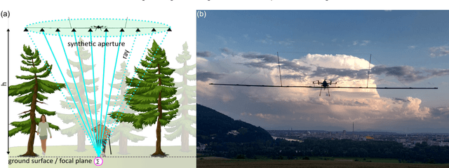
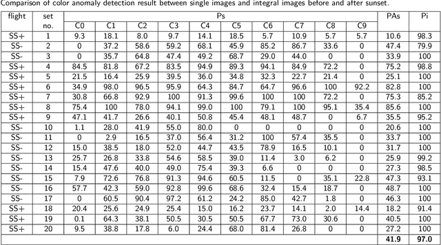
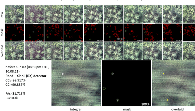
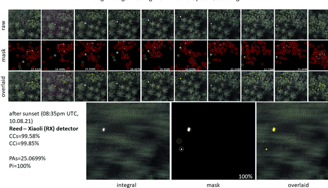
Detecting and tracking moving targets through foliage is difficult, and for many cases even impossible in regular aerial images and videos. We present an initial light-weight and drone-operated 1D camera array that supports parallel synthetic aperture aerial imaging. Our main finding is that color anomaly detection benefits significantly from image integration when compared to conventional raw images or video frames (on average 97% vs. 42% in precision in our field experiments). We demonstrate, that these two contributions can lead to the detection and tracking of moving people through densely occluding forest.
Combined Person Classification with Airborne Optical Sectioning
Jun 18, 2021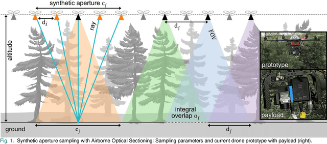
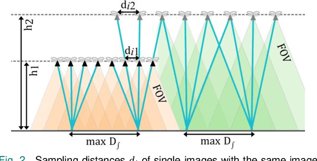
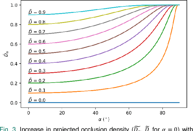
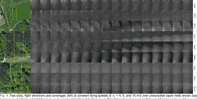
Fully autonomous drones have been demonstrated to find lost or injured persons under strongly occluding forest canopy. Airborne Optical Sectioning (AOS), a novel synthetic aperture imaging technique, together with deep-learning-based classification enables high detection rates under realistic search-and-rescue conditions. We demonstrate that false detections can be significantly suppressed and true detections boosted by combining classifications from multiple AOS rather than single integral images. This improves classification rates especially in the presence of occlusion. To make this possible, we modified the AOS imaging process to support large overlaps between subsequent integrals, enabling real-time and on-board scanning and processing of groundspeeds up to 10 m/s.
Pose Error Reduction for Focus Enhancement in Thermal Synthetic Aperture Visualization
Dec 15, 2020Airborne optical sectioning, an effective aerial synthetic aperture imaging technique for revealing artifacts occluded by forests, requires precise measurements of drone poses. In this article we present a new approach for reducing pose estimation errors beyond the possibilities of conventional Perspective-n-Point solutions by considering the underlying optimization as a focusing problem. We present an efficient image integration technique, which also reduces the parameter search space to achieve realistic processing times, and improves the quality of resulting synthetic integral images.
Search and Rescue with Airborne Optical Sectioning
Sep 18, 2020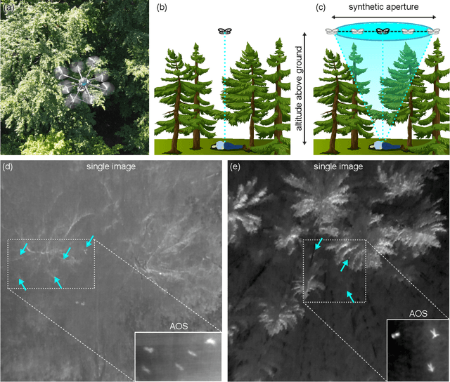
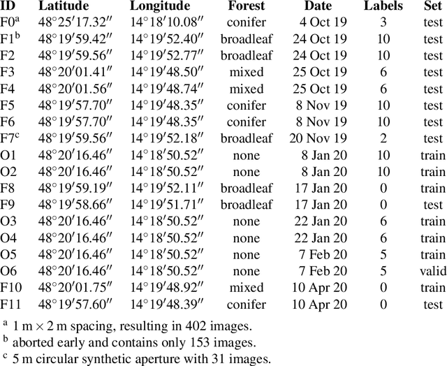
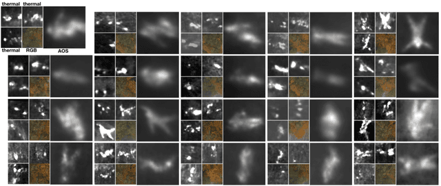
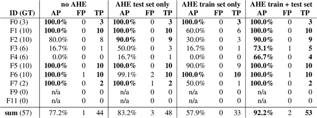
We show that automated person detection under occlusion conditions can be significantly improved by combining multi-perspective images before classification. Here, we employed image integration by Airborne Optical Sectioning (AOS)---a synthetic aperture imaging technique that uses camera drones to capture unstructured thermal light fields---to achieve this with a precision/recall of 96/93%. Finding lost or injured people in dense forests is not generally feasible with thermal recordings, but becomes practical with use of AOS integral images. Our findings lay the foundation for effective future search and rescue technologies that can be applied in combination with autonomous or manned aircraft. They can also be beneficial for other fields that currently suffer from inaccurate classification of partially occluded people, animals, or objects.
Fast Automatic Visibility Optimization for Thermal Synthetic Aperture Visualization
May 08, 2020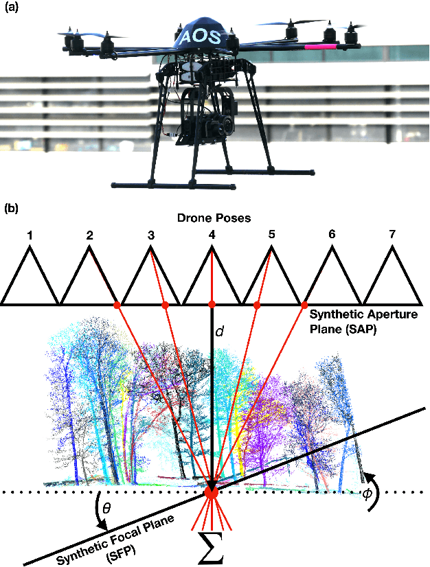
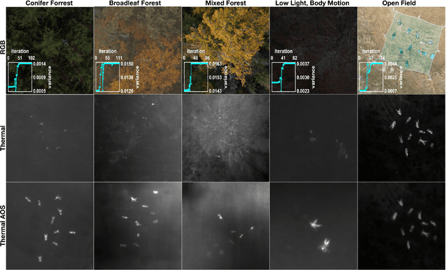
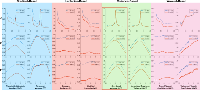
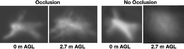
In this article, we describe and validate the first fully automatic parameter optimization for thermal synthetic aperture visualization. It replaces previous manual exploration of the parameter space, which is time consuming and error prone. We prove that the visibility of targets in thermal integral images is proportional to the variance of the targets' image. Since this is invariant to occlusion it represents a suitable objective function for optimization. Our findings have the potential to enable fully autonomous search and recuse operations with camera drones.
A Statistical View on Synthetic Aperture Imaging for Occlusion Removal
Jun 15, 2019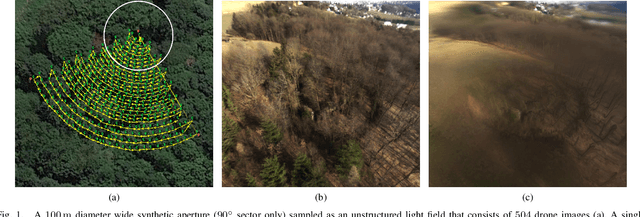
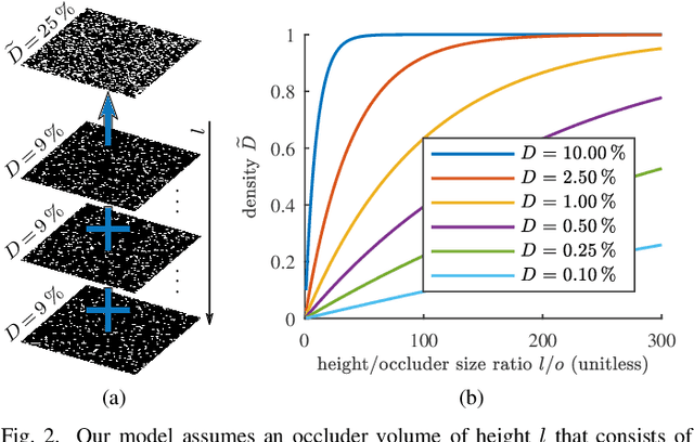
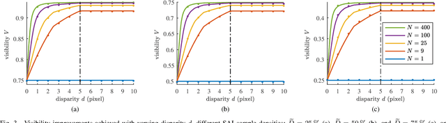
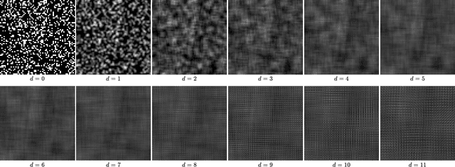
Synthetic apertures find applications in many fields, such as radar, radio telescopes, microscopy, sonar, ultrasound, LiDAR, and optical imaging. They approximate the signal of a single hypothetical wide aperture sensor with either an array of static small aperture sensors or a single moving small aperture sensor. Common sense in synthetic aperture sampling is that a dense sampling pattern within a wide aperture is required to reconstruct a clear signal. In this article we show that there exists practical limits to both, synthetic aperture size and number of samples for the application of occlusion removal. This leads to an understanding on how to design synthetic aperture sampling patterns and sensors in a most optimal and practically efficient way. We apply our findings to airborne optical sectioning which uses camera drones and synthetic aperture imaging to computationally remove occluding vegetation or trees for inspecting ground surfaces.