 Add to Chrome
 Add to Firefox
 Add to Edge
How accurate are existing land cover maps for agriculture in Sub-Saharan Africa?
Jul 05, 2023Satellite Earth observations (EO) can provide affordable and timely information for assessing crop conditions and food production. Such monitoring systems are essential in Africa, where there is high food insecurity and sparse agricultural statistics. EO-based monitoring systems require accurate cropland maps to provide information about croplands, but there is a lack of data to determine which of the many available land cover maps most accurately identify cropland in African countries. This study provides a quantitative evaluation and intercomparison of 11 publicly available land cover maps to assess their suitability for cropland classification and EO-based agriculture monitoring in Africa using statistically rigorous reference datasets from 8 countries. We hope the results of this study will help users determine the most suitable map for their needs and encourage future work to focus on resolving inconsistencies between maps and improving accuracy in low-accuracy regions.
Using transfer learning to study burned area dynamics: A case study of refugee settlements in West Nile, Northern Uganda
Jul 29, 2021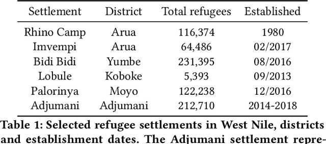
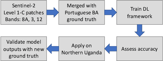
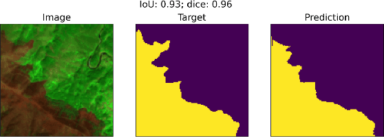
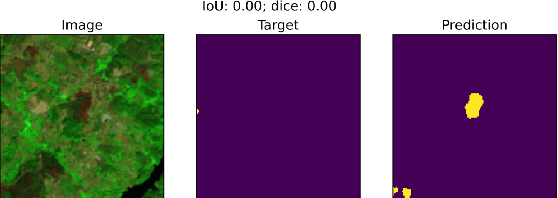
With the global refugee crisis at a historic high, there is a growing need to assess the impact of refugee settlements on their hosting countries and surrounding environments. Because fires are an important land management practice in smallholder agriculture in sub-Saharan Africa, burned area (BA) mappings can help provide information about the impacts of land management practices on local environments. However, a lack of BA ground-truth data in much of sub-Saharan Africa limits the use of highly scalable deep learning (DL) techniques for such BA mappings. In this work, we propose a scalable transfer learning approach to study BA dynamics in areas with little to no ground-truth data such as the West Nile region in Northern Uganda. We train a deep learning model on BA ground-truth data in Portugal and propose the application of that model on refugee-hosting districts in West Nile between 2015 and 2020. By comparing the district-level BA dynamic with the wider West Nile region, we aim to add understanding of the land management impacts of refugee settlements on their surrounding environments.
Rapid Response Crop Maps in Data Sparse Regions
Jun 23, 2020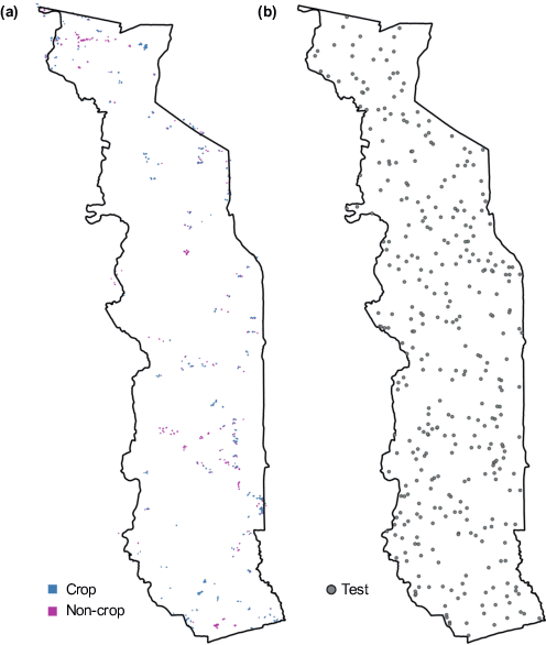
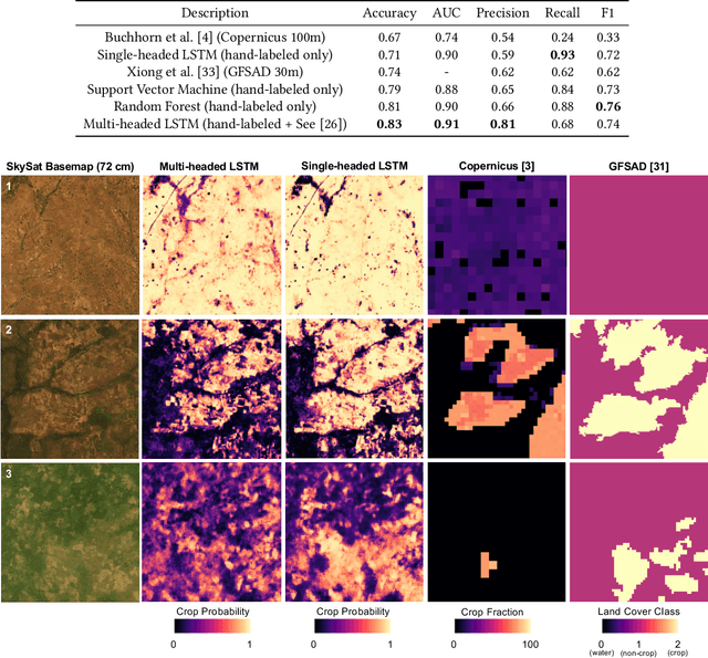
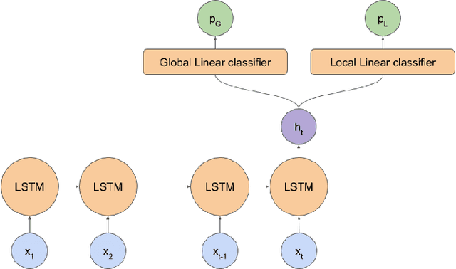
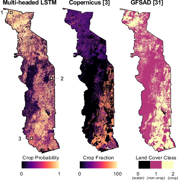
Spatial information on cropland distribution, often called cropland or crop maps, are critical inputs for a wide range of agriculture and food security analyses and decisions. However, high-resolution cropland maps are not readily available for most countries, especially in regions dominated by smallholder farming (e.g., sub-Saharan Africa). These maps are especially critical in times of crisis when decision makers need to rapidly design and enact agriculture-related policies and mitigation strategies, including providing humanitarian assistance, dispersing targeted aid, or boosting productivity for farmers. A major challenge for developing crop maps is that many regions do not have readily accessible ground truth data on croplands necessary for training and validating predictive models, and field campaigns are not feasible for collecting labels for rapid response. We present a method for rapid mapping of croplands in regions where little to no ground data is available. We present results for this method in Togo, where we delivered a high-resolution (10 m) cropland map in under 10 days to facilitate rapid response to the COVID-19 pandemic by the Togolese government. This demonstrated a successful transition of machine learning applications research to operational rapid response in a real humanitarian crisis. All maps, data, and code are publicly available to enable future research and operational systems in data-sparse regions.
Field-Level Crop Type Classification with k Nearest Neighbors: A Baseline for a New Kenya Smallholder Dataset
Apr 06, 2020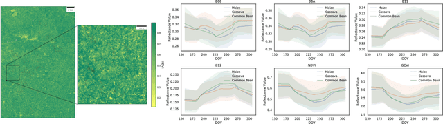
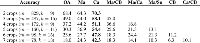
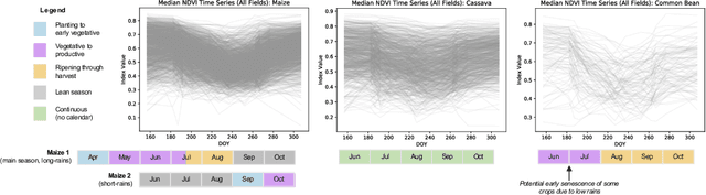
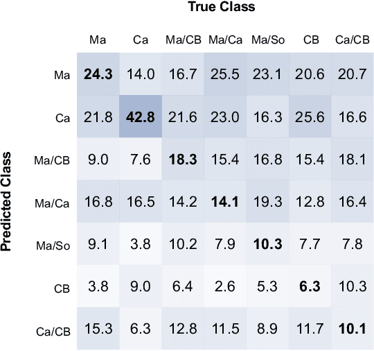
Accurate crop type maps provide critical information for ensuring food security, yet there has been limited research on crop type classification for smallholder agriculture, particularly in sub-Saharan Africa where risk of food insecurity is highest. Publicly-available ground-truth data such as the newly-released training dataset of crop types in Kenya (Radiant MLHub) are catalyzing this research, but it is important to understand the context of when, where, and how these datasets were obtained when evaluating classification performance and using them as a benchmark across methods. In this paper, we provide context for the new western Kenya dataset which was collected during an atypical 2019 main growing season and demonstrate classification accuracy up to 64% for maize and 70% for cassava using k Nearest Neighbors--a fast, interpretable, and scalable method that can serve as a baseline for future work.