 Add to Chrome
 Add to Firefox
 Add to Edge
Microscopic Vehicle Trajectory Datasets from UAV-collected Video for Heterogeneous, Area-Based Urban Traffic
Dec 10, 2025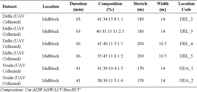
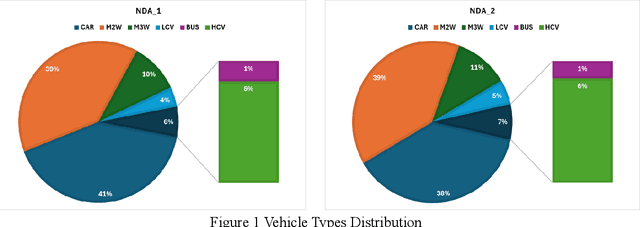
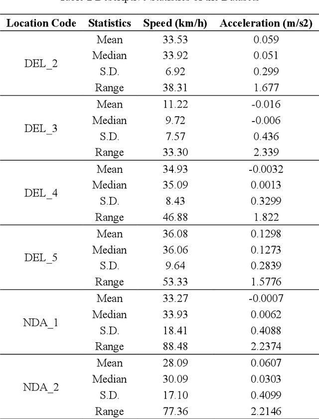
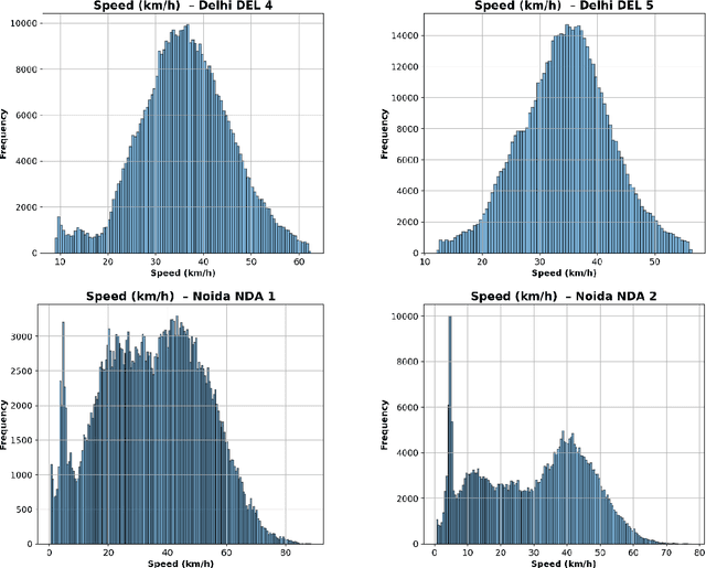
This paper offers openly available microscopic vehicle trajectory (MVT) datasets collected using unmanned aerial vehicles (UAVs) in heterogeneous, area-based urban traffic conditions. Traditional roadside video collection often fails in dense mixed traffic due to occlusion, limited viewing angles, and irregular vehicle movements. UAV-based recording provides a top-down perspective that reduces these issues and captures rich spatial and temporal dynamics. The datasets described here were extracted using the Data from Sky (DFS) platform and validated against manual counts, space mean speeds, and probe trajectories in earlier work. Each dataset contains time-stamped vehicle positions, speeds, longitudinal and lateral accelerations, and vehicle classifications at a resolution of 30 frames per second. Data were collected at six mid-block locations in the national capital region of India, covering diverse traffic compositions and density levels. Exploratory analyses highlight key behavioural patterns, including lane-keeping preferences, speed distributions, and lateral manoeuvres typical of heterogeneous and area-based traffic settings. These datasets are intended as a resource for the global research community to support simulation modelling, safety assessment, and behavioural studies under area-based traffic conditions. By making these empirical datasets openly available, this work offers researchers a unique opportunity to develop, test, and validate models that more accurately represent complex urban traffic environments.
Scrutinizing Data from Sky: An Examination of Its Veracity in Area Based Traffic Contexts
Apr 26, 2024


Traffic data collection has been an overwhelming task for researchers as well as authorities over the years. With the advancement in technology and introduction of various tools for processing and extracting traffic data the task has been made significantly convenient. Data from Sky (DFS) is one such tool, based on image processing and artificial intelligence (AI), that provides output for macroscopic as well as microscopic variables of the traffic streams. The company claims to provide 98 to 100 percent accuracy on the data exported using DFS tool. The tool is widely used in developed countries where the traffic is homogenous and has lane-based movements. In this study, authors have checked the veracity of DFS tool in heterogenous and area-based traffic movement that is prevailing in most developing countries. The validation is done using various methods using Classified Volume Count (CVC), Space Mean Speeds (SMS) of individual vehicle classes and microscopic trajectory of probe vehicle to verify DFS claim. The error for CVCs for each vehicle class present in the traffic stream is estimated. Mean Absolute Percentage Error (MAPE) values are calculated for average speeds of each vehicle class between manually and DFS extracted space mean speeds (SMSs), and the microscopic trajectories are validated using a GPS based tracker put on probe vehicles. The results are fairly accurate in the case of data taken from a bird eye view with least errors. The other configurations of data collection have some significant errors, that are majorly caused by the varied traffic composition, the view of camera angle, and the direction of traffic.