 Add to Chrome
 Add to Firefox
 Add to Edge
Cross-Domain Dead Tree Detection via Knowledge Distillation in Aerial Imagery
Jun 01, 2026Detecting dead trees in aerial imagery is vital for assessing forest health, especially as tree mortality increases globally due to climate change, but domain variability and scarce labeled data often limit model generalization. This study advances the TreeMort-1T-UNet (Tree Mortality 1-Task U-Net) model, initially trained on Finnish aerial imagery (source domain), by applying knowledge distillation (KD) to adapt it to various target domains, including Polish, German, and Estonian datasets representing diverse forest types. We assess four KD variants: Basic, Self, Feature-level, and Ensemble, against a fine-tuning baseline, using Mean Tree IoU, Instance F1-score, Instance Precision, and Mean Centroid Error as key metrics, alongside representational analyses (e.g., cosine similarity, CKA, SSIM, t-SNE, and linear probing) for domain invariance. Feature-level KD outperforms others, yielding a Mean Tree IoU of 0.106, Instance F1-score of 0.63, Instance Precision of 0.55, and Mean Centroid Error of 3.039 on the Polish dataset, with robust precision across other target domains (e.g., 0.15 on Finnish, 0.67 on Polish, 0.60 on German, 0.59 on Estonian). It excels in low-data scenarios with fewer false positives and shows superior representational invariance (e.g., higher deep-layer CKA/SSIM, better domain mixing in t-SNE, and linear probing AUC of 0.95), making it ideal for precision-critical forestry applications. Additional ablation studies confirm that key components like feature alignment enhance its performance balance across metrics. Our findings demonstrate KD's potential to enhance transfer learning in remote sensing, offering a scalable, domain-robust tool for ecological monitoring and sustainable forest management.
Multispectral Blind Image Super-Resolution for Standing Dead Tree Segmentation
May 04, 2026Mapping standing dead trees is crucial for acquiring information on the effects of climate change on forests and forest biodiversity. However, leveraging high-quality aerial imagery for dead tree segmentation poses challenges due to limitations in sensor availability and the scarcity of annotated data. In this study, we propose a generic blind super-resolution framework that incorporates Attention-Guided Domain Adaptation Networks (ADA-Nets) to learn the mapping from low-resolution to high-resolution multispectral image domains. Our approach operates solely on unpaired samples, mimicking real-world conditions, i.e., low-resolution images are not synthetically obtained by downsampling the high-resolution images. Moreover, the proposed method serves as a general-purpose restorer addressing several image degradation types, including saturation, noise, and low contrast that typically occur in low-resolution images acquired by low-end sensors. To the best of our knowledge, this is the first study to perform real-world and generic super-resolution for multispectral data in the scope of standing dead tree segmentation. Experimental evaluations demonstrate segmentation performances of 54% and 64% in Dice scores. Notably, the first result is obtained without using any high-resolution annotations; the segmentation network is trained on super-resolved low-resolution images, while evaluation is performed on the high-resolution data. We publicly share the aerial multispectral dataset with manually annotated labels at https://www.kaggle.com/datasets/meteahishali/aerial-imagery-for-dead-tree-segmentation-poland.
ADA-Net: Attention-Guided Domain Adaptation Network with Contrastive Learning for Standing Dead Tree Segmentation Using Aerial Imagery
Apr 05, 2025Information on standing dead trees is important for understanding forest ecosystem functioning and resilience but has been lacking over large geographic regions. Climate change has caused large-scale tree mortality events that can remain undetected due to limited data. In this study, we propose a novel method for segmenting standing dead trees using aerial multispectral orthoimages. Because access to annotated datasets has been a significant problem in forest remote sensing due to the need for forest expertise, we introduce a method for domain transfer by leveraging domain adaptation to learn a transformation from a source domain X to target domain Y. In this Image-to-Image translation task, we aim to utilize available annotations in the target domain by pre-training a segmentation network. When images from a new study site without annotations are introduced (source domain X), these images are transformed into the target domain. Then, transfer learning is applied by inferring the pre-trained network on domain-adapted images. In addition to investigating the feasibility of current domain adaptation approaches for this objective, we propose a novel approach called the Attention-guided Domain Adaptation Network (ADA-Net) with enhanced contrastive learning. Accordingly, the ADA-Net approach provides new state-of-the-art domain adaptation performance levels outperforming existing approaches. We have evaluated the proposed approach using two datasets from Finland and the US. The USA images are converted to the Finland domain, and we show that the synthetic USA2Finland dataset exhibits similar characteristics to the Finland domain images. The software implementation is shared at https://github.com/meteahishali/ADA-Net. The data is publicly available at https://www.kaggle.com/datasets/meteahishali/aerial-imagery-for-standing-dead-tree-segmentation.
Dual-Task Learning for Dead Tree Detection and Segmentation with Hybrid Self-Attention U-Nets in Aerial Imagery
Mar 27, 2025Mapping standing dead trees is critical for assessing forest health, monitoring biodiversity, and mitigating wildfire risks, for which aerial imagery has proven useful. However, dense canopy structures, spectral overlaps between living and dead vegetation, and over-segmentation errors limit the reliability of existing methods. This study introduces a hybrid postprocessing framework that refines deep learning-based tree segmentation by integrating watershed algorithms with adaptive filtering, enhancing boundary delineation, and reducing false positives in complex forest environments. Tested on high-resolution aerial imagery from boreal forests, the framework improved instance-level segmentation accuracy by 41.5% and reduced positional errors by 57%, demonstrating robust performance in densely vegetated regions. By balancing detection accuracy and over-segmentation artifacts, the method enabled the precise identification of individual dead trees, which is critical for ecological monitoring. The framework's computational efficiency supports scalable applications, such as wall-to-wall tree mortality mapping over large geographic regions using aerial or satellite imagery. These capabilities directly benefit wildfire risk assessment (identifying fuel accumulations), carbon stock estimation (tracking emissions from decaying biomass), and precision forestry (targeting salvage loggings). By bridging advanced remote sensing techniques with practical forest management needs, this work advances tools for large-scale ecological conservation and climate resilience planning.
Deep dual stream residual network with contextual attention for pansharpening of remote sensing images
Jul 25, 2022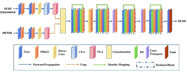
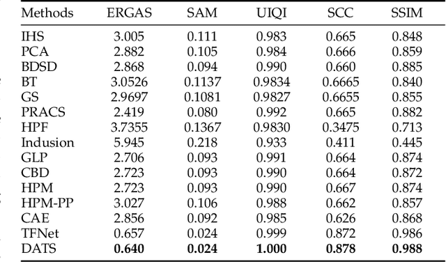
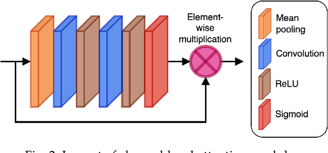
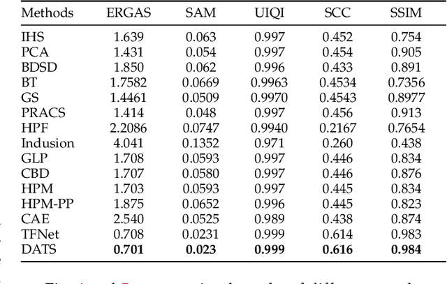
Pansharpening enhances spatial details of high spectral resolution multispectral images using features of high spatial resolution panchromatic image. There are a number of traditional pansharpening approaches but producing an image exhibiting high spectral and spatial fidelity is still an open problem. Recently, deep learning has been used to produce promising pansharpened images; however, most of these approaches apply similar treatment to both multispectral and panchromatic images by using the same network for feature extraction. In this work, we present present a novel dual attention-based two-stream network. It starts with feature extraction using two separate networks for both images, an encoder with attention mechanism to recalibrate the extracted features. This is followed by fusion of the features forming a compact representation fed into an image reconstruction network to produce a pansharpened image. The experimental results on the Pl\'{e}iades dataset using standard quantitative evaluation metrics and visual inspection demonstrates that the proposed approach performs better than other approaches in terms of pansharpened image quality.
Audiovisual Saliency Prediction in Uncategorized Video Sequences based on Audio-Video Correlation
Jan 07, 2021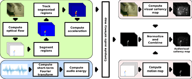
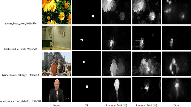
Substantial research has been done in saliency modeling to develop intelligent machines that can perceive and interpret their surroundings. But existing models treat videos as merely image sequences excluding any audio information, unable to cope with inherently varying content. Based on the hypothesis that an audiovisual saliency model will be an improvement over traditional saliency models for natural uncategorized videos, this work aims to provide a generic audio/video saliency model augmenting a visual saliency map with an audio saliency map computed by synchronizing low-level audio and visual features. The proposed model was evaluated using different criteria against eye fixations data for a publicly available DIEM video dataset. The results show that the model outperformed two state-of-the-art visual saliency models.