 Add to Chrome
 Add to Firefox
 Add to Edge
Multimodal Masked Autoencoder Pre-training for 3D MRI-Based Brain Tumor Analysis with Missing Modalities
May 01, 2025


Multimodal magnetic resonance imaging (MRI) constitutes the first line of investigation for clinicians in the care of brain tumors, providing crucial insights for surgery planning, treatment monitoring, and biomarker identification. Pre-training on large datasets have been shown to help models learn transferable representations and adapt with minimal labeled data. This behavior is especially valuable in medical imaging, where annotations are often scarce. However, applying this paradigm to multimodal medical data introduces a challenge: most existing approaches assume that all imaging modalities are available during both pre-training and fine-tuning. In practice, missing modalities often occur due to acquisition issues, specialist unavailability, or specific experimental designs on small in-house datasets. Consequently, a common approach involves training a separate model for each desired modality combination, making the process both resource-intensive and impractical for clinical use. Therefore, we introduce BM-MAE, a masked image modeling pre-training strategy tailored for multimodal MRI data. The same pre-trained model seamlessly adapts to any combination of available modalities, extracting rich representations that capture both intra- and inter-modal information. This allows fine-tuning on any subset of modalities without requiring architectural changes, while still benefiting from a model pre-trained on the full set of modalities. Extensive experiments show that the proposed pre-training strategy outperforms or remains competitive with baselines that require separate pre-training for each modality subset, while substantially surpassing training from scratch on several downstream tasks. Additionally, it can quickly and efficiently reconstruct missing modalities, highlighting its practical value. Code and trained models are available at: https://github.com/Lucas-rbnt/bmmae
Uncovering the Genetic Basis of Glioblastoma Heterogeneity through Multimodal Analysis of Whole Slide Images and RNA Sequencing Data
Oct 23, 2024Glioblastoma is a highly aggressive form of brain cancer characterized by rapid progression and poor prognosis. Despite advances in treatment, the underlying genetic mechanisms driving this aggressiveness remain poorly understood. In this study, we employed multimodal deep learning approaches to investigate glioblastoma heterogeneity using joint image/RNA-seq analysis. Our results reveal novel genes associated with glioblastoma. By leveraging a combination of whole-slide images and RNA-seq, as well as introducing novel methods to encode RNA-seq data, we identified specific genetic profiles that may explain different patterns of glioblastoma progression. These findings provide new insights into the genetic mechanisms underlying glioblastoma heterogeneity and highlight potential targets for therapeutic intervention.
DRIM: Learning Disentangled Representations from Incomplete Multimodal Healthcare Data
Sep 25, 2024Real-life medical data is often multimodal and incomplete, fueling the growing need for advanced deep learning models capable of integrating them efficiently. The use of diverse modalities, including histopathology slides, MRI, and genetic data, offers unprecedented opportunities to improve prognosis prediction and to unveil new treatment pathways. Contrastive learning, widely used for deriving representations from paired data in multimodal tasks, assumes that different views contain the same task-relevant information and leverages only shared information. This assumption becomes restrictive when handling medical data since each modality also harbors specific knowledge relevant to downstream tasks. We introduce DRIM, a new multimodal method for capturing these shared and unique representations, despite data sparsity. More specifically, given a set of modalities, we aim to encode a representation for each one that can be divided into two components: one encapsulating patient-related information common across modalities and the other, encapsulating modality-specific details. This is achieved by increasing the shared information among different patient modalities while minimizing the overlap between shared and unique components within each modality. Our method outperforms state-of-the-art algorithms on glioma patients survival prediction tasks, while being robust to missing modalities. To promote reproducibility, the code is made publicly available at https://github.com/Lucas-rbnt/DRIM
Continual learning using hash-routed convolutional neural networks
Oct 09, 2020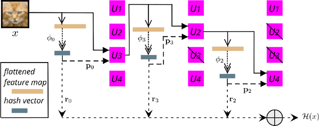
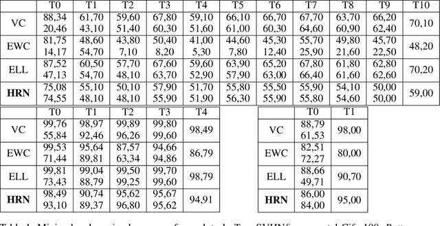
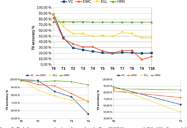
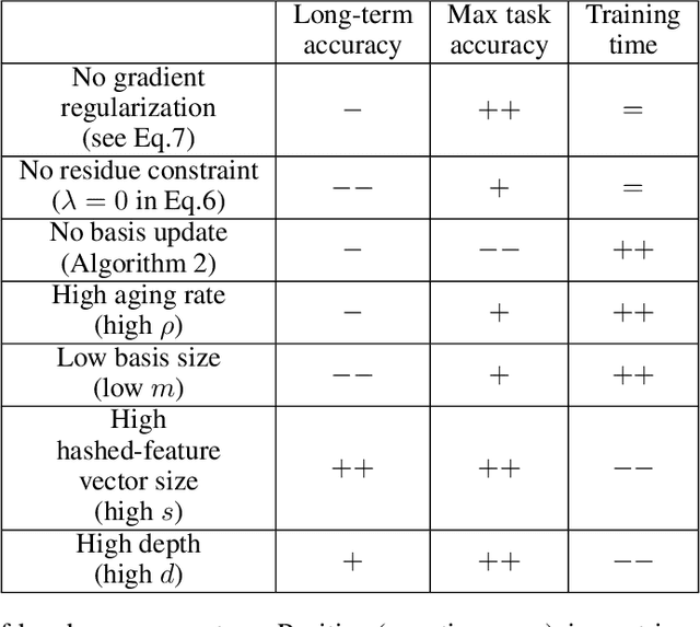
Continual learning could shift the machine learning paradigm from data centric to model centric. A continual learning model needs to scale efficiently to handle semantically different datasets, while avoiding unnecessary growth. We introduce hash-routed convolutional neural networks: a group of convolutional units where data flows dynamically. Feature maps are compared using feature hashing and similar data is routed to the same units. A hash-routed network provides excellent plasticity thanks to its routed nature, while generating stable features through the use of orthogonal feature hashing. Each unit evolves separately and new units can be added (to be used only when necessary). Hash-routed networks achieve excellent performance across a variety of typical continual learning benchmarks without storing raw data and train using only gradient descent. Besides providing a continual learning framework for supervised tasks with encouraging results, our model can be used for unsupervised or reinforcement learning.
Scientific image rendering for space scenes with the SurRender software
Oct 02, 2018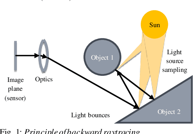
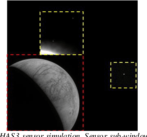
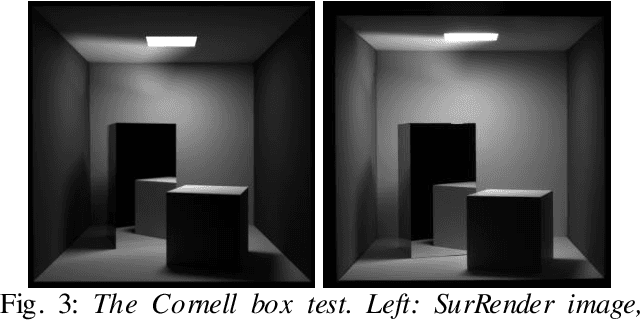
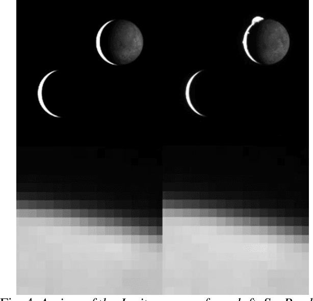
Spacecraft autonomy can be enhanced by vision-based navigation (VBN) techniques. Applications range from manoeuvers around Solar System objects and landing on planetary surfaces, to in-orbit servicing or space debris removal. The development and validation of VBN algorithms relies on the availability of physically accurate relevant images. Yet archival data from past missions can rarely serve this purpose and acquiring new data is often costly. The SurRender software is an image simulator that addresses the challenges of realistic image rendering, with high representativeness for space scenes. Images are rendered by raytracing, which implements the physical principles of geometrical light propagation, in physical units. A macroscopic instrument model and scene objects reflectance functions are used. SurRender is specially optimized for space scenes, with huge distances between objects and scenes up to Solar System size. Raytracing conveniently tackles some important effects for VBN algorithms: image quality, eclipses, secondary illumination, subpixel limb imaging, etc. A simulation is easily setup (in MATLAB, Python, and more) by specifying the position of the bodies (camera, Sun, planets, satellites) over time, 3D shapes and material surface properties. SurRender comes with its own modelling tool enabling to go beyond existing models for shapes, materials and sensors (projection, temporal sampling, electronics, etc.). It is natively designed to simulate different kinds of sensors (visible, LIDAR, etc.). Tools are available for manipulating huge datasets to store albedo maps and digital elevation models, or for procedural (fractal) texturing that generates high-quality images for a large range of observing distances (from millions of km to touchdown). We illustrate SurRender performances with a selection of case studies, placing particular emphasis on a 900-km Moon flyby simulation.