 Add to Chrome
 Add to Firefox
 Add to Edge
Incremental Learning for Semantic Segmentation of Large-Scale Remote Sensing Data
Oct 29, 2018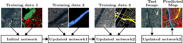
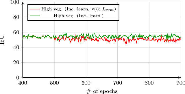
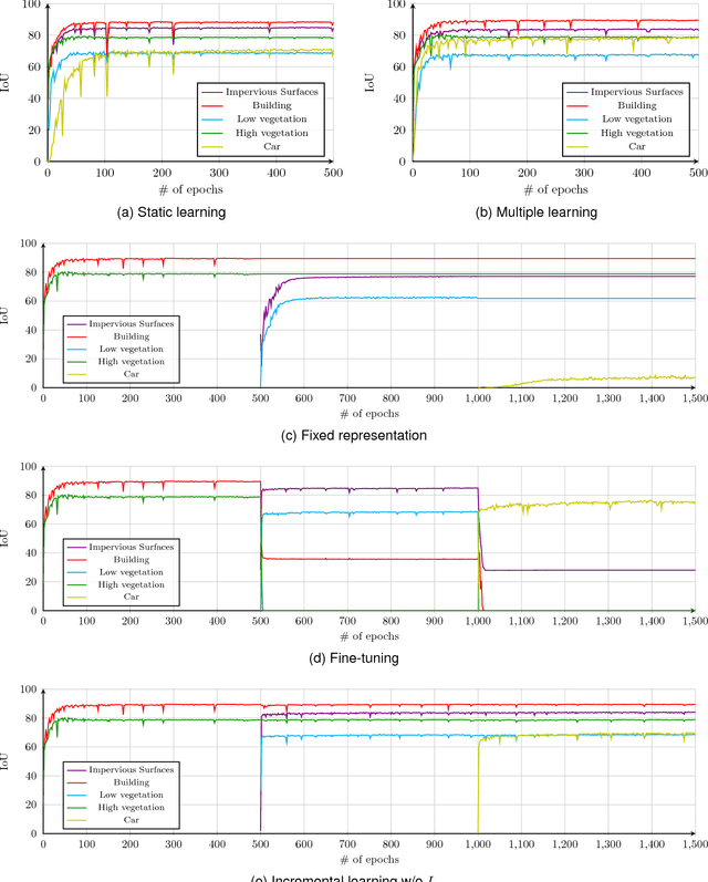
In spite of remarkable success of the convolutional neural networks on semantic segmentation, they suffer from catastrophic forgetting: a significant performance drop for the already learned classes when new classes are added on the data, having no annotations for the old classes. We propose an incremental learning methodology, enabling to learn segmenting new classes without hindering dense labeling abilities for the previous classes, although the entire previous data are not accessible. The key points of the proposed approach are adapting the network to learn new as well as old classes on the new training data, and allowing it to remember the previously learned information for the old classes. For adaptation, we keep a frozen copy of the previously trained network, which is used as a memory for the updated network in absence of annotations for the former classes. The updated network minimizes a loss function, which balances the discrepancy between outputs for the previous classes from the memory and updated networks, and the mis-classification rate between outputs for the new classes from the updated network and the new ground-truth. For remembering, we either regularly feed samples from the stored, little fraction of the previous data or use the memory network, depending on whether the new data are collected from completely different geographic areas or from the same city. Our experimental results prove that it is possible to add new classes to the network, while maintaining its performance for the previous classes, despite the whole previous training data are not available.
Coarse to fine non-rigid registration: a chain of scale-specific neural networks for multimodal image alignment with application to remote sensing
Feb 27, 2018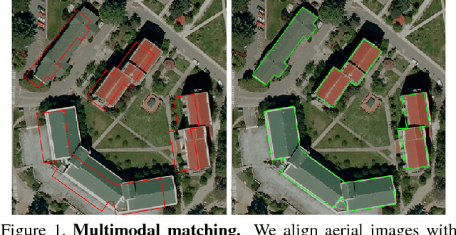
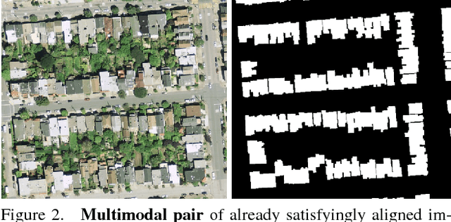
We tackle here the problem of multimodal image non-rigid registration, which is of prime importance in remote sensing and medical imaging. The difficulties encountered by classical registration approaches include feature design and slow optimization by gradient descent. By analyzing these methods, we note the significance of the notion of scale. We design easy-to-train, fully-convolutional neural networks able to learn scale-specific features. Once chained appropriately, they perform global registration in linear time, getting rid of gradient descent schemes by predicting directly the deformation.We show their performance in terms of quality and speed through various tasks of remote sensing multimodal image alignment. In particular, we are able to register correctly cadastral maps of buildings as well as road polylines onto RGB images, and outperform current keypoint matching methods.
Recurrent Neural Networks to Correct Satellite Image Classification Maps
Apr 21, 2017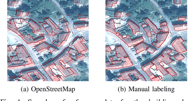
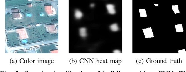
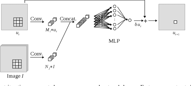
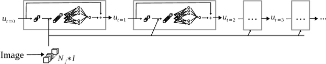
While initially devised for image categorization, convolutional neural networks (CNNs) are being increasingly used for the pixelwise semantic labeling of images. However, the proper nature of the most common CNN architectures makes them good at recognizing but poor at localizing objects precisely. This problem is magnified in the context of aerial and satellite image labeling, where a spatially fine object outlining is of paramount importance. Different iterative enhancement algorithms have been presented in the literature to progressively improve the coarse CNN outputs, seeking to sharpen object boundaries around real image edges. However, one must carefully design, choose and tune such algorithms. Instead, our goal is to directly learn the iterative process itself. For this, we formulate a generic iterative enhancement process inspired from partial differential equations, and observe that it can be expressed as a recurrent neural network (RNN). Consequently, we train such a network from manually labeled data for our enhancement task. In a series of experiments we show that our RNN effectively learns an iterative process that significantly improves the quality of satellite image classification maps.
Progressive Tree-like Curvilinear Structure Reconstruction with Structured Ranking Learning and Graph Algorithm
Dec 08, 2016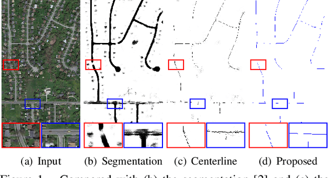
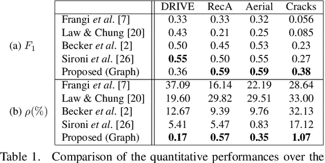
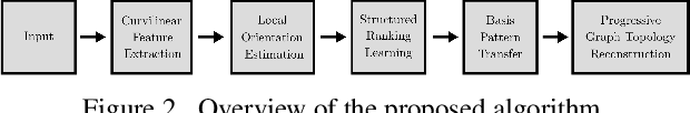
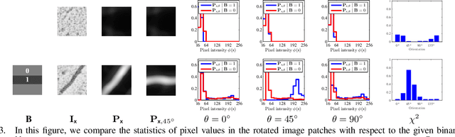
We propose a novel tree-like curvilinear structure reconstruction algorithm based on supervised learning and graph theory. In this work we analyze image patches to obtain the local major orientations and the rankings that correspond to the curvilinear structure. To extract local curvilinear features, we compute oriented gradient information using steerable filters. We then employ Structured Support Vector Machine for ordinal regression of the input image patches, where the ordering is determined by shape similarity to latent curvilinear structure. Finally, we progressively reconstruct the curvilinear structure by looking for geodesic paths connecting remote vertices in the graph built on the structured output rankings. Experimental results show that the proposed algorithm faithfully provides topological features of the curvilinear structures using minimal pixels for various datasets.
High-Resolution Semantic Labeling with Convolutional Neural Networks
Nov 07, 2016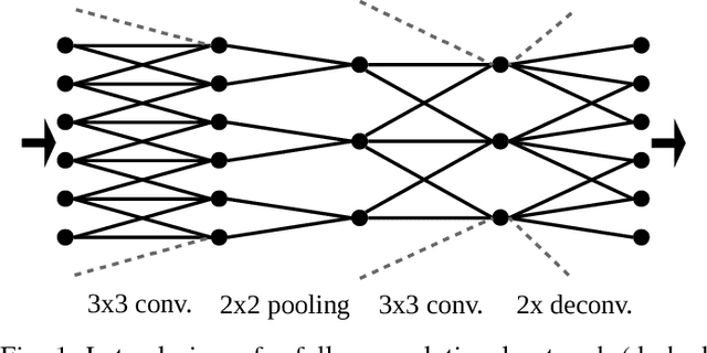
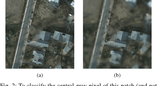
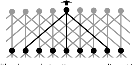
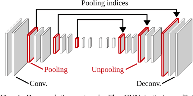
Convolutional neural networks (CNNs) have received increasing attention over the last few years. They were initially conceived for image categorization, i.e., the problem of assigning a semantic label to an entire input image. In this paper we address the problem of dense semantic labeling, which consists in assigning a semantic label to every pixel in an image. Since this requires a high spatial accuracy to determine where labels are assigned, categorization CNNs, intended to be highly robust to local deformations, are not directly applicable. By adapting categorization networks, many semantic labeling CNNs have been recently proposed. Our first contribution is an in-depth analysis of these architectures. We establish the desired properties of an ideal semantic labeling CNN, and assess how those methods stand with regard to these properties. We observe that even though they provide competitive results, these CNNs often underexploit properties of semantic labeling that could lead to more effective and efficient architectures. Out of these observations, we then derive a CNN framework specifically adapted to the semantic labeling problem. In addition to learning features at different resolutions, it learns how to combine these features. By integrating local and global information in an efficient and flexible manner, it outperforms previous techniques. We evaluate the proposed framework and compare it with state-of-the-art architectures on public benchmarks of high-resolution aerial image labeling.