 Add to Chrome
 Add to Firefox
 Add to Edge
Attentive Weakly Supervised land cover mapping for object-based satellite image time series data with spatial interpretation
Apr 30, 2020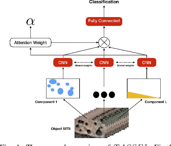


Nowadays, modern Earth Observation systems continuously collect massive amounts of satellite information. The unprecedented possibility to acquire high resolution Satellite Image Time Series (SITS) data (series of images with high revisit time period on the same geographical area) is opening new opportunities to monitor the different aspects of the Earth Surface but, at the same time, it is raising up new challenges in term of suitable methods to analyze and exploit such huge amount of rich and complex image data. One of the main task associated to SITS data analysis is related to land cover mapping where satellite data are exploited via learning methods to recover the Earth Surface status aka the corresponding land cover classes. Due to operational constraints, the collected label information, on which machine learning strategies are trained, is often limited in volume and obtained at coarse granularity carrying out inexact and weak knowledge that can affect the whole process. To cope with such issues, in the context of object-based SITS land cover mapping, we propose a new deep learning framework, named TASSEL (aTtentive weAkly Supervised Satellite image time sEries cLassifier), that is able to intelligently exploit the weak supervision provided by the coarse granularity labels. Furthermore, our framework also produces an additional side-information that supports the model interpretability with the aim to make the black box gray. Such side-information allows to associate spatial interpretation to the model decision via visual inspection.
Fine grained classification for multi-source land cover mapping
Apr 04, 2020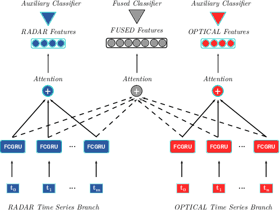
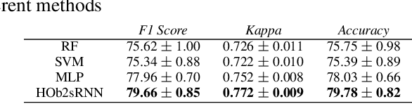
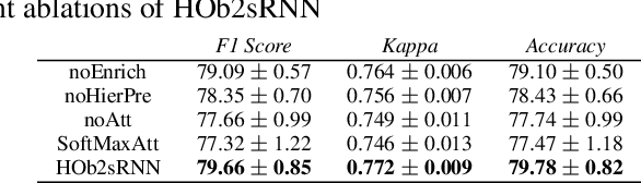
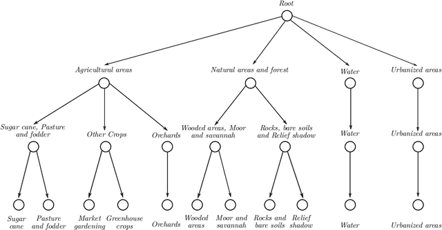
Nowadays, there is a general agreement on the need to better characterize agricultural monitoring systems in response to the global changes. Timely and accurate land use/land cover mapping can support this vision by providing useful information at fine scale. Here, a deep learning approach is proposed to deal with multi-source land cover mapping at object level. The approach is based on an extension of Recurrent Neural Network enriched via an attention mechanism dedicated to multi-temporal data context. Moreover, a new hierarchical pretraining strategy designed to exploit specific domain knowledge available under hierarchical relationships within land cover classes is introduced. Experiments carried out on the Reunion island - a french overseas department - demonstrate the significance of the proposal compared to remote sensing standard approaches for land cover mapping.
Object-based multi-temporal and multi-source land cover mapping leveraging hierarchical class relationships
Nov 20, 2019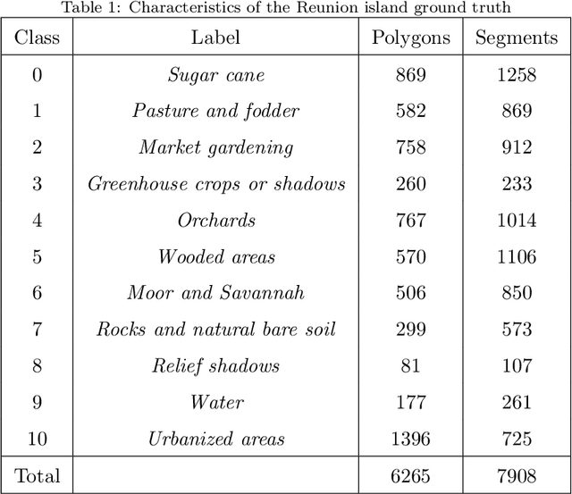
European satellite missions Sentinel-1 (S1) and Sentinel-2 (S2) provide at highspatial resolution and high revisit time, respectively, radar and optical imagesthat support a wide range of Earth surface monitoring tasks such as LandUse/Land Cover mapping. A long-standing challenge in the remote sensingcommunity is about how to efficiently exploit multiple sources of information and leverage their complementary. In this particular case, get the most out ofradar and optical satellite image time series (SITS). Here, we propose to dealwith land cover mapping through a deep learning framework especially tailoredto leverage the multi-source complementarity provided by radar and opticalSITS. The proposed architecture is based on an extension of Recurrent NeuralNetwork (RNN) enriched via a customized attention mechanism capable to fitthe specificity of SITS data. In addition, we propose a new pretraining strategythat exploits domain expert knowledge to guide the model parameter initial-ization. Thorough experimental evaluations involving several machine learningcompetitors, on two contrasted study sites, have demonstrated the suitabilityof our new attention mechanism combined with the extend RNN model as wellas the benefit/limit to inject domain expert knowledge in the neural networktraining process.