 Add to Chrome
 Add to Firefox
 Add to Edge
OmniPath: A Multi-Modal Agentic Framework for Auditing Wheelchair Accessibility
Jun 23, 2026
For a wheelchair user, a standard blue line on a map is often a broken promise. While platforms like OpenStreetMap (OSM) successfully capture where a path is, they frequently fail to convey how it physically feels to travel on it. This information barrier is problematic for wheelchair users. To solve this issue, we present OmniPath, a system that moves from passive mapping to proactive environmental auditing. Our framework fuses the network topology of OSM with the submeter precision of high-density aerial LiDAR (USGS 3DEP) to create a high-fidelity 3D model of the pedestrian environment. Rather than simply routing a user, our agent virtually traverses the network, analyzing the surface in 0.5 meter increments. It rigorously quantifies physical friction points specifically running slope, cross slope, and vertical discontinuities against ADA compliance standards, calculating a weighted severity score to categorize hazards from ``Mild'' to ``Critical.'' To ensure real world reliability, we validated the system against 200 physical ground truth field surveys across the National Mall using stratified random sampling. The framework demonstrated strong diagnostic reliability for high-severity hazards, achieving F1-scores of 0.60 for Severe and 0.58 for critical categories. By automating this micro-scale inspection, OmniPath identifies the ``invisible'' barriers that standard maps miss, effectively transforming a static dataset into accessibility data source that anticipates accessibility challenges before the user ever leaves home.

OmniAcc: Personalized Accessibility Assistant Using Generative AI
Sep 08, 2025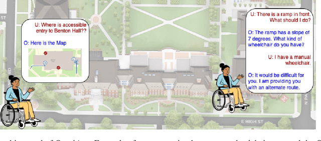
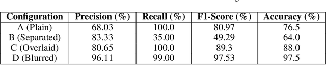
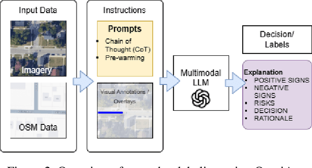
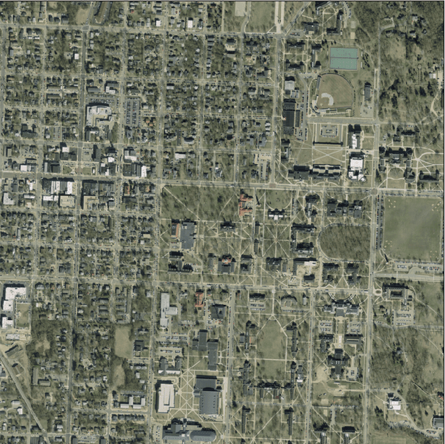
Individuals with ambulatory disabilities often encounter significant barriers when navigating urban environments due to the lack of accessible information and tools. This paper presents OmniAcc, an AI-powered interactive navigation system that utilizes GPT-4, satellite imagery, and OpenStreetMap data to identify, classify, and map wheelchair-accessible features such as ramps and crosswalks in the built environment. OmniAcc offers personalized route planning, real-time hands-free navigation, and instant query responses regarding physical accessibility. By using zero-shot learning and customized prompts, the system ensures precise detection of accessibility features, while supporting validation through structured workflows. This paper introduces OmniAcc and explores its potential to assist urban planners and mobility-aid users, demonstrated through a case study on crosswalk detection. With a crosswalk detection accuracy of 97.5%, OmniAcc highlights the transformative potential of AI in improving navigation and fostering more inclusive urban spaces.
DeliverAI: Reinforcement Learning Based Distributed Path-Sharing Network for Food Deliveries
Nov 03, 2023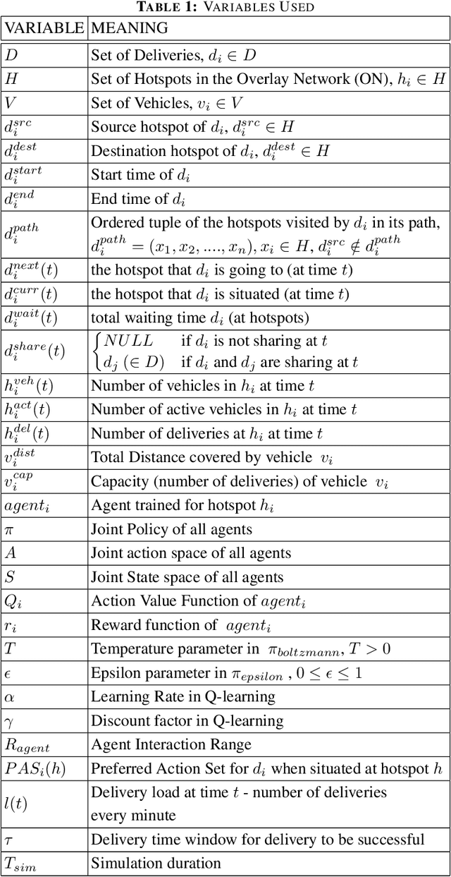
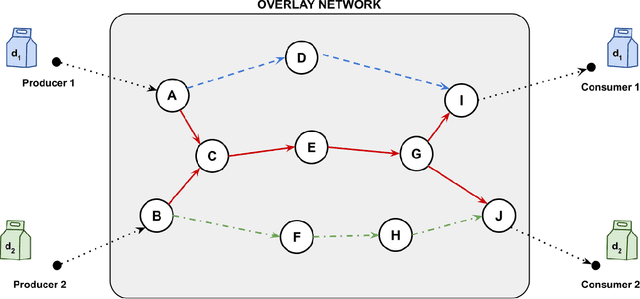
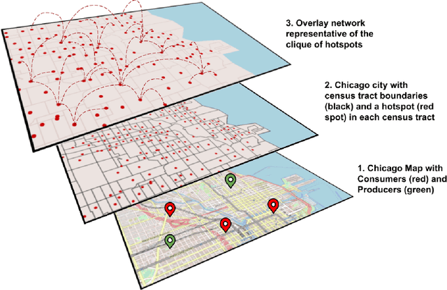

Delivery of items from the producer to the consumer has experienced significant growth over the past decade and has been greatly fueled by the recent pandemic. Amazon Fresh, Shopify, UberEats, InstaCart, and DoorDash are rapidly growing and are sharing the same business model of consumer items or food delivery. Existing food delivery methods are sub-optimal because each delivery is individually optimized to go directly from the producer to the consumer via the shortest time path. We observe a significant scope for reducing the costs associated with completing deliveries under the current model. We model our food delivery problem as a multi-objective optimization, where consumer satisfaction and delivery costs, both, need to be optimized. Taking inspiration from the success of ride-sharing in the taxi industry, we propose DeliverAI - a reinforcement learning-based path-sharing algorithm. Unlike previous attempts for path-sharing, DeliverAI can provide real-time, time-efficient decision-making using a Reinforcement learning-enabled agent system. Our novel agent interaction scheme leverages path-sharing among deliveries to reduce the total distance traveled while keeping the delivery completion time under check. We generate and test our methodology vigorously on a simulation setup using real data from the city of Chicago. Our results show that DeliverAI can reduce the delivery fleet size by 12\%, the distance traveled by 13%, and achieve 50% higher fleet utilization compared to the baselines.