 Add to Chrome
 Add to Firefox
 Add to Edge
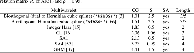
Bauer's Spectral Factorization Method for Low Order Multiwavelet Filter Design
Dec 09, 2023


Para-Hermitian polynomial matrices obtained by matrix spectral factorization lead to functions useful in control theory systems, basis functions in numerical methods or multiscaling functions used in signal processing. We introduce a fast algorithm for matrix spectral factorization based on Bauer$'$s method. We convert Bauer$'$ method into a nonlinear matrix equation (NME). The NME is solved by two different numerical algorithms (Fixed Point Iteration and Newton$'$s Method) which produce approximate scalar or matrix factors, as well as a symbolic algorithm which produces exact factors in closed form for some low-order scalar or matrix polynomial matrices, respectively. Convergence rates of the two numerical algorithms are investigated for a number of singular and nonsingular scalar and matrix polynomials taken from different areas. In particular, one of the singular examples leads to new orthogonal multiscaling and multiwavelet filters. Since the NME can also be solved as a Generalized Discrete Time Algebraic Riccati Equation (GDARE), numerical results using built-in routines in Maple 17.0 and 6 Matlab versions are presented.
* 24 pages,5 figures, 4 tables,
Assessing of Soil Erosion Risk Through Geoinformation Sciences and Remote Sensing -- A Review
Oct 12, 2023During past decades a marked manifestation of widespread erosion phenomena was studied worldwide. Global conservation community has launched campaigns at local, regional and continental level in developing countries for preservation of soil resources in order not only to stop or mitigate human impact on nature but also to improve life in rural areas introducing new approaches for soil cultivation. After the adoption of Sustainable Development Goals of UNs and launching several world initiatives such as the Land Degradation Neutrality (LDN) the world came to realize the very importance of the soil resources on which the biosphere relies for its existence. The main goal of the chapter is to review different types and structures erosion models as well as their applications. Several methods using spatial analysis capabilities of geographic information systems (GIS) are in operation for soil erosion risk assessment, such as Universal Soil Loss Equation (USLE), Revised Universal Soil Loss Equation (RUSLE) in operation worldwide and in the USA and MESALES model. These and more models are being discussed in the present work alongside more experimental models and methods for assessing soil erosion risk such as Artificial Intelligence (AI), Machine and Deep Learning, etc. At the end of this work, a prospectus for the future development of soil erosion risk assessment is drawn.
* Chapter 21 (pages 54)
Wavelet Coherence Of Total Solar Irradiance and Atlantic Climate
May 03, 2023
The oscillations of climatic parameters of North Atlantic Ocean play important role in various events in North America and Europe. Several climatic indices are associated with these oscillations. The long term Atlantic temperature anomalies are described by the Atlantic Multidecadal Oscillation (AMO). The Atlantic Multidecadal Oscillation also known as Atlantic Multidecadal Variability (AMV), is the variability of the sea surface temperature (SST) of the North Atlantic Ocean at the timescale of several decades. The AMO is correlated to air temperatures and rainfall over much of the Northern Hemisphere, in particular in the summer climate in North America and Europe. The long-term variations of surface temperature are driven mainly by the cycles of solar activity, represented by the variations of the Total Solar Irradiance (TSI). The frequency and amplitude dependences between the TSI and AMO are analyzed by wavelet coherence of millennial time series since 800 AD till now. The results of wavelet coherence are compared with the detected common solar and climate cycles in narrow frequency bands by the method of Partial Fourier Approximation. The long-term coherence between TSI and AMO can help to understand better the recent climate change and can improve the long term forecast.
* pages 12, Proceedings of the XIII Bulgarian-Serbian Astronomical Conference (XIII BSAC), Velingrad, Bulgaria, 2022
Big Data in Astroinformatics -- Compression of Scanned Astronomical Photographic Plates
Aug 24, 2021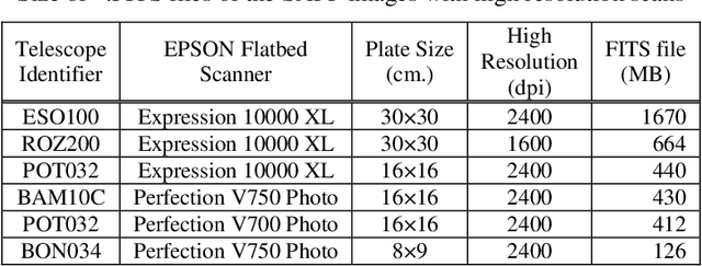
Construction of Scanned Astronomical Photographic Plates(SAPPs) databases and SVD image compression algorithm are considered. Some examples of compression with different plates are shown.
Challenges and Solutions for Utilizing Earth Observations in the "Big Data" era
Aug 19, 2021The ever-growing need of data preservation and their systematic analysis contributing to sustainable development of the society spurred in the past decade,numerous Big Data projects and initiatives are focusing on the Earth Observation (EO). The number of Big Data EO applications has grown extremely worldwide almost simultaneously with other scientific and technological areas of the human knowledge due to the revolutionary technological progress in the space and information technology sciences. The substantial contribution to this development are the space programs of the renowned space agencies, such as NASA, ESA,Roskosmos, JAXA, DLR, INPE, ISRO, CNES etc. A snap-shot of the current Big Data sets from available satellite missions covering the Bulgarian territory is also presented. This short overview of the geoscience Big Data collection with a focus on EO will emphasize to the multiple Vs of EO in order to provide a snapshot on the current state-of-the-art in EO data preservation and manipulation. Main modern approaches for compressing, clustering and modelling EO in the geoinformation science for Big Data analysis, interpretation and visualization for a variety of applications are outlined. Special attention is paid to the contemporary EO data modelling and visualization systems.
Design of a Simple Orthogonal Multiwavelet Filter by Matrix Spectral Factorization
Oct 16, 2019
We consider the design of an orthogonal symmetric/antisymmetric multiwavelet from its matrix product filter by matrix spectral factorization (MSF). As a test problem, we construct a simple matrix product filter with desirable properties, and factor it using Bauer's method, which in this case can be done in closed form. The corresponding orthogonal multiwavelet function is derived using algebraic techniques which allow symmetry to be considered. This leads to the known orthogonal multiwavelet SA1, which can also be derived directly. We also give a lifting scheme for SA1, investigate the influence of the number of significant digits in the calculations, and show some numerical experiments.
Singular Value Decomposition of Images from Scanned Photographic Plates
Oct 07, 2013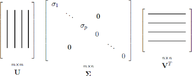
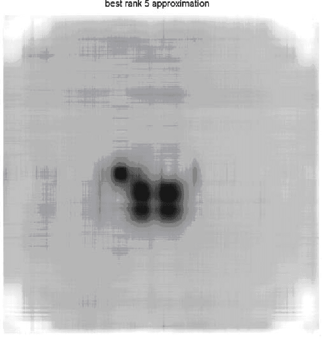
We want to approximate the mxn image A from scanned astronomical photographic plates (from the Sofia Sky Archive Data Center) by using far fewer entries than in the original matrix. By using rank of a matrix, k we remove the redundant information or noise and use as Wiener filter, when rank k<m or k<n. With this approximation more than 98% compression ration of image of astronomical plate without that image details, is obtained. The SVD of images from scanned photographic plates (SPP) is considered and its possible image compression.
* pages 15, Proceedings of the VII Bulgarian-Serbian Astronomical Conference,Bulgaria,2010
Compressed sensing of astronomical images: orthogonal wavelets domains
Nov 29, 2011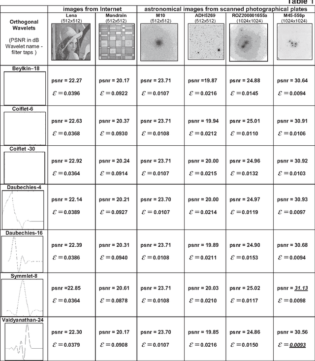
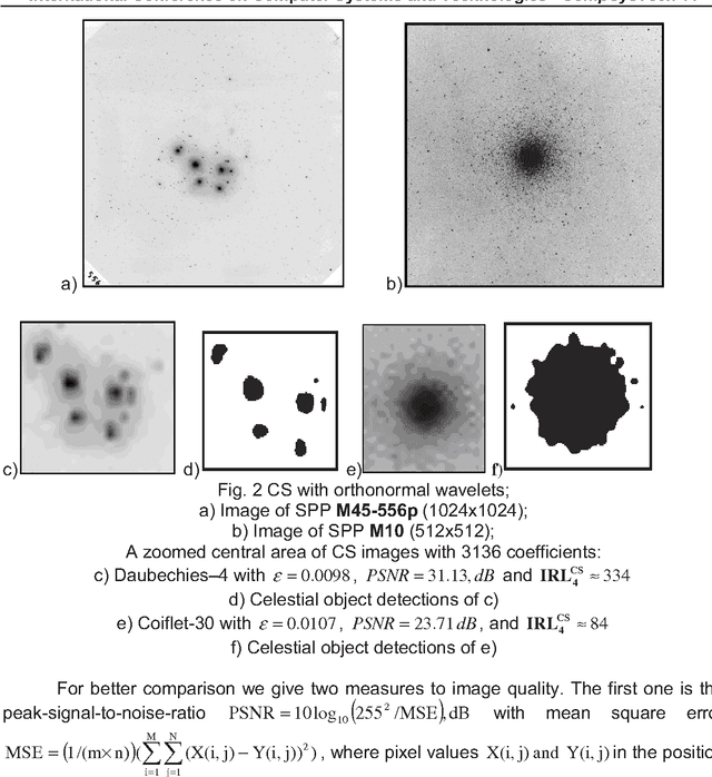
A simple approach for orthogonal wavelets in compressed sensing (CS) applications is presented. We compare efficient algorithm for different orthogonal wavelet measurement matrices in CS for image processing from scanned photographic plates (SPP). Some important characteristics were obtained for astronomical image processing of SPP. The best orthogonal wavelet choice for measurement matrix construction in CS for image compression of images of SPP is given. The image quality measure for linear and nonlinear image compression method is defined.
Multiplierless Modules for Forward and Backward Integer Wavelet Transform
Jun 24, 2011


This article is about the architecture of a lossless wavelet filter bank with reprogrammable logic. It is based on second generation of wavelets with a reduced of number of operations. A new basic structure for parallel architecture and modules to forward and backward integer discrete wavelet transform is proposed.
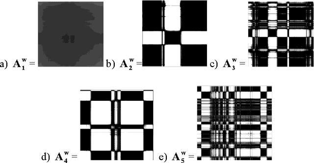
Orthogonal multifilters image processing of astronomical images from scanned photographic plates
Oct 16, 2010In this paper orthogonal multifilters for astronomical image processing are presented. We obtained new orthogonal multifilters based on the orthogonal wavelet of Haar and Daubechies. Recently, multiwavelets have been introduced as a more powerful multiscale analysis tool. It adds several degrees of freedom in multifilter design and makes it possible to have several useful properties such as symmetry, orthogonality, short support, and a higher number of vanishing moments simultaneously. Multifilter decomposition of scanned photographic plates with astronomical images is made.