 Add to Chrome
 Add to Firefox
 Add to Edge
Feasibility to detect rapid change and disappearance of seagrass: Lessons from nearly 80 years of vegetation change in the Ako, Seto Inland Sea, Japan
Jun 06, 2026This study analyses the Ako tidal flat in the Seto Inland Sea, Japan, where nearly all Zostera marina disappeared within a single year in 2025. Using aerial photographs from the 1940s onward, high-resolution satellite imagery, GRUS images (2.5-5 m), and monthly Sentinel-2 composites (10 m), we reconstructed approximately 80 years of seagrass distribution. YOLO-based segmentation using deep learning achieved high accuracy (overall accuracy >= 0.9) across these datasets; although species could not be discriminated, the models captured the major temporal dynamics in vegetation area. The long-term mean seagrass area was 6.8 ha, but values fluctuated widely, from 3.5 ha in 1974 to 41.3 ha in 1989 except 0.2 ha in 2025. Sentinel-2 composites from 2019 to 2026 revealed clear seasonality, with vegetation increasing in early summer and declining from autumn. In 2025, however, the area decreased sharply after summer and remained anomalously low throughout the winter of 2025-2026. Our results, indicating that the 2025 event was not a normal fluctuation but a rapid ecosystem shift involving the loss of the dominant canopy-forming species, most plausibly driven by regionally elevated summer water temperatures. The findings also have implications for seagrass Essential Ocean Variables (EOVs) and the State of Nature (SoN) metrics used in TNFD-aligned nature-related disclosures. Unlike forests, seagrass meadows require finer temporal resolution because both pronounced seasonality and abrupt collapse strongly influence area-based indicators. Therefore, in addition to previously noted issues such as species-level classification accuracy, we recommend that (1) baselines be defined over the longest available record and justified ecologically, (2) seasonal standardization be applied before inter-annual comparisons, and (3) years with extreme area anomalies be flagged rather than used as reference points.
Eelgrass beds and oyster farming at a lagoon before and after the Great East Japan Earthquake 2011: potential to apply deep learning at a coastal area
Sep 06, 2019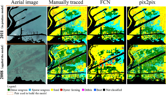
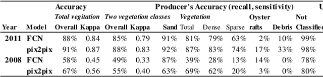
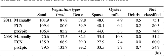
There is a small number of case studies of automatic land cover classification on the coastal area. Here, I test extraction of seagrass beds, sandy area, oyster farming rafts at Mangoku-ura Lagoon, Miyagi, Japan by comparing manual tracing, simple image segmentation, and image transformation using deep learning. The result was used to extract the changes before and after the earthquake and tsunami. The output resolution was best in the image transformation method, which showed more than 69% accuracy for vegetation classification by an assessment using random points on independent test data. The distribution of oyster farming rafts was detected by the segmentation model. Assessment of the change before and after the earthquake by the manual tracing and image transformation result revealed increase of sand area and decrease of the vegetation. By the segmentation model only the decrease of the oyster farming was detected. These results demonstrate the potential to extract the spatial pattern of these elements after an earthquake and tsunami. Index Terms: Great East Japan Earthquake of 2011, Land use land cover (LULC), Zosteracea seagrass, cultured oyster, deep learning, Mangoku Bay