 Add to Chrome
 Add to Firefox
 Add to Edge
Semantic-Driven Scale and Spatial Selection for Efficient Cross-Modal Alignment in Referring Remote Sensing Image Segmentation
Jun 29, 2026Referring Remote Sensing Image Segmentation (RRSIS) seeks to localize and segment the target object or region specified by a natural language expression in a remote sensing image. While existing RRSIS models have benefited from large-scale foundation models, they predominantly rely on full fine-tuning. These approaches are computationally intensive and may weaken the generalization ability of pre-trained models, as extensive fine-tuning on significantly smaller downstream datasets can distort the well-structured feature representations learned during large-scale pre-training. Although Parameter-Efficient Tuning (PET) offers a potential alternative, existing PET frameworks primarily focus on single-modal optimization, failing to capture the complex cross-modal dependencies required for multimodal reasoning, while simultaneously struggling to bridge the substantial domain gap between natural scenes and aerial imagery. To address these limitations, we propose a novel framework, Semantic-driven Scale and Spatial Selection for Efficient Cross-modal Alignment (S4ECA), which enables effective and efficient cross-modal interaction through parameter-efficient adaptation. Specifically, we design a dual-encoder adapter architecture. The textual adapter employs learnable queries to distill highly semantic language proxies from word-level embeddings, facilitating early grounding. Simultaneously, the visual adapter refines hierarchical feature representations through a multi-scale dense extractor, followed by a language-guided scale and spatial selection mechanism that dynamically emphasizes relevant visual contexts, ensuring precise cross-modal alignment. By updating only 2.4% of the backbone parameters, our proposed model achieves state-of-the-art performance on the RRSIS-D and RefSegRS datasets, demonstrating superior efficiency and precision in complex aerial scenarios.
Advancing Applications of Satellite Photogrammetry: Novel Approaches for Built-up Area Modeling and Natural Environment Monitoring using Stereo/Multi-view Satellite Image-derived 3D Data
Apr 18, 2024


With the development of remote sensing technology in recent decades, spaceborne sensors with sub-meter and meter spatial resolution (Worldview and PlanetScope) have achieved a considerable image quality to generate 3D geospatial data via a stereo matching pipeline. These achievements have significantly increased the data accessibility in 3D, necessitating adapting these 3D geospatial data to analyze human and natural environments. This dissertation explores several novel approaches based on stereo and multi-view satellite image-derived 3D geospatial data, to deal with remote sensing application issues for built-up area modeling and natural environment monitoring, including building model 3D reconstruction, glacier dynamics tracking, and lake algae monitoring. Specifically, the dissertation introduces four parts of novel approaches that deal with the spatial and temporal challenges with satellite-derived 3D data. The first study advances LoD-2 building modeling from satellite-derived Orthophoto and DSMs with a novel approach employing a model-driven workflow that generates building rectangular 3D geometry models. Secondly, we further enhanced our building reconstruction framework for dense urban areas and non-rectangular purposes, we implemented deep learning for unit-level segmentation and introduced a gradient-based circle reconstruction for circular buildings to develop a polygon composition technique for advanced building LoD2 reconstruction. Our third study utilizes high-spatiotemporal resolution PlanetScope satellite imagery for glacier tracking at 3D level in mid-latitude regions. Finally, we proposed a term as "Algal Behavior Function" to refine the quantification of chlorophyll-a concentrations from satellite imagery in water quality monitoring, addressing algae fluctuations and timing discrepancies between satellite observations and field measurements, thus enhancing the precision of underwater algae volume estimates. Overall, this dissertation demonstrates the extensive potential of satellite photogrammetry applications in addressing urban and environmental challenges. It further showcases innovative analytical methodologies that enhance the applicability of adapting stereo and multi-view very high-resolution satellite-derived 3D data. (See full abstract in the document)
Sat2lod2: A Software For Automated Lod-2 Modeling From Satellite-Derived Orthophoto And Digital Surface Model
Apr 08, 2022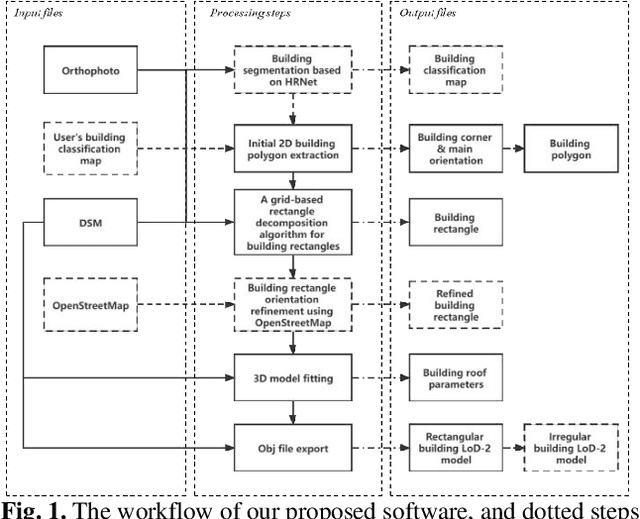
Deriving LoD2 models from orthophoto and digital surface models (DSM) reconstructed from satellite images is a challenging task. Existing solutions are mostly system approaches that require complicated step-wise processes, including not only heuristic geometric operations, but also high-level steps such as machine learning-based semantic segmentation and building detection. Here in this paper, we describe an open-source tool, called SAT2LOD2, built based on a minorly modified version of our recently published work. SAT2LoD2 is a fully open-source and GUI (Graphics User Interface) based software, coded in Python, which takes an orthophoto and DSM as inputs, and outputs individual building models, and it can additionally take road network shapefiles, and customized classification maps to further improve the reconstruction results. We further improve the robustness of the method by 1) intergrading building segmentation based on HRNetV2 into our software; and 2) having implemented a decision strategy to identify complex buildings and directly generate mesh to avoid erroneous LoD2 reconstruction from a system point of view. The software can process a moderate level of data (around 5000*5000 size of orthophoto and DSM) using a PC with a graphics card supporting CUDA. Furthermore, the GUI is self-contained and stores the intermediate processing results facilitating researchers to learn the process easily and reuse intermediate files as needed. The updated codes and software are available under this GitHub page: https://github.com/GDAOSU/LOD2BuildingModel.
Automated LoD-2 Model Reconstruction from Very-HighResolution Satellite-derived Digital Surface Model and Orthophoto
Sep 08, 2021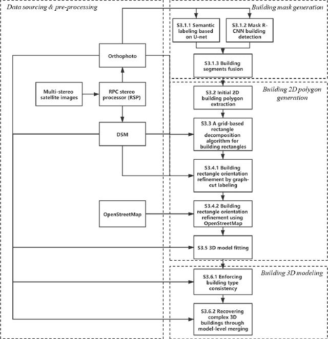

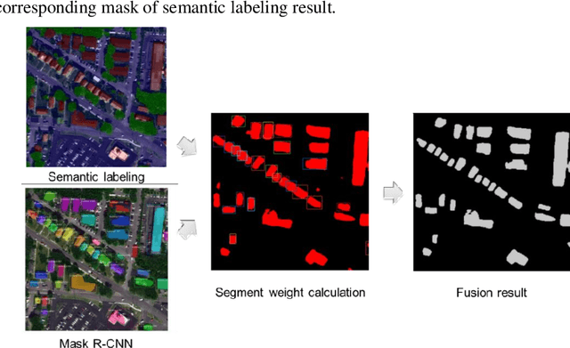

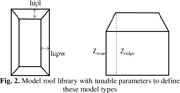
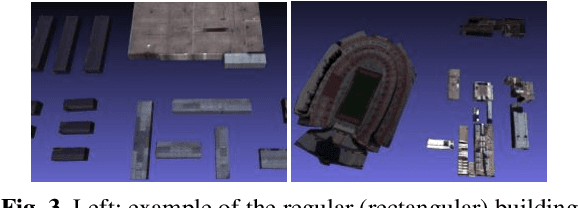
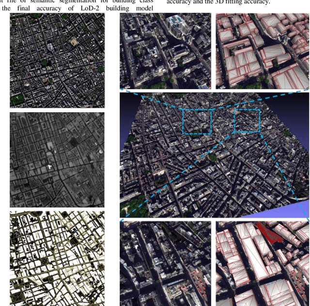
In this paper, we propose a model-driven method that reconstructs LoD-2 building models following a "decomposition-optimization-fitting" paradigm. The proposed method starts building detection results through a deep learning-based detector and vectorizes individual segments into polygons using a "three-step" polygon extraction method, followed by a novel grid-based decomposition method that decomposes the complex and irregularly shaped building polygons to tightly combined elementary building rectangles ready to fit elementary building models. We have optionally introduced OpenStreetMap (OSM) and Graph-Cut (GC) labeling to further refine the orientation of 2D building rectangle. The 3D modeling step takes building-specific parameters such as hip lines, as well as non-rigid and regularized transformations to optimize the flexibility for using a minimal set of elementary models. Finally, roof type of building models s refined and adjacent building models in one building segment are merged into the complex polygonal model. Our proposed method has addressed a few technical caveats over existing methods, resulting in practically high-quality results, based on our evaluation and comparative study on a diverse set of experimental datasets of cities with different urban patterns.