 Add to Chrome
 Add to Firefox
 Add to Edge
Towards Democratized Flood Risk Management: An Advanced AI Assistant Enabled by GPT-4 for Enhanced Interpretability and Public Engagement
Mar 05, 2024Real-time flood forecasting plays a crucial role in enabling timely and effective emergency responses. However, a significant challenge lies in bridging the gap between complex numerical flood models and practical decision-making. Decision-makers often rely on experts to interpret these models for optimizing flood mitigation strategies. And the public requires complex techniques to inquiry and understand socio-cultural and institutional factors, often hinders the public's understanding of flood risks. To overcome these challenges, our study introduces an innovative solution: a customized AI Assistant powered by the GPT-4 Large Language Model. This AI Assistant is designed to facilitate effective communication between decision-makers, the general public, and flood forecasters, without the requirement of specialized knowledge. The new framework utilizes GPT-4's advanced natural language understanding and function calling capabilities to provide immediate flood alerts and respond to various flood-related inquiries. Our developed prototype integrates real-time flood warnings with flood maps and social vulnerability data. It also effectively translates complex flood zone information into actionable risk management advice. To assess its performance, we evaluated the prototype using six criteria within three main categories: relevance, error resilience, and understanding of context. Our research marks a significant step towards a more accessible and user-friendly approach in flood risk management. This study highlights the potential of advanced AI tools like GPT-4 in democratizing information and enhancing public engagement in critical social and environmental issues.
Semi-supervised Identification and Mapping of Surface Water Extent using Street-level Monitoring Videos
Jan 31, 2022Urban flooding is becoming a common and devastating hazard to cause life loss and economic damage. Monitoring and understanding urban flooding in the local scale is a challenging task due to the complicated urban landscape, intricate hydraulic process, and the lack of high-quality and resolution data. The emerging smart city technology such as monitoring cameras provides an unprecedented opportunity to address the data issue. However, estimating the water accumulation on the land surface based on the monitoring footage is unreliable using the traditional segmentation technique because the boundary of the water accumulation, under the influence of varying weather, background, and illumination, is usually too fuzzy to identify, and the oblique angle and image distortion in the video monitoring data prevents georeferencing and object-based measurements. This paper presents a novel semi-supervised segmentation scheme for surface water extent recognition from the footage of an oblique monitoring camera. The semi-supervised segmentation algorithm was found suitable to determine the water boundary and the monoplotting method was successfully applied to georeference the pixels of the monitoring video for the virtual quantification of the local drainage process. The correlation and mechanism-based analysis demonstrates the value of the proposed method in advancing the understanding of local drainage hydraulics. The workflow and created methods in this study has a great potential to study other street-level and earth surface processes.
A Recommender System-Inspired Cloud Data Filling Scheme for Satellite-based Coastal Observation
Dec 10, 2021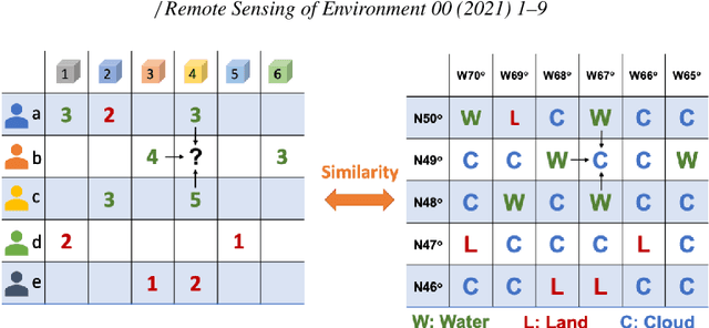
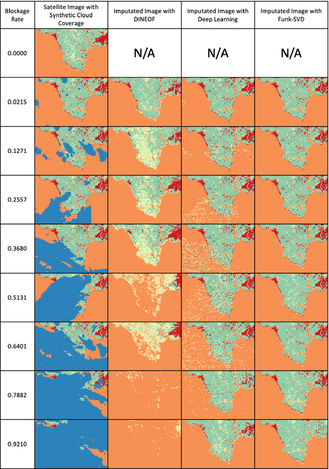
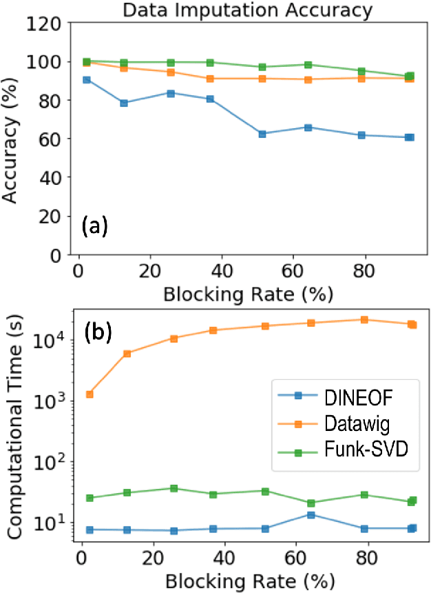
Filling missing data in cloud-covered areas of satellite imaging is an important task to improve data quantity and quality for enhanced earth observation. Traditional cloud filling studies focused on continuous numerical data such as temperature and cyanobacterial concentration in the open ocean. Cloud data filling issues in coastal imaging is far less studied because of the complex landscape. Inspired by the success of data imputation methods in recommender systems that are designed for online shopping, the present study explored their application to satellite cloud data filling tasks. A numerical experiment was designed and conducted for a LandSat dataset with a range of synthetic cloud covers to examine the performance of different data filling schemes. The recommender system-inspired matrix factorization algorithm called Funk-SVD showed superior performance in computational accuracy and efficiency for the task of recovering landscape types in a complex coastal area than the traditional data filling scheme of DINEOF (Data Interpolating Empirical Orthogonal Functions) and the deep learning method of Datawig. The new method achieved the best filling accuracy and reached a speed comparable to DINEOF and much faster than deep learning. A theoretical framework was created to analyze the error propagation in DINEOF and found the algorithm needs to be modified to converge to the ground truth. The present study showed that Funk-SVD has great potential to enhance cloud data filling performance and connects the fields of recommender systems and cloud filling to promote the improvement and sharing of useful algorithms.
AI-supported Framework of Semi-Automatic Monoplotting for Monocular Oblique Visual Data Analysis
Nov 28, 2021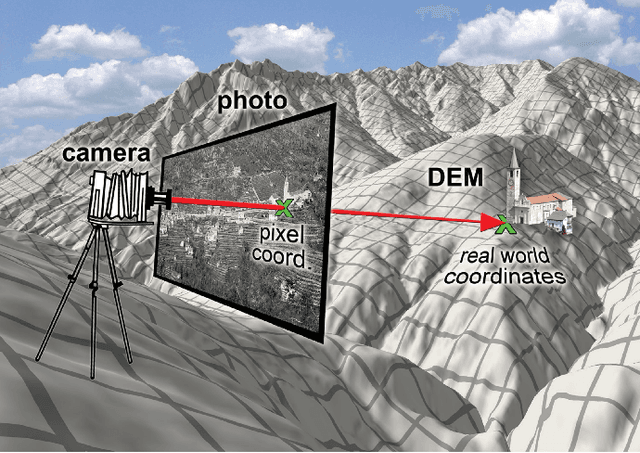
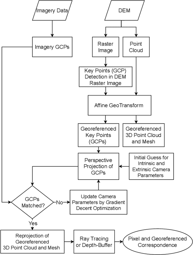
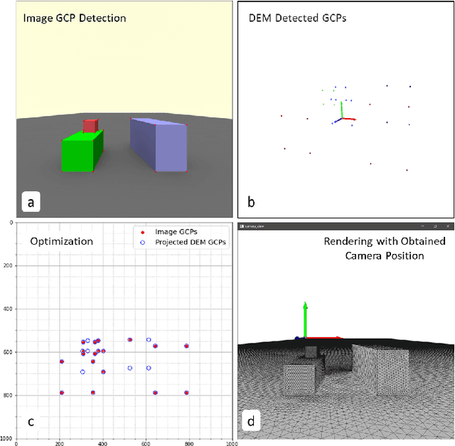
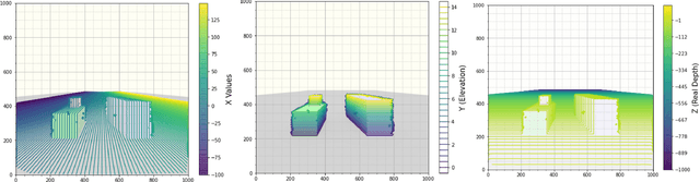
In the last decades, the development of smartphones, drones, aerial patrols, and digital cameras enabled high-quality photographs available to large populations and, thus, provides an opportunity to collect massive data of the nature and society with global coverage. However, the data collected with new photography tools is usually oblique - they are difficult to be georeferenced, and huge amounts of data is often obsolete. Georeferencing oblique imagery data may be solved by a technique called monoplotting, which only requires a single image and Digital Elevation Model (DEM). In traditional monoplotting, a human user has to manually choose a series of ground control point (GCP) pairs in the image and DEM and then determine the extrinsic and intrinsic parameters of the camera to establish a pixel-level correspondence between photos and the DEM to enable the mapping and georeferencing of objects in photos. This traditional method is difficult to scale due to several challenges including the labor-intensive inputs, the need of rich experience to identify well-defined GCPs, and limitations in camera pose estimation. Therefore, existing monoplotting methods are rarely used in analyzing large-scale databases or near-real-time warning systems. In this paper, we propose and demonstrate a novel semi-automatic monoplotting framework that provides pixel-level correspondence between photos and DEMs requiring minimal human interventions. A pipeline of analyses was developed including key point detection in images and DEM rasters, retrieving georeferenced 3D DEM GCPs, regularized gradient-based optimization, pose estimation, ray tracing, and the correspondence identification between image pixels and real world coordinates. Two numerical experiments show that the framework is superior in georeferencing visual data in 3-D coordinates, paving a way toward fully automatic monoplotting methodology.