 Add to Chrome
 Add to Firefox
 Add to Edge
Open Access Battle Damage Detection via Pixel-Wise T-Test on Sentinel-1 Imagery
May 10, 2024


In the context of recent, highly destructive conflicts in Gaza and Ukraine, reliable estimates of building damage are essential for an informed public discourse, human rights monitoring, and humanitarian aid provision. Given the contentious nature of conflict damage assessment, these estimates must be fully reproducible, explainable, and derived from open access data. This paper introduces a new method for building damage detection-- the Pixel-Wise T-Test (PWTT)-- that satisfies these conditions. Using a combination of freely-available synthetic aperture radar imagery and statistical change detection, the PWTT generates accurate conflict damage estimates across a wide area at regular time intervals. Accuracy is assessed using an original dataset of over half a million labeled building footprints spanning 12 cities across Ukraine, Palestine, Syria, and Iraq. Despite being simple and lightweight, the algorithm achieves building-level accuracy statistics (AUC=0.88 across Ukraine, 0.81 in Gaza) rivalling state of the art methods that use deep learning and high resolution imagery. The workflow is open source and deployed entirely within the Google Earth Engine environment, allowing for the generation of interactive Battle Damage Dashboards for Ukraine and Gaza that update in near-real time, allowing the public and humanitarian practitioners to immediately get estimates of damaged buildings in a given area.
Automatic Detection of Dark Ship-to-Ship Transfers using Deep Learning and Satellite Imagery
Apr 11, 2024Despite extensive research into ship detection via remote sensing, no studies identify ship-to-ship transfers in satellite imagery. Given the importance of transshipment in illicit shipping practices, this is a significant gap. In what follows, I train a convolutional neural network to accurately detect 4 different types of cargo vessel and two different types of Ship-to-Ship transfer in PlanetScope satellite imagery. I then elaborate a pipeline for the automatic detection of suspected illicit ship-to-ship transfers by cross-referencing satellite detections with vessel borne GPS data. Finally, I apply this method to the Kerch Strait between Ukraine and Russia to identify over 400 dark transshipment events since 2022.
Insurgency as Complex Network: Image Co-Appearance and Hierarchy in the PKK
Jul 14, 2022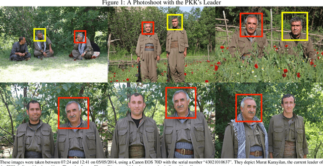
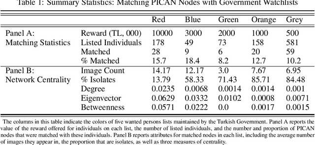
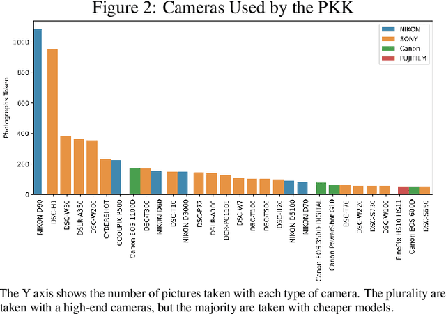
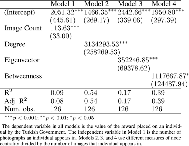
Despite a growing recognition of the importance of insurgent group structure on conflict outcomes, there is very little empirical research thereon. Though this problem is rooted in the inaccessibility of data on militant group structure, insurgents frequently publish large volumes of image data on the internet. In this paper, I develop a new methodology that leverages this abundant but underutilized source of data by automating the creation of a social network graph based on co-appearance in photographs using deep learning. Using a trove of 19,115 obituary images published online by the PKK, a Kurdish militant group in Turkey, I demonstrate that an individual's centrality in the resulting co-appearance network is closely correlated with their rank in the insurgent group.