 Add to Chrome
 Add to Firefox
 Add to Edge
Airplane Detection Based on Mask Region Convolution Neural Network
Aug 29, 2021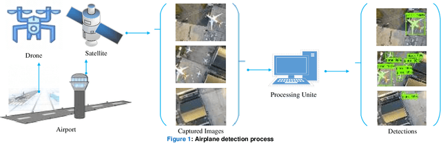
Addressing airport traffic jams is one of the most crucial and challenging tasks in the remote sensing field, especially for the busiest airports. Several solutions have been employed to address this problem depending on the airplane detection process. The most effective solutions are through the use of satellite images with deep learning techniques. Such solutions, however, are significantly costly and require satellites and modern complicated technology which may not be available in most countries worldwide. This paper provides a universal, low cost and fast solution for airplane detection in airports. This paper recommends the use of drones instead of satellites to feed the system with drone images using a proposed deep learning model. Drone images are employed as the dataset to train and evaluate a mask region convolution neural network (RCNN) model. The Mask RCNN model applies faster RCNN as its base configuration with critical modifications on its head neural network constructions. The model detects whether or not an airplane is present and includes mask estimations to approximate surface area and length, which will help future works identify the airplane type. This solution can be easily implemented globally as it is a low-cost and fast solution for airplane detection at airports. The evaluation process reveals promising results according to Microsoft Common Objects in Context (COCO) metrics.
Airplane Type Identification Based on Mask RCNN and Drone Images
Aug 29, 2021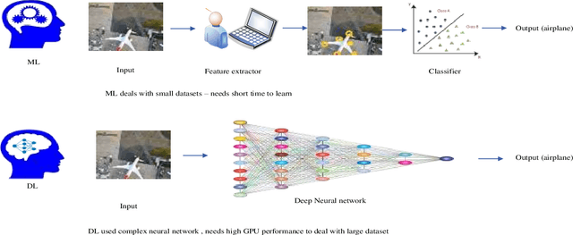
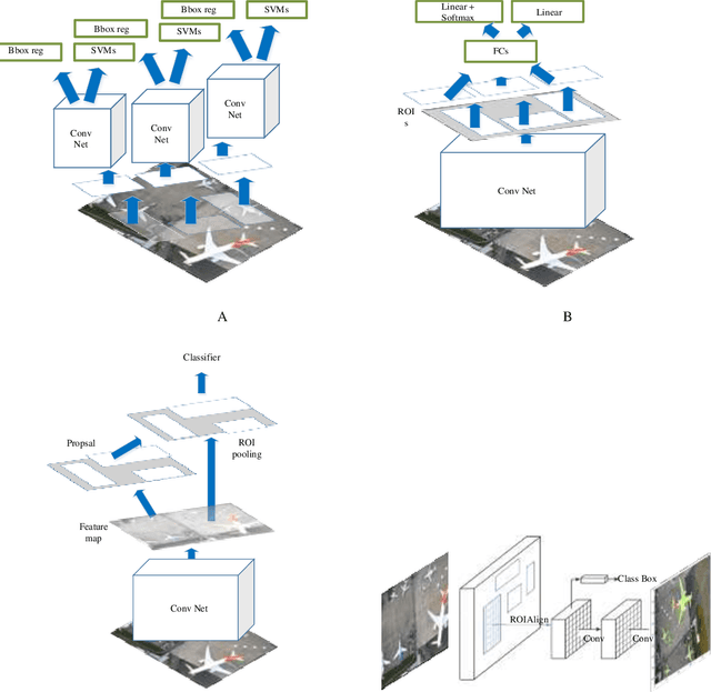
For dealing with traffic bottlenecks at airports, aircraft object detection is insufficient. Every airport generally has a variety of planes with various physical and technological requirements as well as diverse service requirements. Detecting the presence of new planes will not address all traffic congestion issues. Identifying the type of airplane, on the other hand, will entirely fix the problem because it will offer important information about the plane's technical specifications (i.e., the time it needs to be served and its appropriate place in the airport). Several studies have provided various contributions to address airport traffic jams; however, their ultimate goal was to determine the existence of airplane objects. This paper provides a practical approach to identify the type of airplane in airports depending on the results provided by the airplane detection process using mask region convolution neural network. The key feature employed to identify the type of airplane is the surface area calculated based on the results of airplane detection. The surface area is used to assess the estimated cabin length which is considered as an additional key feature for identifying the airplane type. The length of any detected plane may be calculated by measuring the distance between the detected plane's two furthest points. The suggested approach's performance is assessed using average accuracies and a confusion matrix. The findings show that this method is dependable. This method will greatly aid in the management of airport traffic congestion.
Airplane Type Identification Based on Mask RCNN; An Approach to Reduce Airport Traffic Congestion
Aug 25, 2021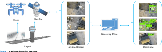
One of the most difficult jobs in remote sensing is dealing with traffic bottlenecks at airports. This fact has been confirmed by several studies attempting to resolve this issue. Among a wide range of approaches employed the most successful methods have been based on airplane object recognition using satellite images as datasets for deep learning models. Airplane object identification is not a viable method for resolving traffic congestion. There are several types of airplanes at the airport each with its own set of requirements and specifications.Utilizing satellite pictures will require the use of complex equipment which is a financial burden. In this work a universal low-cost and efficient solution for airport traffic congestion is proposed. Drone-captured aerial pictures are used to train and assess a Mask Region Convolution Neural Network model. This model can detect the presence of any aircraft in a photograph and pinpoint its location. It also includes mask estimations to properly identify each detected airplane type based on the estimated surface area and cabin length which are crucial variables in distinguishing planes. The study is conducted using Microsoft Common Object in Context COCO metrics average accuracies and a confusion matrix all of which demonstrate the approach's potential in providing valuable aid for dealing with traffic congestion at airports.