 Add to Chrome
 Add to Firefox
 Add to Edge
A Physics-Informed Fourier-Wavelet Transformer for Multiscale Computational Fluid Dynamics Surrogate Modeling
Jun 23, 2026Physics-informed surrogate models can accelerate computational fluid dynamics simulations. However, many existing methods reproduce global flow patterns more reliably than localized multiscale structures. This study presents a physics-informed Fourier-wavelet transformer for next-step velocity-field reconstruction in real-world flow benchmarks. The proposed formulation combines hybrid Fourier-wavelet spectral encoding with physics-biased self-attention based on partial differential equation residual diagnostics. It also uses self-supervised pretraining through Masked Physics Prediction and Equation Consistency Prediction. The experiments are conducted on two real benchmark cases: cylinder-wake flow and fluid-structure interaction. All approaches are evaluated under a shared local protocol and compared with spectral, transformer-based, operator-learning, and physics-informed neural-network baselines. On the cylinder-wake benchmark, the proposed model achieves the best aggregate accuracy, with an all-channel normalized mean-squared error of 0.05875 and an all-channel Pearson correlation coefficient of 0.97019. On the fluid-structure-interaction benchmark, it gives the lowest all-channel normalized mean-squared error of $2.70 \times 10^{-4}$, compared with $4.02 \times 10^{-4}$ for the strongest baseline. Component-wise field comparisons and scale-separated diagnostics further show stronger recovery of localized wake structures, including near-body, wake-core, and far-wake features. The results demonstrate improved real-world flow reconstruction while maintaining a practical accuracy-cost tradeoff.
An Improved YOLOv8 Approach for Small Target Detection of Rice Spikelet Flowering in Field Environments
Jul 28, 2025Accurately detecting rice flowering time is crucial for timely pollination in hybrid rice seed production. This not only enhances pollination efficiency but also ensures higher yields. However, due to the complexity of field environments and the characteristics of rice spikelets, such as their small size and short flowering period, automated and precise recognition remains challenging. To address this, this study proposes a rice spikelet flowering recognition method based on an improved YOLOv8 object detection model. First, a Bidirectional Feature Pyramid Network (BiFPN) replaces the original PANet structure to enhance feature fusion and improve multi-scale feature utilization. Second, to boost small object detection, a p2 small-object detection head is added, using finer feature mapping to reduce feature loss commonly seen in detecting small targets. Given the lack of publicly available datasets for rice spikelet flowering in field conditions, a high-resolution RGB camera and data augmentation techniques are used to construct a dedicated dataset, providing reliable support for model training and testing. Experimental results show that the improved YOLOv8s-p2 model achieves an mAP@0.5 of 65.9%, precision of 67.6%, recall of 61.5%, and F1-score of 64.41%, representing improvements of 3.10%, 8.40%, 10.80%, and 9.79%, respectively, over the baseline YOLOv8. The model also runs at 69 f/s on the test set, meeting practical application requirements. Overall, the improved YOLOv8s-p2 offers high accuracy and speed, providing an effective solution for automated monitoring in hybrid rice seed production.
Distinct hydrologic response patterns and trends worldwide revealed by physics-embedded learning
Apr 14, 2025To track rapid changes within our water sector, Global Water Models (GWMs) need to realistically represent hydrologic systems' response patterns - such as baseflow fraction - but are hindered by their limited ability to learn from data. Here we introduce a high-resolution physics-embedded big-data-trained model as a breakthrough in reliably capturing characteristic hydrologic response patterns ('signatures') and their shifts. By realistically representing the long-term water balance, the model revealed widespread shifts - up to ~20% over 20 years - in fundamental green-blue-water partitioning and baseflow ratios worldwide. Shifts in these response patterns, previously considered static, contributed to increasing flood risks in northern mid-latitudes, heightening water supply stresses in southern subtropical regions, and declining freshwater inputs to many European estuaries, all with ecological implications. With more accurate simulations at monthly and daily scales than current operational systems, this next-generation model resolves large, nonlinear seasonal runoff responses to rainfall ('elasticity') and streamflow flashiness in semi-arid and arid regions. These metrics highlight regions with management challenges due to large water supply variability and high climate sensitivity, but also provide tools to forecast seasonal water availability. This capability newly enables global-scale models to deliver reliable and locally relevant insights for water management.
From parameter calibration to parameter learning: Revolutionizing large-scale geoscientific modeling with big data
Sep 12, 2020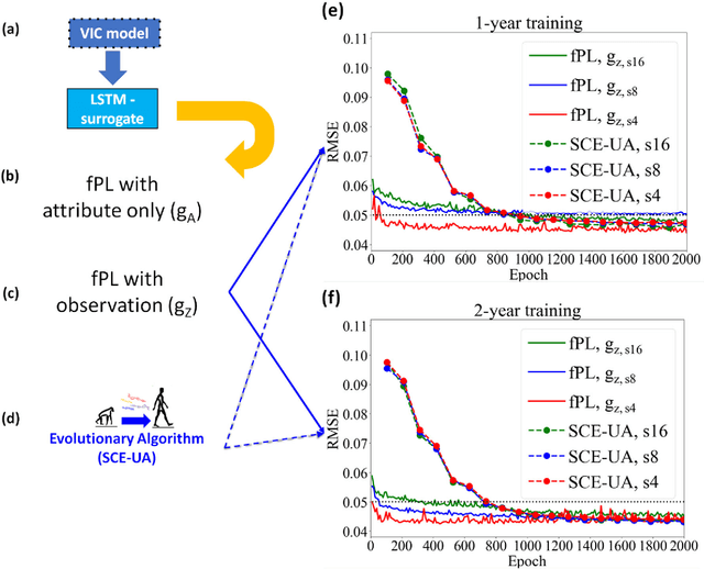
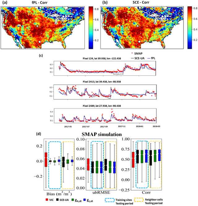
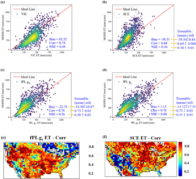
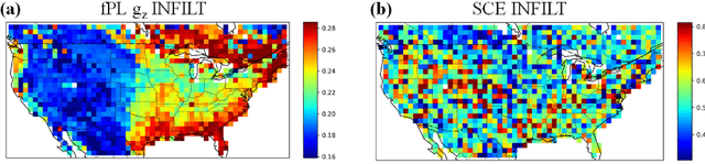
The behaviors and skills of models in many geoscientific domains strongly depend on spatially varying parameters that lack direct observations and must be determined by calibration. Calibration, which solves inverse problems, is a classical but inefficient and stochasticity-ridden approach to reconcile models and observations. Using a widely applied hydrologic model and soil moisture observations as a case study, here we propose a novel, forward-mapping parameter learning (fPL) framework. Whereas evolutionary algorithm (EA)-based calibration solves inversion problems one by one, fPL solves a pattern recognition problem and learns a more robust, universal mapping. fPL can save orders-of-magnitude computational time compared to EA-based calibration, while, surprisingly, producing equivalent ending skill metrics. With more training data, fPL learned across sites and showed super-convergence, scaling much more favorably. Moreover, a more important benefit emerged: fPL produced spatially-coherent parameters in better agreement with physical processes. As a result, it demonstrated better results for out-of-training-set locations and uncalibrated variables. Compared to purely data-driven models, fPL can output unobserved variables, in this case simulated evapotranspiration, which agrees better with satellite-based estimates than the comparison EA. The deep-learning-powered fPL frameworks can be uniformly applied to myriad other geoscientific models. We contend that a paradigm shift from inverse parameter calibration to parameter learning will greatly propel various geoscientific domains.