 Add to Chrome
 Add to Firefox
 Add to Edge
Subnational Geocoding of Global Disasters Using Large Language Models
Nov 13, 2025Subnational location data of disaster events are critical for risk assessment and disaster risk reduction. Disaster databases such as EM-DAT often report locations in unstructured textual form, with inconsistent granularity or spelling, that make it difficult to integrate with spatial datasets. We present a fully automated LLM-assisted workflow that processes and cleans textual location information using GPT-4o, and assigns geometries by cross-checking three independent geoinformation repositories: GADM, OpenStreetMap and Wikidata. Based on the agreement and availability of these sources, we assign a reliability score to each location while generating subnational geometries. Applied to the EM-DAT dataset from 2000 to 2024, the workflow geocodes 14,215 events across 17,948 unique locations. Unlike previous methods, our approach requires no manual intervention, covers all disaster types, enables cross-verification across multiple sources, and allows flexible remapping to preferred frameworks. Beyond the dataset, we demonstrate the potential of LLMs to extract and structure geographic information from unstructured text, offering a scalable and reliable method for related analyses.
A monthly sub-national Harmonized Food Insecurity Dataset for comprehensive analysis and predictive modeling
Jan 13, 2025Food security is a complex, multidimensional concept challenging to measure comprehensively. Effective anticipation, monitoring, and mitigation of food crises require timely and comprehensive global data. This paper introduces the Harmonized Food Insecurity Dataset (HFID), an open-source resource consolidating four key data sources: the Integrated Food Security Phase Classification (IPC)/Cadre Harmonis\'e (CH) phases, the Famine Early Warning Systems Network (FEWS NET) IPC-compatible phases, and the World Food Program's (WFP) Food Consumption Score (FCS) and reduced Coping Strategy Index (rCSI). Updated monthly and using a common reference system for administrative units, the HFID offers extensive spatial and temporal coverage. It serves as a vital tool for food security experts and humanitarian agencies, providing a unified resource for analyzing food security conditions and highlighting global data disparities. The scientific community can also leverage the HFID to develop data-driven predictive models, enhancing the capacity to forecast and prevent future food crises.
Deep Learning Methods for Daily Wildfire Danger Forecasting
Nov 04, 2021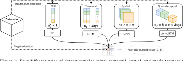
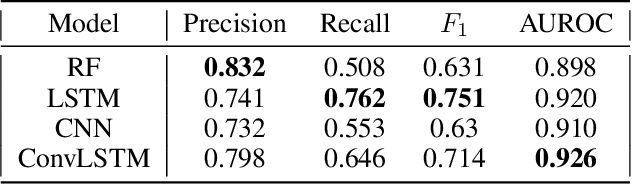
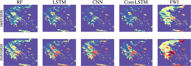
Wildfire forecasting is of paramount importance for disaster risk reduction and environmental sustainability. We approach daily fire danger prediction as a machine learning task, using historical Earth observation data from the last decade to predict next-day's fire danger. To that end, we collect, pre-process and harmonize an open-access datacube, featuring a set of covariates that jointly affect the fire occurrence and spread, such as weather conditions, satellite-derived products, topography features and variables related to human activity. We implement a variety of Deep Learning (DL) models to capture the spatial, temporal or spatio-temporal context and compare them against a Random Forest (RF) baseline. We find that either spatial or temporal context is enough to surpass the RF, while a ConvLSTM that exploits the spatio-temporal context performs best with a test Area Under the Receiver Operating Characteristic of 0.926. Our DL-based proof-of-concept provides national-scale daily fire danger maps at a much higher spatial resolution than existing operational solutions.