 Add to Chrome
 Add to Firefox
 Add to Edge
Beam-Wise Statistical Background Subtraction for Static Roadside LiDAR: A Cross-Sensor Benchmark Study
Aug 14, 2026
Background subtraction is a key preprocessing step for infrastructure-based LiDAR perception, enabling efficient isolation of dynamic traffic participants without semantic annotations. However, systematic cross-sensor evaluations and reproducible studies for static roadside LiDAR are missing. This paper presents a comparative benchmark of beam-wise statistical background subtraction for statically mounted LiDAR sensors. We formulate background estimation as a per-beam temporal modeling problem and investigate complementary statistical strategies that capture dominant as well as multi-modal background structures, combined with spatial filtering in the angular and 3D domain. To enable reproducible evaluation, we introduce HighwayScene, a new multi-LiDAR dataset recorded in a static roadside setup, and extend the public CoopScenes dataset with static/dynamic point-wise annotations. Across multiple scenes and heterogeneous sensing technologies, we demonstrate that beam-wise statistical modeling provides a robust and transferable solution. Combining lightweight per-beam models with spatial consistency filtering substantially improves precision while maintaining high recall and real-time capability. All datasets, annotations, and implementations are publicly released.

StixelNExT++: Lightweight Monocular Scene Segmentation and Representation for Collective Perception
Jul 09, 2025This paper presents StixelNExT++, a novel approach to scene representation for monocular perception systems. Building on the established Stixel representation, our method infers 3D Stixels and enhances object segmentation by clustering smaller 3D Stixel units. The approach achieves high compression of scene information while remaining adaptable to point cloud and bird's-eye-view representations. Our lightweight neural network, trained on automatically generated LiDAR-based ground truth, achieves real-time performance with computation times as low as 10 ms per frame. Experimental results on the Waymo dataset demonstrate competitive performance within a 30-meter range, highlighting the potential of StixelNExT++ for collective perception in autonomous systems.
The OPNV Data Collection: A Dataset for Infrastructure-Supported Perception Research with Focus on Public Transportation
Jul 11, 2024This paper we present our vision and ongoing work for a novel dataset designed to advance research into the interoperability of intelligent vehicles and infrastructure, specifically aimed at enhancing cooperative perception and interaction in the realm of public transportation. Unlike conventional datasets centered on ego-vehicle data, this approach encompasses both a stationary sensor tower and a moving vehicle, each equipped with cameras, LiDARs, and GNSS, while the vehicle additionally includes an inertial navigation system. Our setup features comprehensive calibration and time synchronization, ensuring seamless and accurate sensor data fusion crucial for studying complex, dynamic scenes. Emphasizing public transportation, the dataset targets to include scenes like bus station maneuvers and driving on dedicated bus lanes, reflecting the specifics of small public buses. We introduce the open-source ".4mse" file format for the new dataset, accompanied by a research kit. This kit provides tools such as ego-motion compensation or LiDAR-to-camera projection enabling advanced research on intelligent vehicle-infrastructure integration. Our approach does not include annotations; however, we plan to implement automatically generated labels sourced from state-of-the-art public repositories. Several aspects are still up for discussion, and timely feedback from the community would be greatly appreciated. A sneak preview on one data frame will be available at a Google Colab Notebook. Moreover, we will use the related GitHub Repository to collect remarks and suggestions.
StixelNExT: Toward Monocular Low-Weight Perception for Object Segmentation and Free Space Detection
Jul 11, 2024


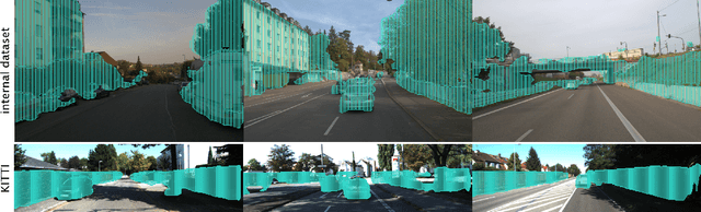
In this work, we present a novel approach for general object segmentation from a monocular image, eliminating the need for manually labeled training data and enabling rapid, straightforward training and adaptation with minimal data. Our model initially learns from LiDAR during the training process, which is subsequently removed from the system, allowing it to function solely on monocular imagery. This study leverages the concept of the Stixel-World to recognize a medium level representation of its surroundings. Our network directly predicts a 2D multi-layer Stixel-World and is capable of recognizing and locating multiple, superimposed objects within an image. Due to the scarcity of comparable works, we have divided the capabilities into modules and present a free space detection in our experiments section. Furthermore, we introduce an improved method for generating Stixels from LiDAR data, which we use as ground truth for our network.