 Add to Chrome
 Add to Firefox
 Add to Edge
Classifications of the Summative Assessment for Revised Blooms Taxonomy by using Deep Learning
Apr 18, 2021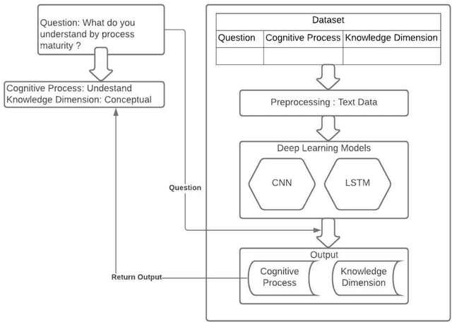
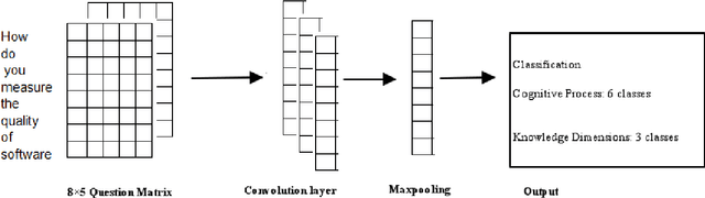

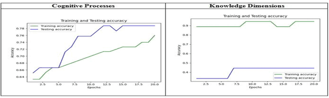
Education is the basic step of understanding the truth and the preparation of the intelligence to reflect. Focused on the rational capacity of the human being the Cognitive process and knowledge dimensions of Revised Blooms Taxonomy helps to differentiate the procedure of studying into six types of various cognitive processes and four types of knowledge dimensions. These types are synchronized in the increasing level of difficulty. In this paper Software Engineering courses of B.Tech Computer Engineering and Information Technology offered by various Universities and Educational Institutes have been investigated for Revised Blooms Taxonomy RBT. Questions are a very useful constituent. Knowledge intelligence and strength of the learners can be tested by applying questions.The fundamental goal of this paper is to create a relative study of the classification of the summative assessment based on Revised Blooms Taxonomy using the Convolutional Neural Networks CNN Long Short-Term Memory LSTM of Deep Learning techniques in an endeavor to attain significant accomplishment and elevated precision levels.
* 8 pages, 7 figures, 2 tables
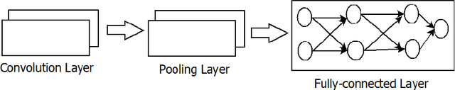
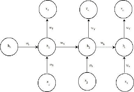
Deep Learning Techniques for Geospatial Data Analysis
Aug 30, 2020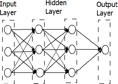
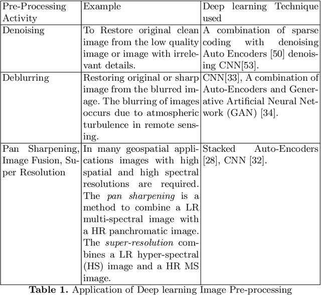
Consumer electronic devices such as mobile handsets, goods tagged with RFID labels, location and position sensors are continuously generating a vast amount of location enriched data called geospatial data. Conventionally such geospatial data is used for military applications. In recent times, many useful civilian applications have been designed and deployed around such geospatial data. For example, a recommendation system to suggest restaurants or places of attraction to a tourist visiting a particular locality. At the same time, civic bodies are harnessing geospatial data generated through remote sensing devices to provide better services to citizens such as traffic monitoring, pothole identification, and weather reporting. Typically such applications are leveraged upon non-hierarchical machine learning techniques such as Naive-Bayes Classifiers, Support Vector Machines, and decision trees. Recent advances in the field of deep-learning showed that Neural Network-based techniques outperform conventional techniques and provide effective solutions for many geospatial data analysis tasks such as object recognition, image classification, and scene understanding. The chapter presents a survey on the current state of the applications of deep learning techniques for analyzing geospatial data. The chapter is organized as below: (i) A brief overview of deep learning algorithms. (ii)Geospatial Analysis: a Data Science Perspective (iii) Deep-learning techniques for Remote Sensing data analytics tasks (iv) Deep-learning techniques for GPS data analytics(iv) Deep-learning techniques for RFID data analytics.
* This is a pre-print of the following chapter: Arvind W. Kiwelekar, Geetanjali S. Mahamunkar, Laxman D. Netak, Valmik B Nikam, {\em Deep Learning Techniques for Geospatial Data Analysis}, published in {\bf Machine Learning Paradigms}, edited by George A. TsihrintzisLakhmi C. Jain, 2020, publisher Springer, Cham reproduced with permission of publisher Springer, Cham