 Add to Chrome
 Add to Firefox
 Add to Edge
Rigid-Covert GNSS Spoofing of UAV Swarms: A Structural Blind Spot, Its Detection Limit, and Absolute-Anchor Defenses
Aug 07, 2026
Cooperative UAV-swarm defenses commonly cross-check GNSS positions against measured inter-drone geometry. We show that this relative-geometry channel has a structural blind spot: a common, slowly varying translation (a rigid-covert shift, RigidShift) preserves all pairwise distances and is therefore unobservable to any relative-only detector (a gauge-freedom argument). We validate this blindness on distance-verification and semidefinite-feasibility baselines, while explicitly distinguishing it from onboard inertial/GNSS monitors that can raise a bare alarm but cannot recover the swarm's true position. To quantify when an external reference restores observability, we derive the drift-dependent detection floor $2γ/(1-t_s/T)$ for a calibrated anchor-residual detector and empirically identify an additional detector-specific noise floor (measured slope 2.66 vs. predicted 2.67). We then present a centralized anchor-rooted recovery pipeline that reconstructs swarm geometry from inter-drone ranges, aligns it to a trusted-anchor subset with Byzantine-robust fitting, and recovers the absolute positions of non-anchored drones. A segmented estimator jointly estimates anchor drift, attack rate, and onset when no clean-epoch label is available. Across statistical simulations, ArduPilot software-in-the-loop experiments, and Gazebo experiments with rendered vision anchors, the method recovers the positions of non-anchored drones to a median error of 0.39 m (20 seeds) under approximately 10.1 m of GNSS drift, and to 7.1 cm (5 seeds) in the rendered-vision multi-SITL setting. We also characterize the explicit limits imposed by non-collinear anchor geometry, anchor coverage, $τ\to0$ drift-attack aliasing, and majority anchor compromise. All evaluations are simulation-based and use no RF spoofing hardware or physical swarm.

Versatile and Fast Location-Based Private Information Retrieval with Fully Homomorphic Encryption over the Torus
Jun 15, 2025Location-based services often require users to share sensitive locational data, raising privacy concerns due to potential misuse or exploitation by untrusted servers. In response, we present VeLoPIR, a versatile location-based private information retrieval (PIR) system designed to preserve user privacy while enabling efficient and scalable query processing. VeLoPIR introduces three operational modes-interval validation, coordinate validation, and identifier matching-that support a broad range of real-world applications, including information and emergency alerts. To enhance performance, VeLoPIR incorporates multi-level algorithmic optimizations with parallel structures, achieving significant scalability across both CPU and GPU platforms. We also provide formal security and privacy proofs, confirming the system's robustness under standard cryptographic assumptions. Extensive experiments on real-world datasets demonstrate that VeLoPIR achieves up to 11.55 times speed-up over a prior baseline. The implementation of VeLoPIR is publicly available at https://github.com/PrivStatBool/VeLoPIR.
Speed-up of Data Analysis with Kernel Trick in Encrypted Domain
Jun 14, 2024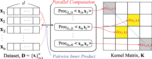
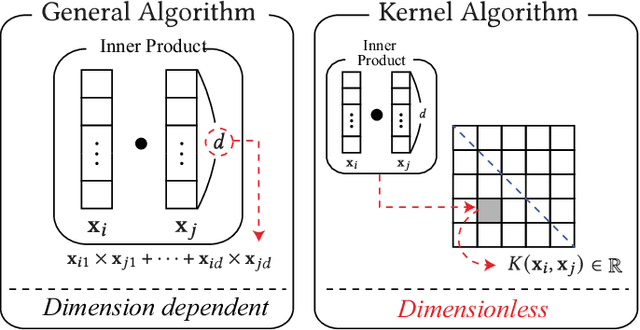
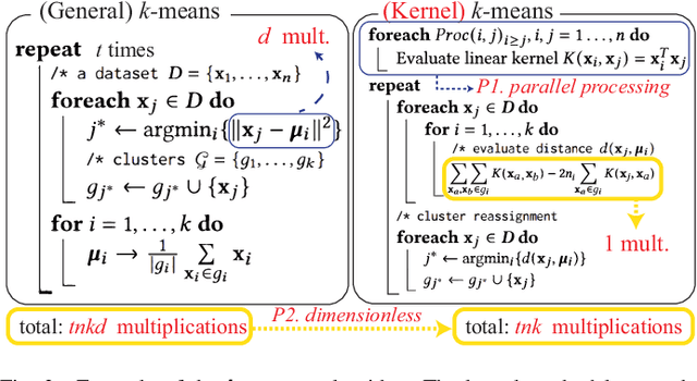
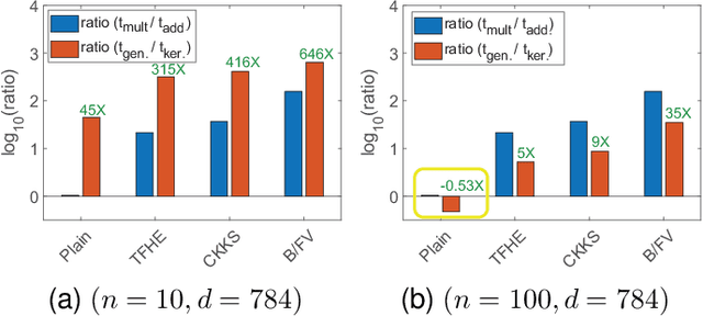
Homomorphic encryption (HE) is pivotal for secure computation on encrypted data, crucial in privacy-preserving data analysis. However, efficiently processing high-dimensional data in HE, especially for machine learning and statistical (ML/STAT) algorithms, poses a challenge. In this paper, we present an effective acceleration method using the kernel method for HE schemes, enhancing time performance in ML/STAT algorithms within encrypted domains. This technique, independent of underlying HE mechanisms and complementing existing optimizations, notably reduces costly HE multiplications, offering near constant time complexity relative to data dimension. Aimed at accessibility, this method is tailored for data scientists and developers with limited cryptography background, facilitating advanced data analysis in secure environments.