 Add to Chrome
 Add to Firefox
 Add to Edge
SatDM: Synthesizing Realistic Satellite Image with Semantic Layout Conditioning using Diffusion Models
Sep 28, 2023Deep learning models in the Earth Observation domain heavily rely on the availability of large-scale accurately labeled satellite imagery. However, obtaining and labeling satellite imagery is a resource-intensive endeavor. While generative models offer a promising solution to address data scarcity, their potential remains underexplored. Recently, Denoising Diffusion Probabilistic Models (DDPMs) have demonstrated significant promise in synthesizing realistic images from semantic layouts. In this paper, a conditional DDPM model capable of taking a semantic map and generating high-quality, diverse, and correspondingly accurate satellite images is implemented. Additionally, a comprehensive illustration of the optimization dynamics is provided. The proposed methodology integrates cutting-edge techniques such as variance learning, classifier-free guidance, and improved noise scheduling. The denoising network architecture is further complemented by the incorporation of adaptive normalization and self-attention mechanisms, enhancing the model's capabilities. The effectiveness of our proposed model is validated using a meticulously labeled dataset introduced within the context of this study. Validation encompasses both algorithmic methods such as Frechet Inception Distance (FID) and Intersection over Union (IoU), as well as a human opinion study. Our findings indicate that the generated samples exhibit minimal deviation from real ones, opening doors for practical applications such as data augmentation. We look forward to further explorations of DDPMs in a wider variety of settings and data modalities. An open-source reference implementation of the algorithm and a link to the benchmarked dataset are provided at https://github.com/obaghirli/syn10-diffusion.
Greenhouse Segmentation on High-Resolution Optical Satellite Imagery using Deep Learning Techniques
Jul 22, 2020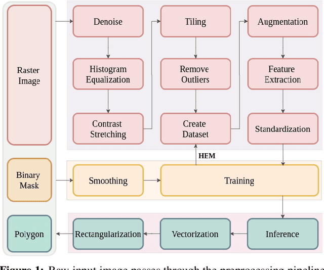
Greenhouse segmentation has pivotal importance for climate-smart agricultural land-use planning. Deep learning-based approaches provide state-of-the-art performance in natural image segmentation. However, semantic segmentation on high-resolution optical satellite imagery is a challenging task because of the complex environment. In this paper, a sound methodology is proposed for pixel-wise classification on images acquired by the Azersky (SPOT-7) optical satellite. In particular, customized variations of U-Net-like architectures are employed to identify greenhouses. Two models are proposed which uniquely incorporate dilated convolutions and skip connections, and the results are compared to that of the baseline U-Net model. The dataset used consists of pan-sharpened orthorectified Azersky images (red, green, blue,and near infrared channels) with 1.5-meter resolution and annotation masks, collected from 15 regions in Azerbaijan where the greenhouses are densely congested. The images cover the cumulative area of 1008 $km^2$ and annotation masks contain 47559 polygons in total. The $F_1, Kappa, AUC$, and $IOU$ scores are used for performance evaluation. It is observed that the use of the deconvolutional layers alone throughout the expansive path does not yield satisfactory results; therefore, they are either replaced or coupled with bilinear interpolation. All models benefit from the hard example mining (HEM) strategy. It is also reported that the best accuracy of $93.29\%$ ($F_1\,score$) is recorded when the weighted binary cross-entropy loss is coupled with the dice loss. Experimental results showed that both of the proposed models outperformed the baseline U-Net architecture such that the best model proposed scored $4.48\%$ higher in comparison to the baseline architecture.