 Add to Chrome
 Add to Firefox
 Add to Edge
Towards Physically-Based Sky-Modeling For Image Based Lighting
Dec 15, 2025Accurate environment maps are a key component for rendering photorealistic outdoor scenes with coherent illumination. They enable captivating visual arts, immersive virtual reality, and a wide range of engineering and scientific applications. Recent works have extended sky-models to be more comprehensive and inclusive of cloud formations but, as we demonstrate, existing methods fall short in faithfully recreating natural skies. Though in recent years the visual quality of DNN-generated High Dynamic Range Imagery (HDRI) has greatly improved, the environment maps generated by DNN sky-models do not re-light scenes with the same tones, shadows, and illumination as physically captured HDR imagery. In this work, we demonstrate progress in HDR literature to be tangential to sky-modelling as current works cannot support both photorealism and the 22 f-stops required for the Full Dynamic Range (FDR) of outdoor illumination. We achieve this by proposing AllSky, a flexible all-weather sky-model learned directly from physically captured HDRI which we leverage to study the input modalities, tonemapping, conditioning, and evaluation of sky-models. Per user-controlled positioning of the sun and cloud formations, AllSky expands on current functionality by allowing for intuitive user control over environment maps and achieves state-of-the-art sky-model performance. Through our proposed evaluation, we demonstrate existing DNN sky-models are not interchangeable with physically captured HDRI or parametric sky-models, with current limitations being prohibitive of scalability and accurate illumination in downstream applications
Towards Physically-Based Sky-Modeling
Dec 16, 2024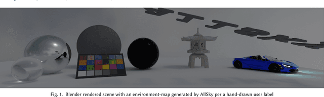
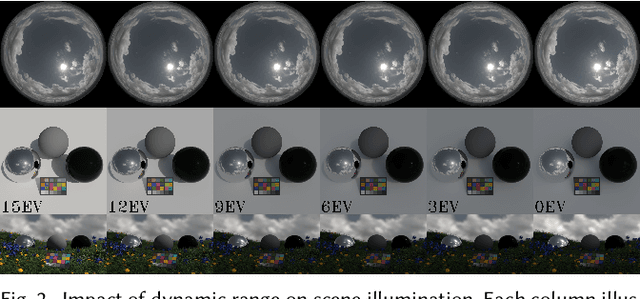
Accurate environment maps are a key component in rendering photorealistic outdoor scenes with coherent illumination. They enable captivating visual arts, immersive virtual reality and a wide range of engineering and scientific applications. Recent works have extended sky-models to be more comprehensive and inclusive of cloud formations but existing approaches fall short in faithfully recreating key-characteristics in physically captured HDRI. As we demonstrate, environment maps produced by sky-models do not relight scenes with the same tones, shadows, and illumination coherence as physically captured HDR imagery. Though the visual quality of DNN-generated LDR and HDR imagery has greatly progressed in recent years, we demonstrate this progress to be tangential to sky-modelling. Due to the Extended Dynamic Range (EDR) of 14EV required for outdoor environment maps inclusive of the sun, sky-modelling extends beyond the conventional paradigm of High Dynamic Range Imagery (HDRI). In this work, we propose an all-weather sky-model, learning weathered-skies directly from physically captured HDR imagery. Per user-controlled positioning of the sun and cloud formations, our model (AllSky) allows for emulation of physically captured environment maps with improved retention of the Extended Dynamic Range (EDR) of the sky.
Spatial Perspective Transform Estimation from Fourier Spectrum Analysis of 2D Patterns in 3D Space
Nov 27, 2022A novel approach to 3D surface imaging is proposed, allowing for the continuous sampling of 3D surfaces to extract localized perspective transformation coefficients from Fourier spectrum analysis of projected patterns. The mathematical relationship for Spatial-Fourier Transformation Pairs is derived, defining the transformation of spatial transformed planar surfaces in the Discrete Fourier Transform spectrum. The mathematical relationship for the twelve degrees of freedom in perspective transformation is defined and validated, asserting congruity with independent and uniform transform pairs for spatial Euclidean, similarity, affine and perspective transformations. This work expands on previously derived affine Spatial-Fourier Transformation Pairs and characterizes its implications towards 3D surface imaging as a means of augmenting (X,Y,Z)-(R,G,B) point-clouds to include additional information from localized sampling of pattern transformations.