 Add to Chrome
 Add to Firefox
 Add to Edge
LitS: A novel Neighborhood Descriptor for Point Clouds
Feb 04, 2026With the advancement of 3D scanning technologies, point clouds have become fundamental for representing 3D spatial data, with applications that span across various scientific and technological fields. Practical analysis of this data depends crucially on available neighborhood descriptors to accurately characterize the local geometries of the point cloud. This paper introduces LitS, a novel neighborhood descriptor for 2D and 3D point clouds. LitS are piecewise constant functions on the unit circle that allow points to keep track of their surroundings. Each element in LitS' domain represents a direction with respect to a local reference system. Once constructed, evaluating LitS at any given direction gives us information about the number of neighbors in a cone-like region centered around that same direction. Thus, LitS conveys a lot of information about the local neighborhood of a point, which can be leveraged to gain global structural understanding by analyzing how LitS changes between close points. In addition, LitS comes in two versions ('regular' and 'cumulative') and has two parameters, allowing them to adapt to various contexts and types of point clouds. Overall, they are a versatile neighborhood descriptor, capable of capturing the nuances of local point arrangements and resilient to common point cloud data issues such as variable density and noise.
ALICE-LRI: A General Method for Lossless Range Image Generation for Spinning LiDAR Sensors without Calibration Metadata
Oct 23, 2025
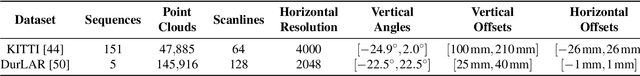


3D LiDAR sensors are essential for autonomous navigation, environmental monitoring, and precision mapping in remote sensing applications. To efficiently process the massive point clouds generated by these sensors, LiDAR data is often projected into 2D range images that organize points by their angular positions and distances. While these range image representations enable efficient processing, conventional projection methods suffer from fundamental geometric inconsistencies that cause irreversible information loss, compromising high-fidelity applications. We present ALICE-LRI (Automatic LiDAR Intrinsic Calibration Estimation for Lossless Range Images), the first general, sensor-agnostic method that achieves lossless range image generation from spinning LiDAR point clouds without requiring manufacturer metadata or calibration files. Our algorithm automatically reverse-engineers the intrinsic geometry of any spinning LiDAR sensor by inferring critical parameters including laser beam configuration, angular distributions, and per-beam calibration corrections, enabling lossless projection and complete point cloud reconstruction with zero point loss. Comprehensive evaluation across the complete KITTI and DurLAR datasets demonstrates that ALICE-LRI achieves perfect point preservation, with zero points lost across all point clouds. Geometric accuracy is maintained well within sensor precision limits, establishing geometric losslessness with real-time performance. We also present a compression case study that validates substantial downstream benefits, demonstrating significant quality improvements in practical applications. This paradigm shift from approximate to lossless LiDAR projections opens new possibilities for high-precision remote sensing applications requiring complete geometric preservation.