 Add to Chrome
 Add to Firefox
 Add to Edge
Estimating Solar Irradiance Using Sky Imagers
Oct 11, 2019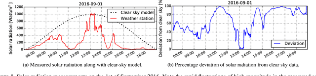
Ground-based whole sky cameras are extensively used for localized monitoring of clouds nowadays. They capture hemispherical images of the sky at regular intervals using a fisheye lens. In this paper, we propose a framework for estimating solar irradiance from pictures taken by those imagers. Unlike pyranometers, such sky images contain information about cloud coverage and can be used to derive cloud movement. An accurate estimation of solar irradiance using solely those images is thus a first step towards short-term forecasting of solar energy generation based on cloud movement. We derive and validate our model using pyranometers co-located with our whole sky imagers. We achieve a better performance in estimating solar irradiance and in particular its short-term variations as compared to other related methods using ground-based observations.
High-Dynamic-Range Imaging for Cloud Segmentation
Mar 02, 2018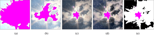
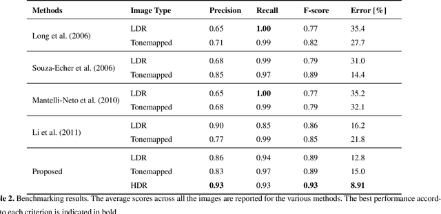
Sky/cloud images obtained from ground-based sky-cameras are usually captured using a fish-eye lens with a wide field of view. However, the sky exhibits a large dynamic range in terms of luminance, more than a conventional camera can capture. It is thus difficult to capture the details of an entire scene with a regular camera in a single shot. In most cases, the circumsolar region is over-exposed, and the regions near the horizon are under-exposed. This renders cloud segmentation for such images difficult. In this paper, we propose HDRCloudSeg -- an effective method for cloud segmentation using High-Dynamic-Range (HDR) imaging based on multi-exposure fusion. We describe the HDR image generation process and release a new database to the community for benchmarking. Our proposed approach is the first using HDR radiance maps for cloud segmentation and achieves very good results.
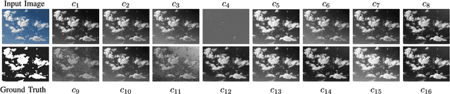
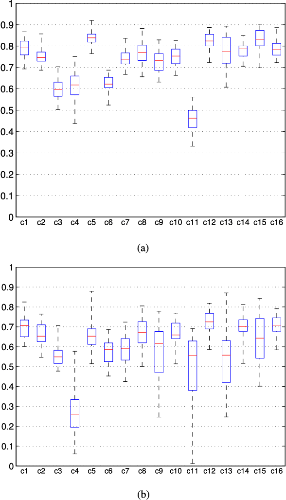
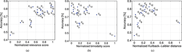
Nighttime sky/cloud image segmentation
May 30, 2017
Imaging the atmosphere using ground-based sky cameras is a popular approach to study various atmospheric phenomena. However, it usually focuses on the daytime. Nighttime sky/cloud images are darker and noisier, and thus harder to analyze. An accurate segmentation of sky/cloud images is already challenging because of the clouds' non-rigid structure and size, and the lower and less stable illumination of the night sky increases the difficulty. Nonetheless, nighttime cloud imaging is essential in certain applications, such as continuous weather analysis and satellite communication. In this paper, we propose a superpixel-based method to segment nighttime sky/cloud images. We also release the first nighttime sky/cloud image segmentation database to the research community. The experimental results show the efficacy of our proposed algorithm for nighttime images.
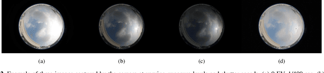
Design of low-cost, compact and weather-proof whole sky imagers for high-dynamic-range captures
Apr 19, 2017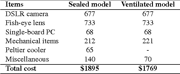
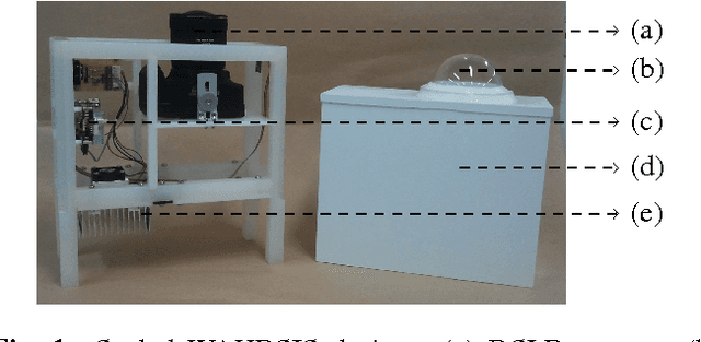
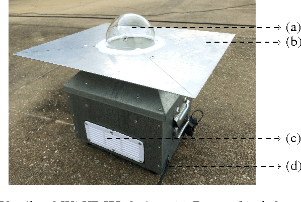
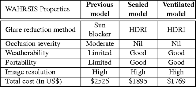
Ground-based whole sky imagers are popular for monitoring cloud formations, which is necessary for various applications. We present two new Wide Angle High-Resolution Sky Imaging System (WAHRSIS) models, which were designed especially to withstand the hot and humid climate of Singapore. The first uses a fully sealed casing, whose interior temperature is regulated using a Peltier cooler. The second features a double roof design with ventilation grids on the sides, allowing the outside air to flow through the device. Measurements of temperature inside these two devices show their ability to operate in Singapore weather conditions. Unlike our original WAHRSIS model, neither uses a mechanical sun blocker to prevent the direct sunlight from reaching the camera; instead they rely on high-dynamic-range imaging (HDRI) techniques to reduce the glare from the sun.
WAHRSIS: A Low-cost, High-resolution Whole Sky Imager With Near-Infrared Capabilities
Apr 19, 2017Cloud imaging using ground-based whole sky imagers is essential for a fine-grained understanding of the effects of cloud formations, which can be useful in many applications. Some such imagers are available commercially, but their cost is relatively high, and their flexibility is limited. Therefore, we built a new daytime Whole Sky Imager (WSI) called Wide Angle High-Resolution Sky Imaging System. The strengths of our new design are its simplicity, low manufacturing cost and high resolution. Our imager captures the entire hemisphere in a single high-resolution picture via a digital camera using a fish-eye lens. The camera was modified to capture light across the visible as well as the near-infrared spectral ranges. This paper describes the design of the device as well as the geometric and radiometric calibration of the imaging system.
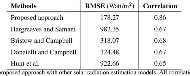
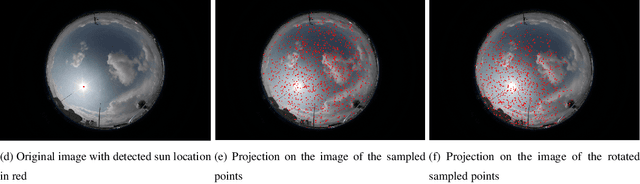
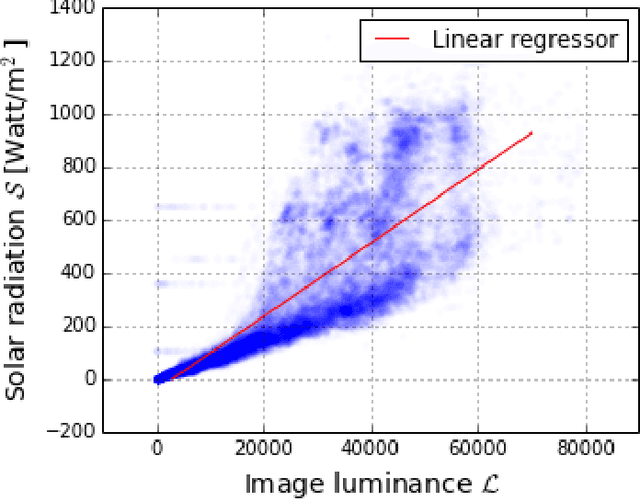
Estimation of solar irradiance using ground-based whole sky imagers
Apr 06, 2017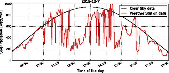
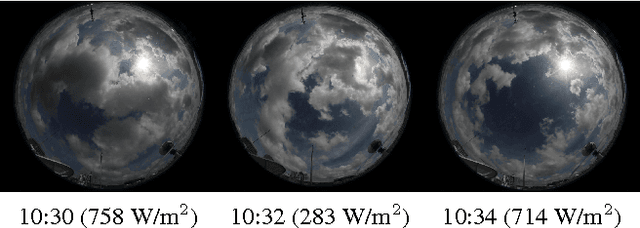
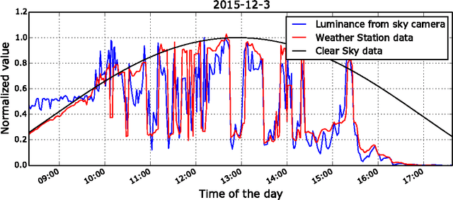
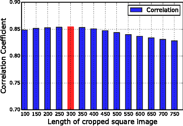
Ground-based whole sky imagers (WSIs) can provide localized images of the sky of high temporal and spatial resolution, which permits fine-grained cloud observation. In this paper, we show how images taken by WSIs can be used to estimate solar radiation. Sky cameras are useful here because they provide additional information about cloud movement and coverage, which are otherwise not available from weather station data. Our setup includes ground-based weather stations at the same location as the imagers. We use their measurements to validate our methods.
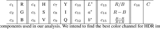
Rough Set Based Color Channel Selection
Nov 03, 2016
Color channel selection is essential for accurate segmentation of sky and clouds in images obtained from ground-based sky cameras. Most prior works in cloud segmentation use threshold based methods on color channels selected in an ad-hoc manner. In this letter, we propose the use of rough sets for color channel selection in visible-light images. Our proposed approach assesses color channels with respect to their contribution for segmentation, and identifies the most effective ones.
Short-term prediction of localized cloud motion using ground-based sky imagers
Oct 21, 2016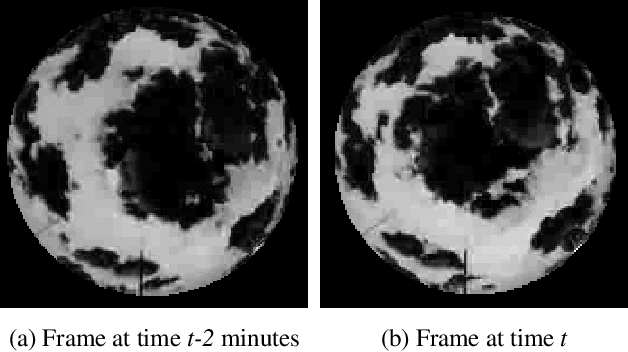
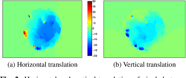
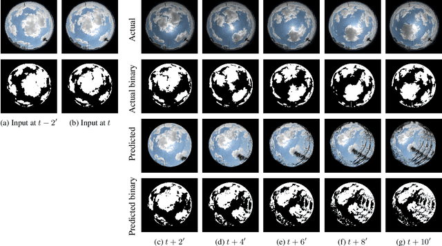
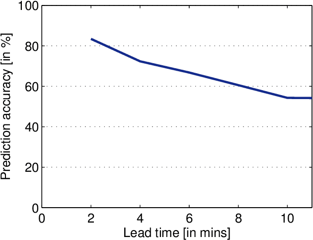
Fine-scale short-term cloud motion prediction is needed for several applications, including solar energy generation and satellite communications. In tropical regions such as Singapore, clouds are mostly formed by convection; they are very localized, and evolve quickly. We capture hemispherical images of the sky at regular intervals of time using ground-based cameras. They provide a high resolution and localized cloud images. We use two successive frames to compute optical flow and predict the future location of clouds. We achieve good prediction accuracy for a lead time of up to 5 minutes.