 Add to Chrome
 Add to Firefox
 Add to Edge
Groningen: Spatial Prediction of Rock Gas Saturation by Leveraging Selected and Augmented Well and Seismic Data with Classifier Ensembles
Oct 14, 2024This paper presents a proof of concept for spatial prediction of rock saturation probability using classifier ensemble methods on the example of the giant Groningen gas field. The stages of generating 1481 seismic field attributes and selecting 63 significant attributes are described. The effectiveness of the proposed method of augmentation of well and seismic data is shown, which increased the training sample by 9 times. On a test sample of 42 wells (blind well test), the results demonstrate good accuracy in predicting the ensemble of classifiers: the Matthews correlation coefficient is 0.7689, and the F1-score for the "gas reservoir" class is 0.7949. Prediction of gas reservoir thicknesses within the field and adjacent areas is made.
Gas trap prediction from 3D seismic and well test data using machine learning
Jan 23, 2024The aim of this work is to create and apply a methodological approach for predicting gas traps from 3D seismic data and gas well testing. The paper formalizes the approach to creating a training dataset by selecting volumes with established gas saturation and filtration properties within the seismic wavefield. The training dataset thus created is used in a process stack of sequential application of data processing methods and ensemble machine learning algorithms. As a result, a cube of calibrated probabilities of belonging of the study space to gas reservoirs was obtained. The high efficiency of this approach is shown on a delayed test sample of three wells (blind wells). The final value of the gas reservoir prediction quality metric f1 score was 0.893846.
Expert-Independent Generalization of Well and Seismic Data Using Machine Learning Methods for Complex Reservoirs Predicting During Early-Stage Geological Exploration
Apr 06, 2023


The aim of this study is to develop and apply an autonomous approach for predicting the probability of hydrocarbon reservoirs spreading in the studied area. Autonomy means that after preparing and inputting geological-geophysical information, the influence of an expert on the algorithms is minimized. The study was made based on the 3D seismic survey data and well information on the early exploration stage of the studied field. As a result, a forecast of the probability of spatial distribution of reservoirs was made for two sets of input data: the base set and the set after reverse-calibration, and three-dimensional cubes of calibrated probabilities of belonging of the studied space to the identified classes were obtained. The approach presented in the paper allows for expert-independent generalization of geological and geophysical data, and to use this generalization for hypothesis testing and creating geological models based on a probabilistic representation of the reservoir. The quality of the probabilistic representation depends on the quality and quantity of the input data. Depending on the input data, the approach can be a useful tool for exploration and prospecting of geological objects, identifying potential resources, optimizing and designing field development.
Reservoir Prediction by Machine Learning Methods on The Well Data and Seismic Attributes for Complex Coastal Conditions
Jan 09, 2023The aim of this work was to predict the probability of the spread of rock formations with hydrocarbon-collecting properties in the studied coastal area using a stack of machine learning algorithms and data augmentation and modification methods. This research develops the direction of machine learning where training is conducted on well data and spatial attributes. Methods for overcoming the limitations of this direction are shown, two methods - augmentation and modification of the well data sample: Spindle and Revers-Calibration. Considering the difficulties for seismic data interpretation in coastal area conditions, the proposed approach is a tool which is able to work with the whole totality of geological and geophysical data, extract the knowledge from 159-dimensional space spatial attributes and make facies spreading prediction with acceptable quality - F1 measure for reservoir class 0.798 on average for evaluation of "drilling" results of different geological conditions. It was shown that consistent application of the proposed augmentation methods in the implemented technology stack improves the quality of reservoir prediction by a factor of 1.56 relative to the original dataset.
Subsurface Depths Structure Maps Reconstruction with Generative Adversarial Networks
Jun 15, 2022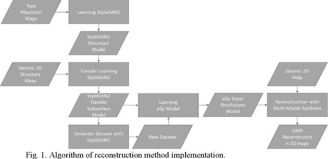
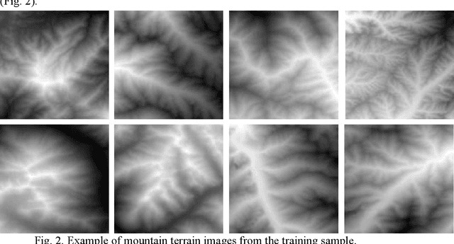
This paper described a method for reconstruction of detailed-resolution depth structure maps, usually obtained after the 3D seismic surveys, using the data from 2D seismic depth maps. The method uses two algorithms based on the generative-adversarial neural network architecture. The first algorithm StyleGAN2-ADA accumulates in the hidden space of the neural network the semantic images of mountainous terrain forms first, and then with help of transfer learning, in the ideal case - the structure geometry of stratigraphic horizons. The second algorithm, the Pixel2Style2Pixel encoder, using the semantic level of generalization of the first algorithm, learns to reconstruct the original high-resolution images from their degraded copies (super-resolution technology). There was demonstrated a methodological approach to transferring knowledge on the structural forms of stratigraphic horizon boundaries from the well-studied areas to the underexplored ones. Using the multimodal synthesis of Pixel2Style2Pixel encoder, it is proposed to create a probabilistic depth space, where each point of the project area is represented by the density of probabilistic depth distribution of equally probable reconstructed geological forms of structural images. Assessment of the reconstruction quality was carried out for two blocks. Using this method, credible detailed depth reconstructions comparable with the quality of 3D seismic maps have been obtained from 2D seismic maps.
Prediction of geophysical properties of rocks on rare well data and attributes of seismic waves by machine learning methods on the example of the Achimov formation
Jun 24, 2021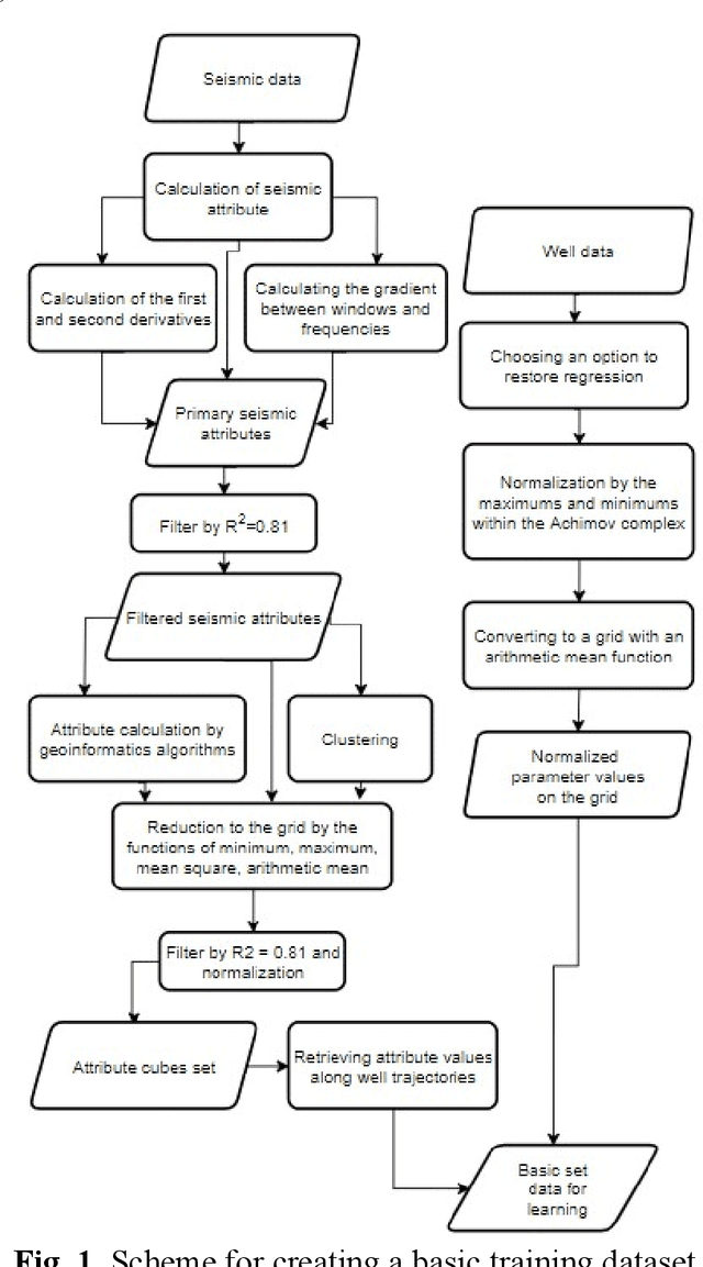
Purpose of this research is to forecast the development of sand bodies in productive sediments based on well log data and seismic attributes. The object of the study is the productive intervals of Achimov sedimentary complex in the part of oil field located in Western Siberia. The research shows a technological stack of machine learning algorithms, methods for enriching the source data with synthetic ones and algorithms for creating new features. The result was the model of regression relationship between the values of natural radioactivity of rocks and seismic wave field attributes with an acceptable prediction quality. Acceptable quality of the forecast is confirmed both by model cross validation, and by the data obtained following the results of new well.