 Add to Chrome
 Add to Firefox
 Add to Edge
Comparison of machine learning and statistical approaches for digital elevation model (DEM) correction: interim results
Feb 08, 2024
Several methods have been proposed for correcting the elevation bias in digital elevation models (DEMs) for example, linear regression. Nowadays, supervised machine learning enables the modelling of complex relationships between variables, and has been deployed by researchers in a variety of fields. In the existing literature, several studies have adopted either machine learning or statistical approaches in the task of DEM correction. However, to our knowledge, none of these studies have compared the performance of both approaches, especially with regard to open-access global DEMs. Our previous work has already shown the potential of machine learning approaches, specifically gradient boosted decision trees (GBDTs) for DEM correction. In this study, we share some results from the comparison of three recent implementations of gradient boosted decision trees (XGBoost, LightGBM and CatBoost), versus multiple linear regression (MLR) for enhancing the vertical accuracy of 30 m Copernicus and AW3D global DEMs in Cape Town, South Africa.
Digital elevation model correction in urban areas using extreme gradient boosting, land cover and terrain parameters
Aug 12, 2023


The accuracy of digital elevation models (DEMs) in urban areas is influenced by numerous factors including land cover and terrain irregularities. Moreover, building artifacts in global DEMs cause artificial blocking of surface flow pathways. This compromises their quality and adequacy for hydrological and environmental modelling in urban landscapes where precise and accurate terrain information is needed. In this study, the extreme gradient boosting (XGBoost) ensemble algorithm is adopted for enhancing the accuracy of two medium-resolution 30m DEMs over Cape Town, South Africa: Copernicus GLO-30 and ALOS World 3D (AW3D). XGBoost is a scalable, portable and versatile gradient boosting library that can solve many environmental modelling problems. The training datasets are comprised of eleven predictor variables including elevation, urban footprints, slope, aspect, surface roughness, topographic position index, terrain ruggedness index, terrain surface texture, vector roughness measure, forest cover and bare ground cover. The target variable (elevation error) was calculated with respect to highly accurate airborne LiDAR. After training and testing, the model was applied for correcting the DEMs at two implementation sites. The correction achieved significant accuracy gains which are competitive with other proposed methods. The root mean square error (RMSE) of Copernicus DEM improved by 46 to 53% while the RMSE of AW3D DEM improved by 72 to 73%. These results showcase the potential of gradient boosted trees for enhancing the quality of DEMs, and for improved hydrological modelling in urban catchments.
A systematic review and meta-analysis of Digital Elevation Model fusion: pre-processing, methods and applications
Apr 08, 2022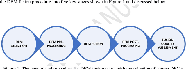

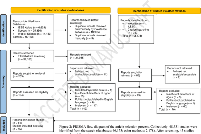
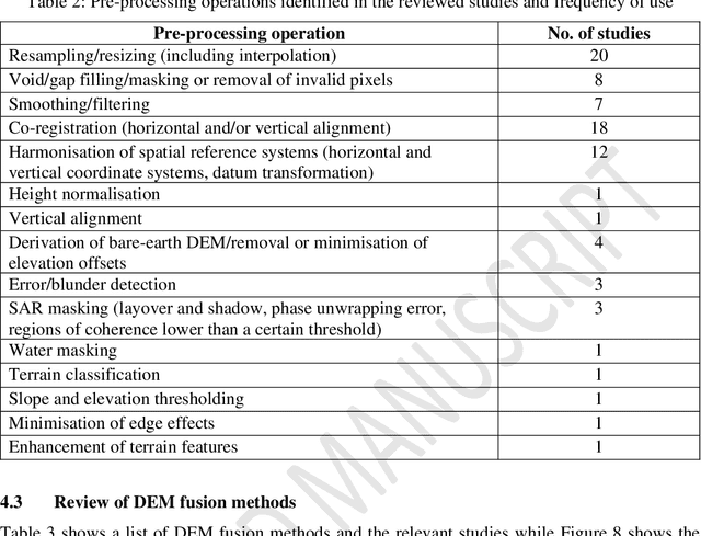
The remote sensing community has identified data fusion as one of the key challenging topics of the 21st century. The subject of image fusion in two-dimensional (2D) space has been covered in several published reviews. However, the special case of 2.5D/3D Digital Elevation Model (DEM) fusion has not been addressed till date. DEM fusion is a key application of data fusion in remote sensing. It takes advantage of the complementary characteristics of multi-source DEMs to deliver a more complete, accurate and reliable elevation dataset. Although several methods for fusing DEMs have been developed, the absence of a well-rounded review has limited their proliferation among researchers and end-users. It is often required to combine knowledge from multiple studies to inform a holistic perspective and guide further research. In response, this paper provides a systematic review of DEM fusion: the pre-processing workflow, methods and applications, enhanced with a meta-analysis. Through the discussion and comparative analysis, unresolved challenges and open issues were identified, and future directions for research were proposed. This review is a timely solution and an invaluable source of information for researchers within the fields of remote sensing and spatial information science, and the data fusion community at large.