 Add to Chrome
 Add to Firefox
 Add to Edge
SICKLE: A Multi-Sensor Satellite Imagery Dataset Annotated with Multiple Key Cropping Parameters
Nov 29, 2023


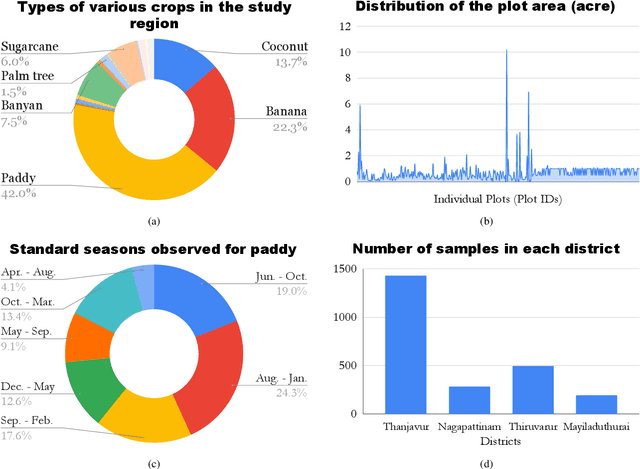
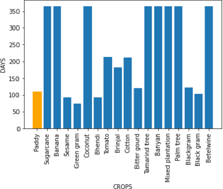
The availability of well-curated datasets has driven the success of Machine Learning (ML) models. Despite greater access to earth observation data in agriculture, there is a scarcity of curated and labelled datasets, which limits the potential of its use in training ML models for remote sensing (RS) in agriculture. To this end, we introduce a first-of-its-kind dataset called SICKLE, which constitutes a time-series of multi-resolution imagery from 3 distinct satellites: Landsat-8, Sentinel-1 and Sentinel-2. Our dataset constitutes multi-spectral, thermal and microwave sensors during January 2018 - March 2021 period. We construct each temporal sequence by considering the cropping practices followed by farmers primarily engaged in paddy cultivation in the Cauvery Delta region of Tamil Nadu, India; and annotate the corresponding imagery with key cropping parameters at multiple resolutions (i.e. 3m, 10m and 30m). Our dataset comprises 2,370 season-wise samples from 388 unique plots, having an average size of 0.38 acres, for classifying 21 crop types across 4 districts in the Delta, which amounts to approximately 209,000 satellite images. Out of the 2,370 samples, 351 paddy samples from 145 plots are annotated with multiple crop parameters; such as the variety of paddy, its growing season and productivity in terms of per-acre yields. Ours is also one among the first studies that consider the growing season activities pertinent to crop phenology (spans sowing, transplanting and harvesting dates) as parameters of interest. We benchmark SICKLE on three tasks: crop type, crop phenology (sowing, transplanting, harvesting), and yield prediction
High-Resolution Satellite Imagery for Modeling the Impact of Aridification on Crop Production
Sep 25, 2022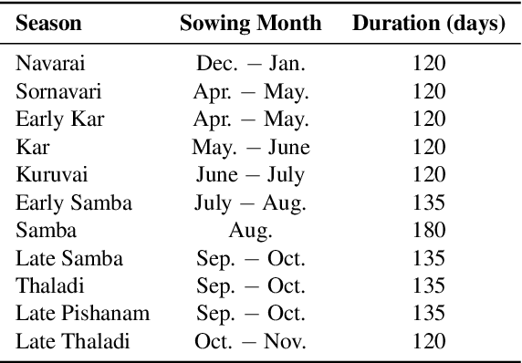
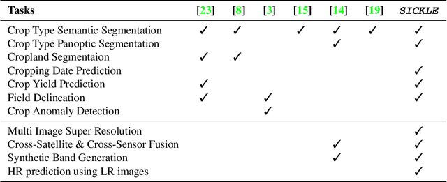
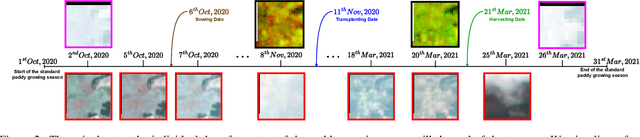
The availability of well-curated datasets has driven the success of Machine Learning (ML) models. Despite the increased access to earth observation data for agriculture, there is a scarcity of curated, labelled datasets, which limits the potential of its use in training ML models for remote sensing (RS) in agriculture. To this end, we introduce a first-of-its-kind dataset, SICKLE, having time-series images at different spatial resolutions from 3 different satellites, annotated with multiple key cropping parameters for paddy cultivation for the Cauvery Delta region in Tamil Nadu, India. The dataset comprises of 2,398 season-wise samples from 388 unique plots distributed across 4 districts of the Delta. The dataset covers multi-spectral, thermal and microwave data between the time period January 2018-March 2021. The paddy samples are annotated with 4 key cropping parameters, i.e. sowing date, transplanting date, harvesting date and crop yield. This is one of the first studies to consider the growing season (using sowing and harvesting dates) as part of a dataset. We also propose a yield prediction strategy that uses time-series data generated based on the observed growing season and the standard seasonal information obtained from Tamil Nadu Agricultural University for the region. The consequent performance improvement highlights the impact of ML techniques that leverage domain knowledge that are consistent with standard practices followed by farmers in a specific region. We benchmark the dataset on 3 separate tasks, namely crop type, phenology date (sowing, transplanting, harvesting) and yield prediction, and develop an end-to-end framework for predicting key crop parameters in a real-world setting.
Crop Type Identification for Smallholding Farms: Analyzing Spatial, Temporal and Spectral Resolutions in Satellite Imagery
May 06, 2022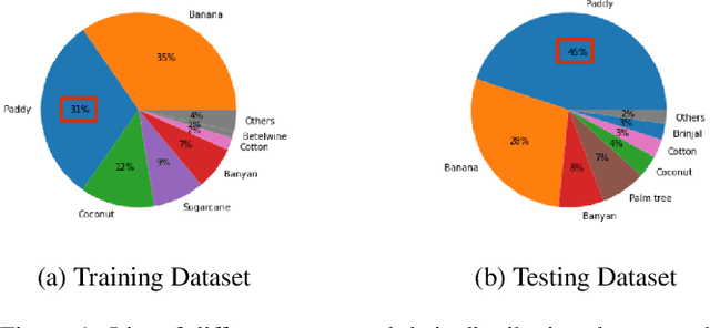
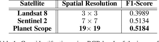
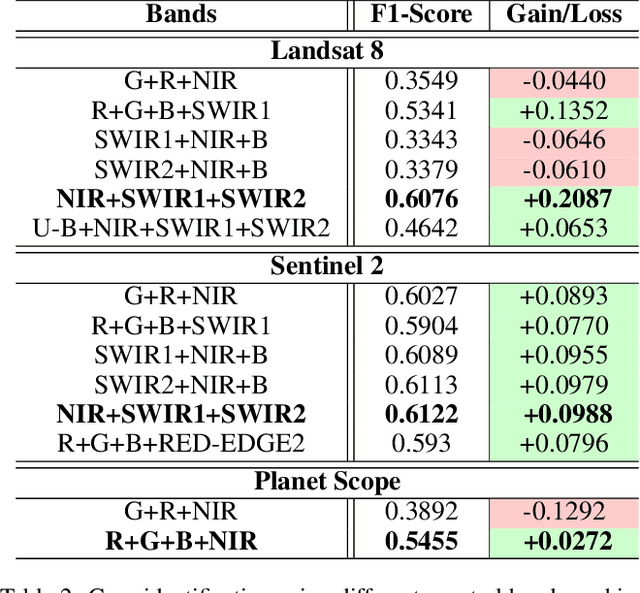
The integration of the modern Machine Learning (ML) models into remote sensing and agriculture has expanded the scope of the application of satellite images in the agriculture domain. In this paper, we present how the accuracy of crop type identification improves as we move from medium-spatiotemporal-resolution (MSTR) to high-spatiotemporal-resolution (HSTR) satellite images. We further demonstrate that high spectral resolution in satellite imagery can improve prediction performance for low spatial and temporal resolutions (LSTR) images. The F1-score is increased by 7% when using multispectral data of MSTR images as compared to the best results obtained from HSTR images. Similarly, when crop season based time series of multispectral data is used we observe an increase of 1.2% in the F1-score. The outcome motivates further advancements in the field of synthetic band generation.