 Add to Chrome
 Add to Firefox
 Add to Edge
FLORA: A deep learning approach to predict forest attributes from heterogeneous LiDAR data
Jun 30, 2026
Forest attributes are essential for national-scale resource monitoring. Airborne LiDAR metrics are among the auxiliary variables most strongly correlated with forest attributes used in National Forest Inventory (NFI) estimates. However, producing wall-to-wall predictions remains challenging when LiDAR data are acquired under heterogeneous conditions. As national LiDAR programs expand across Europe, variability in sensors, flight parameters, seasons, and scan angles limits the robustness of existing models, which are often calibrated for local conditions. We present FLORA (Forest LiDAR Octree Regression with Auxiliary Data), a deep learning framework that predicts six forest attributes: dominant height, total volume, deciduous volume, coniferous volume, basal area, and stem density from heterogeneous LiDAR point clouds. FLORA combines an octree-based backbone with ecological and spatiotemporal auxiliary variables through a late-fusion gating mechanism. Models are trained and evaluated on 32,052 National Forest Inventory plots across mainland France using data from the French LiDAR HD program. A single model trained on both leaf-on and leaf-off acquisitions outperforms season-specific models and improves cross-season robustness. Auxiliary variables provide modest overall gains but contribute more strongly to species-specific volume prediction. FLORA achieves an rRMSE of about 12.3% (R2 = 0.88) for dominant height and 39% (R2 = 0.74) for total volume, providing a robust baseline for large-scale forest attribute estimation from heterogeneous national LiDAR programs.

FORMSpoT: A Decade of Tree-Level, Country-Scale Forest Monitoring
Dec 18, 2025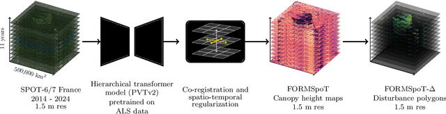
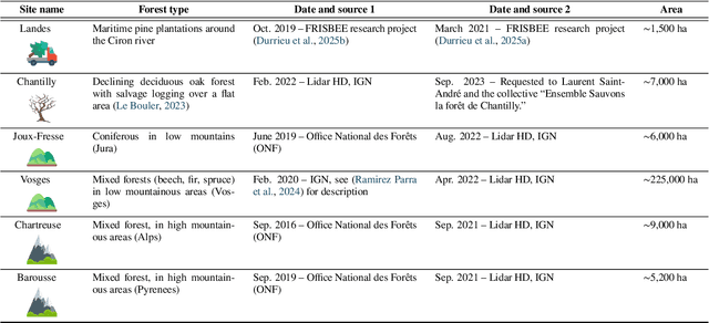
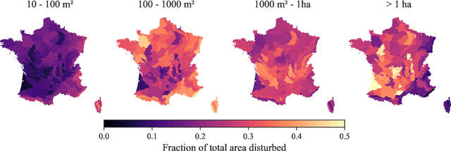
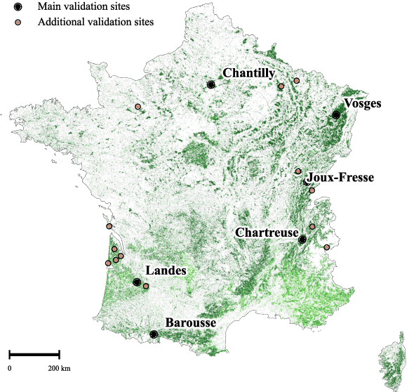
The recent decline of the European forest carbon sink highlights the need for spatially explicit and frequently updated forest monitoring tools. Yet, existing satellite-based disturbance products remain too coarse to detect changes at the scale of individual trees, typically below 100 m$^{2}$. Here, we introduce FORMSpoT (Forest Mapping with SPOT Time series), a decade-long (2014-2024) nationwide mapping of forest canopy height at 1.5 m resolution, together with annual disturbance polygons (FORMSpoT-$Δ$) covering mainland France. Canopy heights were derived from annual SPOT-6/7 composites using a hierarchical transformer model (PVTv2) trained on high-resolution airborne laser scanning (ALS) data. To enable robust change detection across heterogeneous acquisitions, we developed a dedicated post-processing pipeline combining co-registration and spatio-temporal total variation denoising. Validation against ALS revisits across 19 sites and 5,087 National Forest Inventory plots shows that FORMSpoT-$Δ$ substantially outperforms existing disturbance products. In mountainous forests, where disturbances are small and spatially fragmented, FORMSpoT-$Δ$ achieves an F1-score of 0.44, representing an order of magnitude higher than existing benchmarks. By enabling tree-level monitoring of forest dynamics at national scale, FORMSpoT-$Δ$ provides a unique tool to analyze management practices, detect early signals of forest decline, and better quantify carbon losses from subtle disturbances such as thinning or selective logging. These results underscore the critical importance of sustaining very high-resolution satellite missions like SPOT and open-data initiatives such as DINAMIS for monitoring forests under climate change.