 Add to Chrome
 Add to Firefox
 Add to Edge
An Empirical Analysis of AI Contributions to Sustainable Cities
Feb 06, 2022Artificial Intelligence (AI) presents opportunities to develop tools and techniques for addressing some of the major global challenges and deliver solutions with significant social and economic impacts. The application of AI has far-reaching implications for the 17 Sustainable Development Goals (SDGs) in general, and sustainable urban development in particular. However, existing attempts to understand and use the opportunities offered by AI for SDG 11 have been explored sparsely, and the shortage of empirical evidence about the practical application of AI remains. In this chapter, we analyze the contribution of AI to support the progress of SDG 11 (Sustainable Cities and Communities). We address the knowledge gap by empirically analyzing the AI systems (N = 29) from the AIxSDG database and the Community Research and Development Information Service (CORDIS) database. Our analysis revealed that AI systems have indeed contributed to advancing sustainable cities in several ways (e.g., waste management, air quality monitoring, disaster response management, transportation management), but many projects are still working for citizens and not with them. This snapshot of AI's impact on SDG11 is inherently partial, yet useful to advance our understanding as we move towards more mature systems and research on the impact of AI systems for social good.
FAIR Geovisualizations: Definitions, Challenges, and the Road Ahead
Nov 14, 2021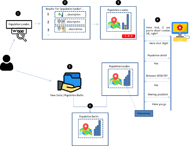
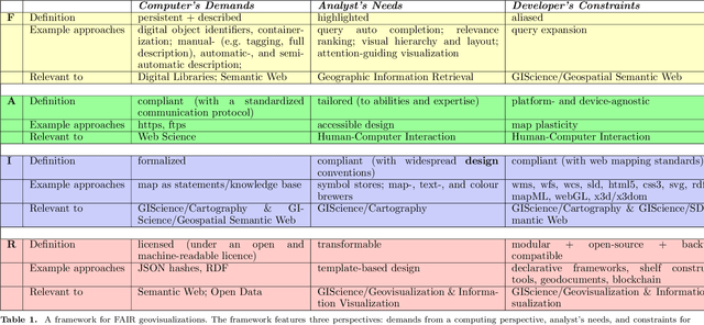
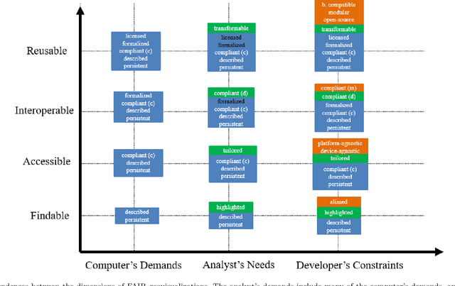
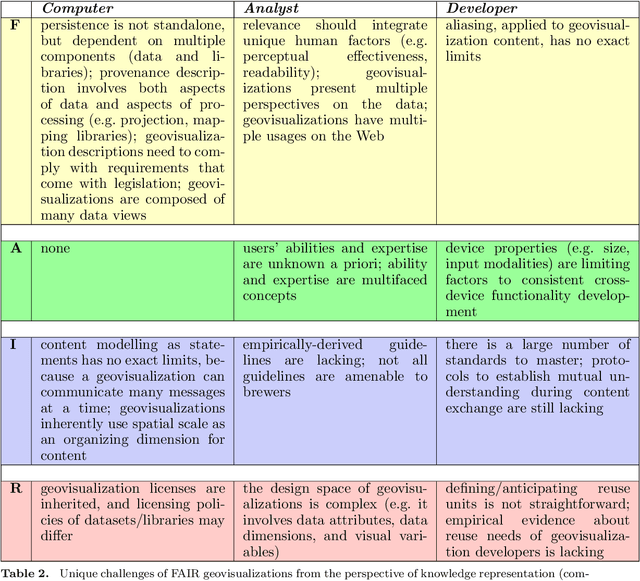
The availability of open data and of tools to create visualizations on top of these open datasets have led to an ever-growing amount of geovisualizations on the Web. There is thus an increasing need for techniques to make geovisualizations FAIR - Findable, Accessible, Interoperable, and Reusable. This article explores what it would mean for a geovisualization to be FAIR, presents relevant approaches to FAIR geovisualizations and lists open research questions on the road towards FAIR geovisualizations. The discussion is done using three complementary perspectives: the computer, which stores geovisualizations digitally; the analyst, who uses them for sensemaking; and the developer, who creates them. The framework for FAIR geovisualizations proposed, and the open questions identified are relevant to researchers working on findable, accessible, interoperable, and reusable online visualizations of geographic information.