 Add to Chrome
 Add to Firefox
 Add to Edge
Coarse-to-Fine Domain Incremental Learning with Attentive Distillation for Mining Footprint Segmentation in Multispectral Imagery
May 28, 2026
Automatically mapping and segmenting global mining footprints using remote sensing and deep learning is critical for monitoring the socio-environmental risks and impacts of mining, yet its progress is hindered by the scarcity of fine-grained annotated data. Although large-scale datasets with coarse boundaries are widely available, leveraging them to improve fine-grained segmentation is challenging due to significant domain shift. To address this, we propose MineC2FNet, a coarse-to-fine domain incremental learning framework that exploits abundant coarse data to enhance fine-grained mining footprint segmentation. MineC2FNet adopts a teacher-student architecture with attentive distillation at both the feature and prediction levels, selectively transferring generalized knowledge from the coarse domain while enabling boundary refinement using limited fine-grained data (fine domain). We further introduce an expertly validated dataset of 219 images with precise boundary annotations across diverse geographies and commodities. Extensive experiments against state-of-the-art approaches, including domain adaptation and domain incremental learning methods, demonstrate that MineC2FNet achieves superior performance while effectively handling domain shift. The dataset and code are publicly available at https://github.com/risqiutama/MineC2FNet.

Progressive Cross Attention Network for Flood Segmentation using Multispectral Satellite Imagery
Jan 21, 2025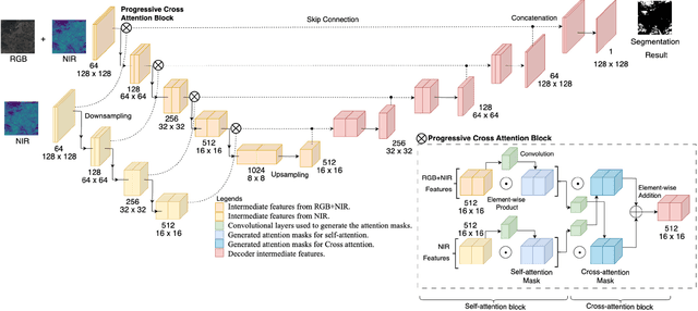


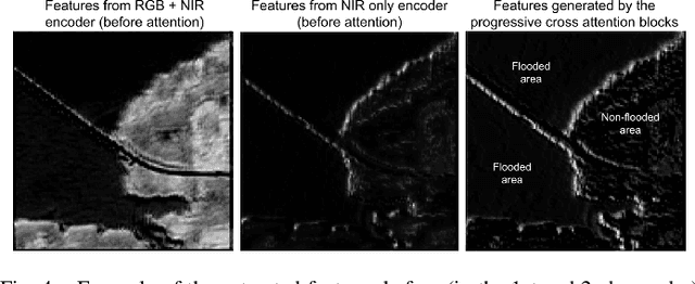
In recent years, the integration of deep learning techniques with remote sensing technology has revolutionized the way natural hazards, such as floods, are monitored and managed. However, existing methods for flood segmentation using remote sensing data often overlook the utility of correlative features among multispectral satellite information. In this study, we introduce a progressive cross attention network (ProCANet), a deep learning model that progressively applies both self- and cross-attention mechanisms to multispectral features, generating optimal feature combinations for flood segmentation. The proposed model was compared with state-of-the-art approaches using Sen1Floods11 dataset and our bespoke flood data generated for the Citarum River basin, Indonesia. Our model demonstrated superior performance with the highest Intersection over Union (IoU) score of 0.815. Our results in this study, coupled with the ablation assessment comparing scenarios with and without attention across various modalities, opens a promising path for enhancing the accuracy of flood analysis using remote sensing technology.
* 5 pages, 4 figures, published in IEEE Geoscience and Remote Sensing Letters