 Add to Chrome
 Add to Firefox
 Add to Edge
Zhuoyuan Song
Heterogeneous Fixed-wing Aerial Vehicles for Resilient Coverage of an Area
Sep 17, 2020
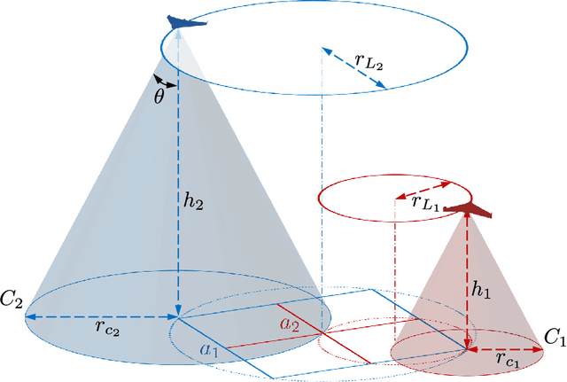
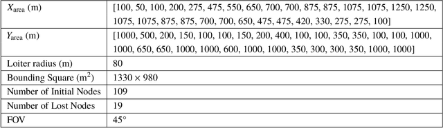
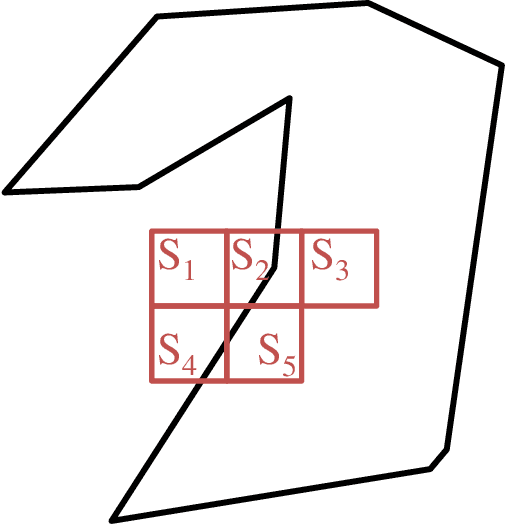
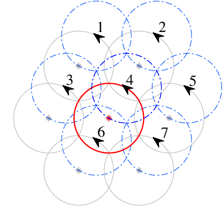
This paper presents a distributed approach to provide persistent coverage of an arbitrarily shaped area using heterogeneous coverage of fixed-wing unmanned aerial vehicles (UAVs), and to recover from simultaneous failures of multiple UAVs. The proposed approach discusses level-homogeneous deployment and maintenance of a homogeneous fleet of fixed-wing UAVs given the boundary information and the minimum loitering radius. The UAVs are deployed at different altitude levels to provide heterogeneous coverage and sensing. We use an efficient square packing method to deploy the UAVs, given the minimum loiter radius and the area boundary. The UAVs loiter over the circles inscribed over these packing squares in a synchronized motion to fulfill the full coverage objective. An top-down hierarchy of the square packing, where each outer square (super-square) is partitioned into four equal-sized inner squares (sub-square), is exploited to introduce resilience in the deployed UAV-network. For a failed sub-square UAV, a replacement neighbor is chosen considering the effective coverage and deployed to the corresponding super-square at a higher altitude to recover full coverage, trading-off with the quality of coverage of the sub-area. This is a distributed approach as all the decision making is done within close range of the loss region, and it can be scaled and adapted to various large scale area and UAV configurations. Simulation results have been presented to illustrate and verify the applicability of the approach.
Coordinated Coverage and Fault Tolerance using Fixed-Wing Unmanned Aerial Vehicles
May 17, 2020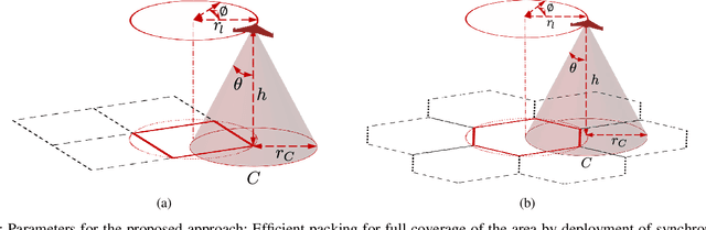
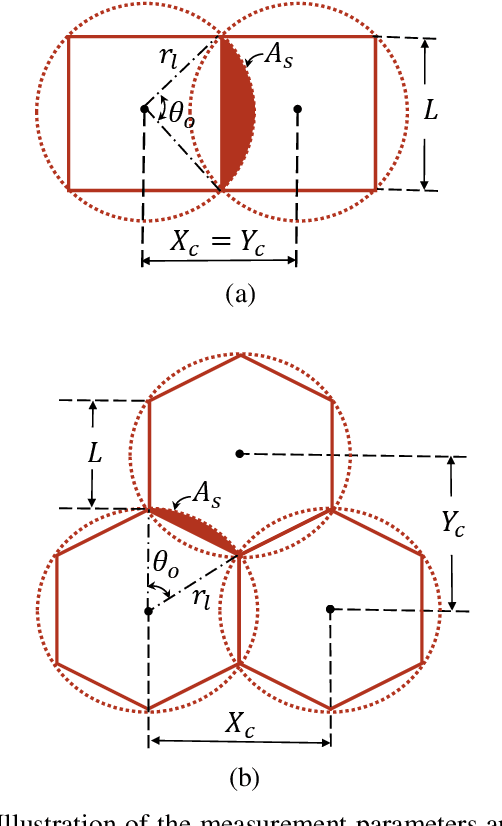
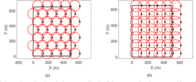
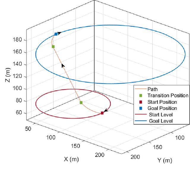
This paper presents an approach for deploying and maintaining a fleet of homogeneous fixed-wing unmanned aerial vehicles (UAVs) for all-time coverage of an area. Two approaches for loiter circle packing have been presented: square and hexagon packing, and the benefits of hexagon packing for minimizing the number of deployed UAVs have been shown. Based on the number of UAVs available and the desired loitering altitude, the proposed algorithm solves an optimization problem to calculate the centres of the loitering circles and the loitering radius for that altitude. The algorithm also incorporates fault recovery capacity in case of simultaneous multiple UAV failures. These failures could form clusters of survivor (active) UAVs over the area with no overall survivor information. The algorithm deploys a super-agent with a larger communication capacity at a higher altitude to recover from the failure. The super-agent collects the information of survivors, and updates the homogeneous radius and the locations of the loitering circles at the same altitude to restore the full coverage. The individual survivor UAVs are then informed and transit to the new loitering circles using Dubin's paths. The relationship with the extent of recoverable loss fractions of the deployed UAVs have been analysed for varying the initial loiter radii. Simulation results have been presented to demonstrate the applicability of the approach and compare the two presented packing approaches.
Concurrent Flow-Based Localization and Mapping in Time-Invariant Flow Fields
Oct 15, 2019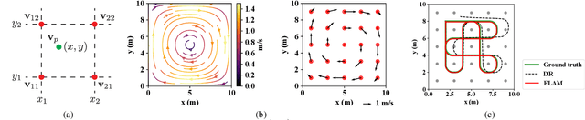
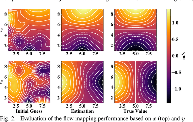
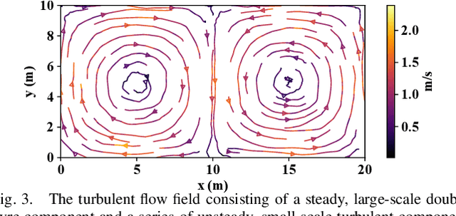
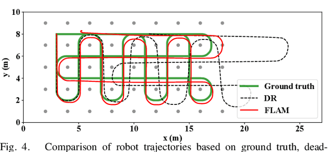
We present the concept of concurrent flow-based localization and mapping (FLAM) for autonomous field robots navigating within background flows. Different from the classical simultaneous localization and mapping (SLAM) problem, where the robot interacts with discrete features, FLAM utilizes the continuous flow fields as navigation references for mobile robots and provides flow field mapping capability with in-situ flow velocity observations. This approach is of importance to underwater vehicles in mid-depth oceans or aerial vehicles in GPS-denied atmospheric circulations. This article introduces the formulation of FLAM as a full SLAM solution motivated by the feature-based GraphSLAM framework. The performance of FLAM was demonstrated through simulation within artificial flow fields that represent typical geophysical circulation phenomena: a steady single-gyre flow field and a double-gyre flow field with unsteady turbulent perturbations. The results indicate that FLAM provides significant improvements in the robots' localization accuracy and a consistent approximation of the background flow field. It is also shown that FLAM leads to smooth robot trajectory estimates.
Long-Term Inertial Navigation Aided by Dynamics of Flow Field Features
Oct 13, 2017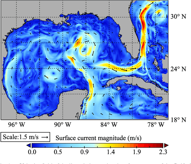
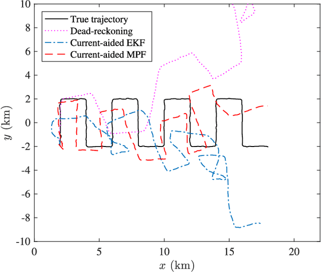
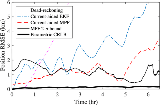
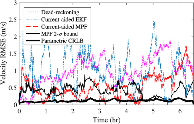
A current-aided inertial navigation framework is proposed for small autonomous underwater vehicles in long-duration operations (> 1 hour), where neither frequent surfacing nor consistent bottom-tracking are available. We instantiate this concept through mid-depth, underwater navigation. This strategy mitigates dead-reckoning uncertainty of a traditional inertial navigation system by comparing the estimate of local, ambient flow velocity with preloaded ocean current maps. The proposed navigation system is implemented through a marginalized particle filter where the vehicle's states are sequentially tracked along with sensor bias and local turbulence that is not resolved by general flow prediction. The performance of the proposed approach is first analyzed through Monte Carlo simulations in two artificial background flow fields, resembling real-world ocean circulation patterns, superposed with smaller-scale, turbulent components with Kolmogorov energy spectrum. The current-aided navigation scheme significantly improves the dead-reckoning performance of the vehicle even when unresolved, small-scale flow perturbations are present. For a 6-hour navigation with an automotive-grade inertial navigation system, the current-aided navigation scheme results in positioning estimates with under 3% uncertainty per distance traveled (UDT) in a turbulent, double-gyre flow field, and under 7.3% UDT in a turbulent, meandering jet flow field. Further evaluation with field test data and actual ocean simulation analysis demonstrates consistent performance for a 6-hour mission, positioning result with under 25% UDT for a 24-hour navigation when provided direct heading measurements, and terminal positioning estimate with 16% UDT at the cost of increased uncertainty at an early stage of the navigation.