 Add to Chrome
 Add to Firefox
 Add to Edge
BigEarthNet-MM: A Large Scale Multi-Modal Multi-Label Benchmark Archive for Remote Sensing Image Classification and Retrieval
May 17, 2021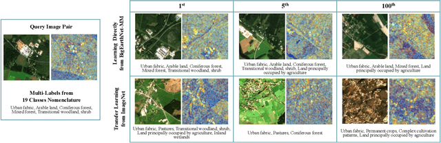
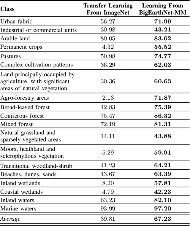
This paper presents the multi-modal BigEarthNet (BigEarthNet-MM) benchmark archive made up of 590,326 pairs of Sentinel-1 and Sentinel-2 image patches to support the deep learning (DL) studies in multi-modal multi-label remote sensing (RS) image retrieval and classification. Each pair of patches in BigEarthNet-MM is annotated with multi-labels provided by the CORINE Land Cover (CLC) map of 2018 based on its thematically most detailed Level-3 class nomenclature. Our initial research demonstrates that some CLC classes are challenging to be accurately described by only considering (single-date) BigEarthNet-MM images. In this paper, we also introduce an alternative class-nomenclature as an evolution of the original CLC labels to address this problem. This is achieved by interpreting and arranging the CLC Level-3 nomenclature based on the properties of BigEarthNet-MM images in a new nomenclature of 19 classes. In our experiments, we show the potential of BigEarthNet-MM for multi-modal multi-label image retrieval and classification problems by considering several state-of-the-art DL models. We also demonstrate that the DL models trained from scratch on BigEarthNet-MM outperform those pre-trained on ImageNet, especially in relation to some complex classes, including agriculture and other vegetated and natural environments. We make all the data and the DL models publicly available at https://bigearth.net, offering an important resource to support studies on multi-modal image scene classification and retrieval problems in RS.
BigEarthNet Dataset with A New Class-Nomenclature for Remote Sensing Image Understanding
Feb 18, 2020
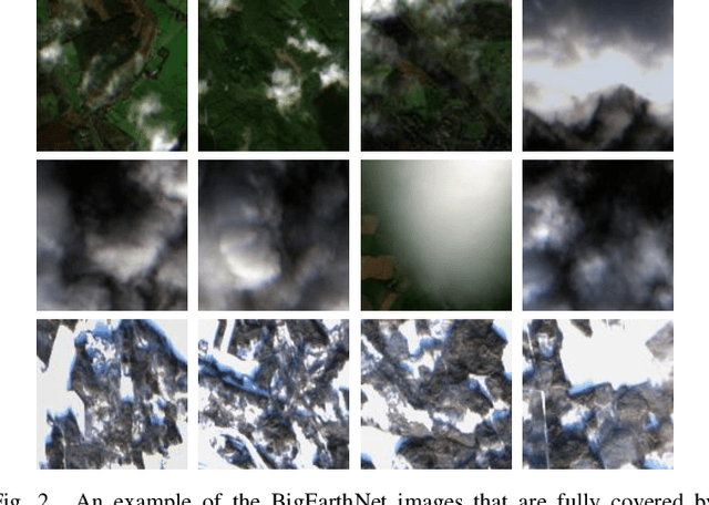
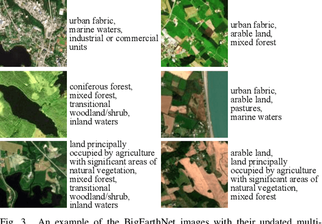
This paper presents BigEarthNet that is a large-scale Sentinel-2 multispectral image dataset with a new class nomenclature to advance deep learning (DL) studies in remote sensing (RS). BigEarthNet is made up of 590,326 image patches annotated with multi-labels provided by the CORINE Land Cover (CLC) map of 2018 based on its most thematic detailed Level-3 class nomenclature. Initial research demonstrates that some CLC classes are challenging to be accurately described by considering only Sentinel-2 images. To increase the effectiveness of BigEarthNet, in this paper we introduce an alternative class-nomenclature to allow DL models for better learning and describing the complex spatial and spectral information content of the Sentinel-2 images. This is achieved by interpreting and arranging the CLC Level-3 nomenclature based on the properties of Sentinel-2 images in a new nomenclature of 19 classes. Then, the new class-nomenclature of BigEarthNet is used within state-of-the-art DL models in the context of multi-label classification. Results show that the models trained from scratch on BigEarthNet outperform those pre-trained on ImageNet, especially in relation to some complex classes including agriculture, other vegetated and natural environments. All DL models are made publicly available at http://bigearth.net/#downloads, offering an important resource to guide future progress on RS image analysis.